Headwaters To Boundary Of Rocky Mountain National Park River Run
Community Reviews
Been here? Share the conditions.
Reviews, ratings & photos are added in the free Snoflo iOS app — rate a spot, tag the conditions, and your visit is verified by location. Add or manage your reviews from the app.
Headwaters To Boundary Of Rocky Mountain National Park
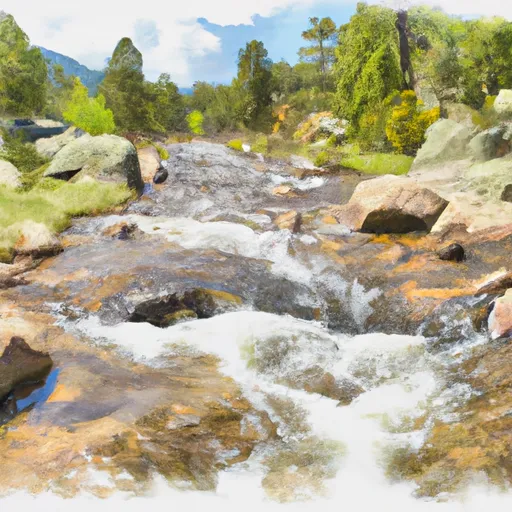
The river run is approximately 26 miles long, and can be divided into three segments. The first segment is from the headwaters to the town of Tabernash, which is approximately 7 miles long and rated as Class II-III. The second segment is from Tabernash to the town of Granby and is approximately 10 miles long, with a rating of Class III-IV. The final segment is from Granby to the boundary of Rocky Mountain National Park, which is approximately 9 miles long and rated as Class II-III.
The river features several rapids and obstacles, including the Railroad Rapids, which is a Class III rapid that requires precise navigation to avoid rocks and other obstacles in the river. There are also several other Class III-IV rapids throughout the river, such as the Devil’s Elbow and the Pinball Rapids.
There are specific regulations in place for the Whitewater River Run, including a requirement for all boaters to wear personal flotation devices and a restriction on the use of motorized watercraft. Additionally, all participants in the river run must adhere to Leave No Trace principles, including properly disposing of trash and minimizing the impact on the surrounding natural environment.
Plan your run down to the hour
Same weather feed Snoflo's iOS app uses -- updated continuously from NOAA / yr.no. Watch the precipitation column on the meteogram; rain ahead of a run typically lifts flows 12-48 hours later depending on the basin.
Next 5 days, hour by hour
Temperature line with weather symbols on top, snow + rain accumulation as columns, humidity as a dotted line.
5-day forecast table
Every 3 hours, broken out across temperature, snow, rain, humidity, and wind. Each cell is colour-coded relative to the column min/max.
| Time | Condition | Temp (°F) | Snow (in) | Rain (in) | Humidity (%) | Wind (mps) | Wind dir |
|---|---|---|---|---|---|---|---|
| Loading detailed forecast… | |||||||
15-day temperature & precipitation
Daily temperatures, snow, and rain projected over the next two weeks -- the upstream story that drives next week's flows.
Regional streamflow levels
USGS streamgauges around Headwaters To Boundary Of Rocky Mountain National Park -- useful for spotting upstream pulses and gauging which tributary is contributing what.
| Streamgauge | Discharge | View |
|---|---|---|
| Grand River Ditch At La Poudre Pass | 17 cfs | → |
| Michigan River Near Cameron Pass | 1 cfs | → |
| Joe Wright Creek Below Joe Wright Reservoir | 40 cfs | → |
| Joe Wright Creek Above Joe Wright Reservoir | 3 cfs | → |
| Colorado R Below Baker Gulch | 23 cfs | → |
| Grand Lake Outlet Blw Chipmunk Ln At Grand Lk | 193 cfs | → |
Plan a longer trip
The closest boat launches, other paddle runs, and campgrounds so a day on the water can grow into a full weekend.
Other river runs
- Headwaters To Fan Lake
- Headwaters To Ends 0.5 Miles Upstream From End Of Fern Lake Road
- Big South
- Begins 0.5 Miles Upstream From End Of Fern Lake Road To Eastern Boundary Of Rocky Mountain National Park
- Begins 0.5 Miles Away From Trail Ridge Road To Ends Where River Segment Exits Rocky Mountain National Park
Campgrounds
- Lawn Lake Site 1
- Lawn Lake Campsite 3
- Lawn Lake Llama Campsite
- Lower Tileston
- Golden Banner Campsite (East) (Approx)
- Golden Banner Campsite (West)
Fishing spots
Whitewater safety
- Check the flow before you run
- Use the linked-gauge card and Regional Flow panel above. Class ratings change with flow -- a Class III at low water can become Class IV+ at high water.
- Know your skill ceiling
- Pick runs comfortably below your ceiling. Cold-water and big-water runs raise the consequences of any mistake.
- Wear the right gear
- Helmet, PFD, drysuit / wetsuit when water is below 60°F. Throw bag, knife, and whistle on your person, not in the boat.
- Scout, set safety, and run with a team
- Scout new rapids on foot, set safety with throw bags above the consequence pool, and run with at least one other competent paddler.
- Respect the river
- Strainers, undercuts, low-head dams, and wood can kill at any class rating. When in doubt, portage.
Set push alerts in the Snoflo app
Save Headwaters To Boundary Of Rocky Mountain National Park as a favorite, set a discharge threshold (e.g. "alert me when flow hits 600 cfs"), and the iOS app pushes the moment the linked gauge crosses.
About Headwaters To Boundary Of Rocky Mountain National Park
What's the optimal flow for Headwaters To Boundary Of Rocky Mountain National Park?
The optimal flow depends on the section and the craft. Check the Run Details panel for the linked gauge and current status.
How fresh is the cfs reading on this page?
The linked USGS streamgauge reports continuously (every 15 minutes); Snoflo refreshes throughout the day. Hover the streamflow sparkline to read individual datapoints.
What's the whitewater class?
See the Run Details panel for the class rating Snoflo tracks for this run. Class ratings change with flow -- a Class III at low water can become Class IV in high water.
Where do I put in / take out?
Tap Directions in the hero above to open driving directions to the put-in. For shuttle planning, check the Nearby Boat Launches panel and the river run operator's site.
Can I get alerts when flows hit the optimal range?
Yes -- alerts are managed in the Snoflo iOS app. Favorite this run, set a discharge threshold, and you'll get a push the moment the gauge crosses.
Other runs near here
Snoflo-tracked paddle runs within driving distance of Headwaters To Boundary Of Rocky Mountain National Park.