Gunnison River Segment 2 river run
Community Reviews
Been here? Share the conditions.
Reviews, ratings & photos are added in the free Snoflo iOS app — rate a spot, tag the conditions, and your visit is verified by location. Add or manage your reviews from the app.
Gunnison River Segment 2
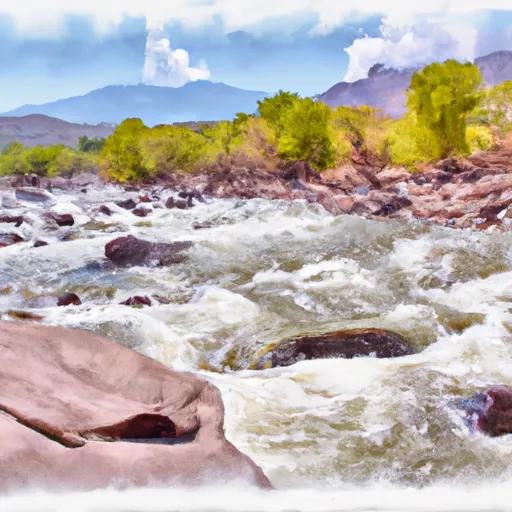
The Gunnison River Segment 2 is an exciting whitewater river run located in the state of Colorado. This segment is approximately 14 miles long and includes several class III and IV rapids, including the infamous Squeeze Play Rapid.
The ideal streamflow range for this segment is between 1,500 and 3,000 cfs. This flow offers a challenging yet manageable experience for intermediate and advanced paddlers.
This segment is rated as a class III-IV run, with some sections reaching class V during high-water flows. The rapids and obstacles on this segment include Squeeze Play, Stonefly, and Boat Eater, all of which require precise navigation and technical skill.
There are specific regulations in place for this area, including permits and camping restrictions. Paddlers must obtain a permit from the Bureau of Land Management before entering the area, and all camping must be done in designated campsites.
Overall, the Gunnison River Segment 2 is a thrilling whitewater river run that offers a challenging adventure for experienced paddlers. It is important to check current streamflow conditions and comply with all regulations before embarking on this exciting journey.
Plan your run down to the hour
Same weather feed Snoflo's iOS app uses -- updated continuously from NOAA / yr.no. Watch the precipitation column on the meteogram; rain ahead of a run typically lifts flows 12-48 hours later depending on the basin.
Next 5 days, hour by hour
Temperature line with weather symbols on top, snow + rain accumulation as columns, humidity as a dotted line.
5-day forecast table
Every 3 hours, broken out across temperature, snow, rain, humidity, and wind. Each cell is colour-coded relative to the column min/max.
| Time | Condition | Temp (°F) | Snow (in) | Rain (in) | Humidity (%) | Wind (mps) | Wind dir |
|---|---|---|---|---|---|---|---|
| Loading detailed forecast… | |||||||
15-day temperature & precipitation
Daily temperatures, snow, and rain projected over the next two weeks -- the upstream story that drives next week's flows.
Regional streamflow levels
USGS streamgauges around Gunnison River Segment 2 -- useful for spotting upstream pulses and gauging which tributary is contributing what.
| Streamgauge | Discharge | View |
|---|---|---|
| Gunnison River At Delta | 554 cfs | → |
| Uncompahgre River At Delta | 111 cfs | → |
| Surface Creek At Cedaredge | 9 cfs | → |
| North Fk Gunnison River Above Mouth Nr Lazear | 31 cfs | → |
| N.F. Gunnison R Blw Leroux Cr | 47 cfs | → |
| Surface Creek Near Cedaredge | 24 cfs | → |
Plan a longer trip
The closest boat launches, other paddle runs, and campgrounds so a day on the water can grow into a full weekend.
Boat launches
- Sweitzer Lake State Park
- Shea Road Delta County
- Orchard Boat Launch
- South River Road Delta County
- Delta County
- Gunnison Forks
Other river runs
- Roubideau Creek Segment 2
- Roubideau Creek Segment 1
- Potter Creek
- The Painted Wall To The Black Canyon Gunnison National Monument-Gunnison Gorge Wilderness Boundary
- Monitor Creek
Campgrounds
- Cottonwood Grove Campground
- Entrada Bench (Across From Enhanted Camp)
- Enchanted Forest
- Blacker
- T Dyke
- Boulder Garden
Fishing spots
- Confluence Lake
- Gunnison River
- Sweitzer Lake
- Fruitgrowers Reservoir
- Porter Reservoir #1
- Porter Reservoir #4 (Little Davies)
Parks
Points of interest
Whitewater safety
- Check the flow before you run
- Use the linked-gauge card and Regional Flow panel above. Class ratings change with flow -- a Class III at low water can become Class IV+ at high water.
- Know your skill ceiling
- Pick runs comfortably below your ceiling. Cold-water and big-water runs raise the consequences of any mistake.
- Wear the right gear
- Helmet, PFD, drysuit / wetsuit when water is below 60°F. Throw bag, knife, and whistle on your person, not in the boat.
- Scout, set safety, and run with a team
- Scout new rapids on foot, set safety with throw bags above the consequence pool, and run with at least one other competent paddler.
- Respect the river
- Strainers, undercuts, low-head dams, and wood can kill at any class rating. When in doubt, portage.
Set push alerts in the Snoflo app
Save Gunnison River Segment 2 as a favorite, set a discharge threshold (e.g. "alert me when flow hits 600 cfs"), and the iOS app pushes the moment the linked gauge crosses.
About Gunnison River Segment 2
What's the optimal flow for Gunnison River Segment 2?
The optimal flow depends on the section and the craft. Check the Run Details panel for the linked gauge and current status.
How fresh is the cfs reading on this page?
The linked USGS streamgauge reports continuously (every 15 minutes); Snoflo refreshes throughout the day. Hover the streamflow sparkline to read individual datapoints.
What's the whitewater class?
See the Run Details panel for the class rating Snoflo tracks for this run. Class ratings change with flow -- a Class III at low water can become Class IV in high water.
Where do I put in / take out?
Tap Directions in the hero above to open driving directions to the put-in. For shuttle planning, check the Nearby Boat Launches panel and the river run operator's site.
Can I get alerts when flows hit the optimal range?
Yes -- alerts are managed in the Snoflo iOS app. Favorite this run, set a discharge threshold, and you'll get a push the moment the gauge crosses.
Other runs near here
Snoflo-tracked paddle runs within driving distance of Gunnison River Segment 2.