Pinehaven Subdivision To Riverside Campground River Run
Community Reviews
Been here? Share the conditions.
Reviews, ratings & photos are added in the free Snoflo iOS app — rate a spot, tag the conditions, and your visit is verified by location. Add or manage your reviews from the app.
Pinehaven Subdivision To Riverside Campground
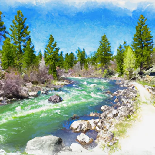
This run features several notable rapids, including Pinball, Meatgrinder, and Piece of Cake. Pinball is a technical rapid with several rocks and drops to navigate through, while Meatgrinder is a steep drop with a large hydraulic that requires precise maneuvering. Piece of Cake is a long rapid with several technical moves required to successfully navigate through it.
There are specific regulations in place for this area, including a permit requirement for commercial outfitters and a prohibition on camping along the riverbanks. Additionally, all paddlers are required to wear a personal flotation device and carry a whistle.
Overall, the Pinehaven Subdivision to Riverside Campground run on the Whitewater River in Idaho is a challenging and exciting whitewater experience for experienced paddlers. It is important to note that water levels can fluctuate rapidly, so paddlers should always be prepared and aware of their surroundings.
Plan your run down to the hour
Same weather feed Snoflo's iOS app uses -- updated continuously from NOAA / yr.no. Watch the precipitation column on the meteogram; rain ahead of a run typically lifts flows 12-48 hours later depending on the basin.
Next 5 days, hour by hour
Temperature line with weather symbols on top, snow + rain accumulation as columns, humidity as a dotted line.
5-day forecast table
Every 3 hours, broken out across temperature, snow, rain, humidity, and wind. Each cell is colour-coded relative to the column min/max.
| Time | Condition | Temp (°F) | Snow (in) | Rain (in) | Humidity (%) | Wind (mps) | Wind dir |
|---|---|---|---|---|---|---|---|
| Loading detailed forecast… | |||||||
15-day temperature & precipitation
Daily temperatures, snow, and rain projected over the next two weeks -- the upstream story that drives next week's flows.
Regional streamflow levels
USGS streamgauges around Pinehaven Subdivision To Riverside Campground -- useful for spotting upstream pulses and gauging which tributary is contributing what.
| Streamgauge | Discharge | View |
|---|---|---|
| Henrys Fork Nr Island Park Id | 1,350 cfs | → |
| Henrys Fork Nr Ashton Id | 1,680 cfs | → |
| Henrys Fork Blw Coffee Pot Rapids Nr Macks Inn Id | 372 cfs | → |
| Falls River Nr Ashton Id | 536 cfs | → |
| Falls River Nr Squirrel Id | 226 cfs | → |
| Falls River Nr Chester Id | 388 cfs | → |
Plan a longer trip
The closest boat launches, other paddle runs, and campgrounds so a day on the water can grow into a full weekend.
Boat launches
- Riverside Campground Road Fremont County
- East Hatchery Ford Boating Site
- Old Highway Island Park
- West End
- Box Canyon
- Ashton Reservoir
Other river runs
- Northern Boundary Of Harriman Park To Pinehaven Subdivision
- Box Canyon Summer Homes To Northern Boundary Of Harriman Park
- Island Park Dam To Box Canyon Summer Homes
- Box Canyon
- Elk Creek To Slackwater Of Ponds Power Dam
Campgrounds
Fishing spots
Points of interest
Whitewater safety
- Check the flow before you run
- Use the linked-gauge card and Regional Flow panel above. Class ratings change with flow -- a Class III at low water can become Class IV+ at high water.
- Know your skill ceiling
- Pick runs comfortably below your ceiling. Cold-water and big-water runs raise the consequences of any mistake.
- Wear the right gear
- Helmet, PFD, drysuit / wetsuit when water is below 60°F. Throw bag, knife, and whistle on your person, not in the boat.
- Scout, set safety, and run with a team
- Scout new rapids on foot, set safety with throw bags above the consequence pool, and run with at least one other competent paddler.
- Respect the river
- Strainers, undercuts, low-head dams, and wood can kill at any class rating. When in doubt, portage.
Set push alerts in the Snoflo app
Save Pinehaven Subdivision To Riverside Campground as a favorite, set a discharge threshold (e.g. "alert me when flow hits 600 cfs"), and the iOS app pushes the moment the linked gauge crosses.
About Pinehaven Subdivision To Riverside Campground
What's the optimal flow for Pinehaven Subdivision To Riverside Campground?
The optimal flow depends on the section and the craft. Check the Run Details panel for the linked gauge and current status.
How fresh is the cfs reading on this page?
The linked USGS streamgauge reports continuously (every 15 minutes); Snoflo refreshes throughout the day. Hover the streamflow sparkline to read individual datapoints.
What's the whitewater class?
See the Run Details panel for the class rating Snoflo tracks for this run. Class ratings change with flow -- a Class III at low water can become Class IV in high water.
Where do I put in / take out?
Tap Directions in the hero above to open driving directions to the put-in. For shuttle planning, check the Nearby Boat Launches panel and the river run operator's site.
Can I get alerts when flows hit the optimal range?
Yes -- alerts are managed in the Snoflo iOS app. Favorite this run, set a discharge threshold, and you'll get a push the moment the gauge crosses.
Other runs near here
Snoflo-tracked paddle runs within driving distance of Pinehaven Subdivision To Riverside Campground.