Source To Upper Palisades Lake River Run
Community Reviews
Been here? Share the conditions.
Reviews, ratings & photos are added in the free Snoflo iOS app — rate a spot, tag the conditions, and your visit is verified by location. Add or manage your reviews from the app.
Source To Upper Palisades Lake
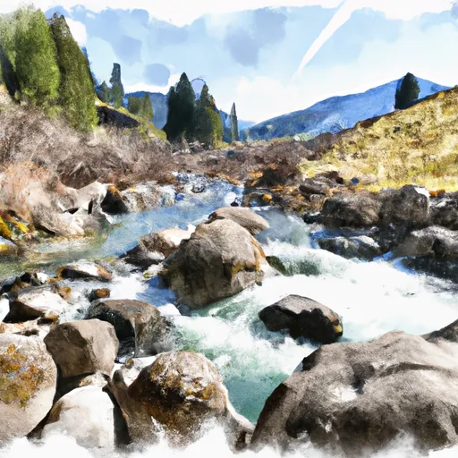
The segment mileage for this run is approximately 16 miles, with a put-in at the Source and a take-out at Upper Palisades Lake. Along the way, paddlers will encounter several obstacles such as boulder gardens, tight chutes, and large standing waves. This run requires advanced skill and experience, as the rapids are technical and require precise maneuvering.
In addition to the difficulty level, there are also specific regulations to this area that must be followed. The Whitewater River Run is located within the Targhee National Forest, and a permit is required to access the river. Additionally, all boaters must wear a personal flotation device and adhere to Leave No Trace principles to protect the natural environment.
Overall, the Whitewater River Run from Source to Upper Palisades Lake offers a challenging and exciting adventure for experienced whitewater paddlers. It is essential to check current streamflow levels and obtain the necessary permits before embarking on this journey.
Plan your run down to the hour
Same weather feed Snoflo's iOS app uses -- updated continuously from NOAA / yr.no. Watch the precipitation column on the meteogram; rain ahead of a run typically lifts flows 12-48 hours later depending on the basin.
Next 5 days, hour by hour
Temperature line with weather symbols on top, snow + rain accumulation as columns, humidity as a dotted line.
5-day forecast table
Every 3 hours, broken out across temperature, snow, rain, humidity, and wind. Each cell is colour-coded relative to the column min/max.
| Time | Condition | Temp (°F) | Snow (in) | Rain (in) | Humidity (%) | Wind (mps) | Wind dir |
|---|---|---|---|---|---|---|---|
| Loading detailed forecast… | |||||||
15-day temperature & precipitation
Daily temperatures, snow, and rain projected over the next two weeks -- the upstream story that drives next week's flows.
Regional streamflow levels
USGS streamgauges around Source To Upper Palisades Lake -- useful for spotting upstream pulses and gauging which tributary is contributing what.
| Streamgauge | Discharge | View |
|---|---|---|
| Snake River Nr Irwin Id | 13,700 cfs | → |
| Fish Creek At Wilson | 412 cfs | → |
| Snake River Ab Reservoir Nr Alpine Wy | 7,300 cfs | → |
| Flat Creek Bel Cache Creek | 220 cfs | → |
| Greys River Ab Reservoir Nr Alpine Wy | 403 cfs | → |
| Snake River Bl Flat Creek Nr Jackson Wy | 7,280 cfs | → |
Plan a longer trip
The closest boat launches, other paddle runs, and campgrounds so a day on the water can grow into a full weekend.
Boat launches
Other river runs
- Mainstem And Lower 2 Miles Of North, South And Siddoway Forks To One Mile Above Trailhead
- One Mile Above Trailhead To Trailhead
- Confluence Of North Fork Palisades Creek And Corral Canyon To Palisades Campground
- Palisade Dam To Lorenzo (South Fork)
- South Fork Snake River
Campgrounds
Fishing spots
Parks
Whitewater safety
- Check the flow before you run
- Use the linked-gauge card and Regional Flow panel above. Class ratings change with flow -- a Class III at low water can become Class IV+ at high water.
- Know your skill ceiling
- Pick runs comfortably below your ceiling. Cold-water and big-water runs raise the consequences of any mistake.
- Wear the right gear
- Helmet, PFD, drysuit / wetsuit when water is below 60°F. Throw bag, knife, and whistle on your person, not in the boat.
- Scout, set safety, and run with a team
- Scout new rapids on foot, set safety with throw bags above the consequence pool, and run with at least one other competent paddler.
- Respect the river
- Strainers, undercuts, low-head dams, and wood can kill at any class rating. When in doubt, portage.
Set push alerts in the Snoflo app
Save Source To Upper Palisades Lake as a favorite, set a discharge threshold (e.g. "alert me when flow hits 600 cfs"), and the iOS app pushes the moment the linked gauge crosses.
About Source To Upper Palisades Lake
What's the optimal flow for Source To Upper Palisades Lake?
The optimal flow depends on the section and the craft. Check the Run Details panel for the linked gauge and current status.
How fresh is the cfs reading on this page?
The linked USGS streamgauge reports continuously (every 15 minutes); Snoflo refreshes throughout the day. Hover the streamflow sparkline to read individual datapoints.
What's the whitewater class?
See the Run Details panel for the class rating Snoflo tracks for this run. Class ratings change with flow -- a Class III at low water can become Class IV in high water.
Where do I put in / take out?
Tap Directions in the hero above to open driving directions to the put-in. For shuttle planning, check the Nearby Boat Launches panel and the river run operator's site.
Can I get alerts when flows hit the optimal range?
Yes -- alerts are managed in the Snoflo iOS app. Favorite this run, set a discharge threshold, and you'll get a push the moment the gauge crosses.
Other runs near here
Snoflo-tracked paddle runs within driving distance of Source To Upper Palisades Lake.