Middle Fork Bull River, Sec. 9, T28n, R33w To Proposed Addition To Cabinet Mtns Wilderness, Sec. 12, T28n, R33w River Run
Community Reviews
Been here? Share the conditions.
Reviews, ratings & photos are added in the free Snoflo iOS app — rate a spot, tag the conditions, and your visit is verified by location. Add or manage your reviews from the app.
Middle Fork Bull River, Sec. 9, T28n, R33w To Proposed Addition To Cabinet Mtns Wilderness, Sec. 12, T28n, R33w
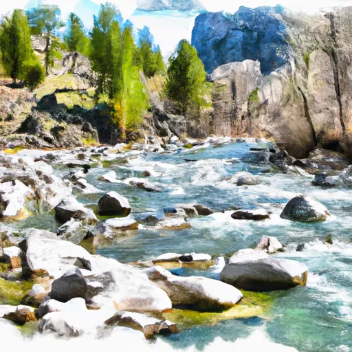
The river features several challenging rapids and obstacles, including "The Maze," "Merry-Go-Round," and "Jaws." "The Maze" is a complex section of the river with multiple channels, requiring precise navigation. "Merry-Go-Round" is a technical rapid with a tight entrance and steep drop, while "Jaws" features a large boulder that creates a powerful hydraulic.
In terms of regulations, the Middle Fork Bull River run is managed by the Kootenai National Forest. Boaters are required to obtain a permit from the Forest Service, and group size is limited to 15 people. Additionally, boaters are required to pack out all trash and follow Leave No Trace principles.
Overall, the Middle Fork Bull River run offers challenging rapids and beautiful scenery, making it a popular destination for experienced whitewater enthusiasts. It is important to research current streamflow conditions and comply with regulations to ensure a safe and enjoyable experience.
Plan your run down to the hour
Same weather feed Snoflo's iOS app uses -- updated continuously from NOAA / yr.no. Watch the precipitation column on the meteogram; rain ahead of a run typically lifts flows 12-48 hours later depending on the basin.
Next 5 days, hour by hour
Temperature line with weather symbols on top, snow + rain accumulation as columns, humidity as a dotted line.
5-day forecast table
Every 3 hours, broken out across temperature, snow, rain, humidity, and wind. Each cell is colour-coded relative to the column min/max.
| Time | Condition | Temp (°F) | Snow (in) | Rain (in) | Humidity (%) | Wind (mps) | Wind dir |
|---|---|---|---|---|---|---|---|
| Loading detailed forecast… | |||||||
15-day temperature & precipitation
Daily temperatures, snow, and rain projected over the next two weeks -- the upstream story that drives next week's flows.
Regional streamflow levels
USGS streamgauges around Middle Fork Bull River, Sec. 9, T28n, R33w To Proposed Addition To Cabinet Mtns Wilderness, Sec. 12, T28n, R33w -- useful for spotting upstream pulses and gauging which tributary is contributing what.
| Streamgauge | Discharge | View |
|---|---|---|
| Clark Fork River Below Cabinet Gorge Dam Id | 4,420 cfs | → |
| Lightning Creek At Clark Fork Id | 17 cfs | → |
| Fisher River Near Libby Mt | 94 cfs | → |
| Kootenai River Bl Libby Dam Nr Libby Mt | 9,070 cfs | → |
| Yaak River Near Troy Mt | 156 cfs | → |
| Kootenai River At Leonia Id | 9,770 cfs | → |
Plan a longer trip
The closest boat launches, other paddle runs, and campgrounds so a day on the water can grow into a full weekend.
Boat launches
Other river runs
- North Fork Bull River, Sec. 32, T29n, R32w To Proposed Cabinet Mtns Wilderness Boundary, Sec. 1, T28n, R32w
- Cabinet Mtns Wilderness Boundary, Sec. 3, T27n, R32w To Bull River, Sec. 12, T27n, R33w
- East Fork Bull River, Headwaters, Sec. 13, T27n, R32w To Cabinet Mountains Wilderness Boundary, Sec. 3, T27n, R32w
- Boundary Proposed Addition Cabinet Mtns Wilderness, Sec. To Cabinet Gorge Reservoir
- 10 Miles From Tub Gulch To Quartz Creek To 10 Miles From Tub Gulch To Quartz Creek
Whitewater safety
- Check the flow before you run
- Use the linked-gauge card and Regional Flow panel above. Class ratings change with flow -- a Class III at low water can become Class IV+ at high water.
- Know your skill ceiling
- Pick runs comfortably below your ceiling. Cold-water and big-water runs raise the consequences of any mistake.
- Wear the right gear
- Helmet, PFD, drysuit / wetsuit when water is below 60°F. Throw bag, knife, and whistle on your person, not in the boat.
- Scout, set safety, and run with a team
- Scout new rapids on foot, set safety with throw bags above the consequence pool, and run with at least one other competent paddler.
- Respect the river
- Strainers, undercuts, low-head dams, and wood can kill at any class rating. When in doubt, portage.
Set push alerts in the Snoflo app
Save Middle Fork Bull River, Sec. 9, T28n, R33w To Proposed Addition To Cabinet Mtns Wilderness, Sec. 12, T28n, R33w as a favorite, set a discharge threshold (e.g. "alert me when flow hits 600 cfs"), and the iOS app pushes the moment the linked gauge crosses.
About Middle Fork Bull River, Sec. 9, T28n, R33w To Proposed Addition To Cabinet Mtns Wilderness, Sec. 12, T28n, R33w
What's the optimal flow for Middle Fork Bull River, Sec. 9, T28n, R33w To Proposed Addition To Cabinet Mtns Wilderness, Sec. 12, T28n, R33w?
The optimal flow depends on the section and the craft. Check the Run Details panel for the linked gauge and current status.
How fresh is the cfs reading on this page?
The linked USGS streamgauge reports continuously (every 15 minutes); Snoflo refreshes throughout the day. Hover the streamflow sparkline to read individual datapoints.
What's the whitewater class?
See the Run Details panel for the class rating Snoflo tracks for this run. Class ratings change with flow -- a Class III at low water can become Class IV in high water.
Where do I put in / take out?
Tap Directions in the hero above to open driving directions to the put-in. For shuttle planning, check the Nearby Boat Launches panel and the river run operator's site.
Can I get alerts when flows hit the optimal range?
Yes -- alerts are managed in the Snoflo iOS app. Favorite this run, set a discharge threshold, and you'll get a push the moment the gauge crosses.
Other runs near here
Snoflo-tracked paddle runs within driving distance of Middle Fork Bull River, Sec. 9, T28n, R33w To Proposed Addition To Cabinet Mtns Wilderness, Sec. 12, T28n, R33w.