The Headwaters To The Confluence With Soda Butte Creek River Run
Community Reviews
Been here? Share the conditions.
Reviews, ratings & photos are added in the free Snoflo iOS app — rate a spot, tag the conditions, and your visit is verified by location. Add or manage your reviews from the app.
The Headwaters To The Confluence With Soda Butte Creek
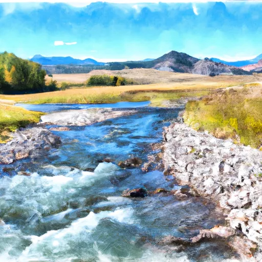
The segment mileage of the Whitewater River Run is approximately 12 miles, and it is rated as a Class III to Class IV rapids, with some Class V rapids depending on the water level. The river features a variety of obstacles and rapids, including the Big Kahuna, House Rock, and the notorious Satan's Gut.
It is important to note that this section of the river is not recommended for beginners or inexperienced paddlers. Safety precautions, such as wearing a helmet and personal flotation device, are highly recommended. Additionally, a permit is required to access the river, and camping is only allowed in designated areas.
Overall, the Whitewater River Run offers a challenging and thrilling whitewater experience for those who are up for the challenge. It is important to research the current water conditions and obtain the necessary permits before embarking on this adventure.
Plan your run down to the hour
Same weather feed Snoflo's iOS app uses -- updated continuously from NOAA / yr.no. Watch the precipitation column on the meteogram; rain ahead of a run typically lifts flows 12-48 hours later depending on the basin.
Next 5 days, hour by hour
Temperature line with weather symbols on top, snow + rain accumulation as columns, humidity as a dotted line.
5-day forecast table
Every 3 hours, broken out across temperature, snow, rain, humidity, and wind. Each cell is colour-coded relative to the column min/max.
| Time | Condition | Temp (°F) | Snow (in) | Rain (in) | Humidity (%) | Wind (mps) | Wind dir |
|---|---|---|---|---|---|---|---|
| Loading detailed forecast… | |||||||
15-day temperature & precipitation
Daily temperatures, snow, and rain projected over the next two weeks -- the upstream story that drives next week's flows.
Regional streamflow levels
USGS streamgauges around The Headwaters To The Confluence With Soda Butte Creek -- useful for spotting upstream pulses and gauging which tributary is contributing what.
| Streamgauge | Discharge | View |
|---|---|---|
| Soda Butte Cr At Park Bndry At Silver Gate | 49 cfs | → |
| North Fork Shoshone River At Wapiti | 859 cfs | → |
| Yellowstone River At Yellowstone Lk Outlet Ynp | 2,420 cfs | → |
| Lamar River Nr Tower Falls Ranger Station Ynp | 391 cfs | → |
| South Fork Shoshone River Ab Buffalo Bill Res | 641 cfs | → |
| Rock Creek Near Red Lodge Mt | 390 cfs | → |
Plan a longer trip
The closest boat launches, other paddle runs, and campgrounds so a day on the water can grow into a full weekend.
Other river runs
- Chief Joseph Cg, Sec. 28, T9s, R15e To Montana State Line, Sec. 34, T9s, R15e
- The Confluence With Soda Butte Creek To The Confluence With The Yellowstone River
- Northeast Yellowstone National Park Boundary, Near Cooke City To The Confluence With Lamar River
- North Fork Shoshone River
Fishing spots
Whitewater safety
- Check the flow before you run
- Use the linked-gauge card and Regional Flow panel above. Class ratings change with flow -- a Class III at low water can become Class IV+ at high water.
- Know your skill ceiling
- Pick runs comfortably below your ceiling. Cold-water and big-water runs raise the consequences of any mistake.
- Wear the right gear
- Helmet, PFD, drysuit / wetsuit when water is below 60°F. Throw bag, knife, and whistle on your person, not in the boat.
- Scout, set safety, and run with a team
- Scout new rapids on foot, set safety with throw bags above the consequence pool, and run with at least one other competent paddler.
- Respect the river
- Strainers, undercuts, low-head dams, and wood can kill at any class rating. When in doubt, portage.
Set push alerts in the Snoflo app
Save The Headwaters To The Confluence With Soda Butte Creek as a favorite, set a discharge threshold (e.g. "alert me when flow hits 600 cfs"), and the iOS app pushes the moment the linked gauge crosses.
About The Headwaters To The Confluence With Soda Butte Creek
What's the optimal flow for The Headwaters To The Confluence With Soda Butte Creek?
The optimal flow depends on the section and the craft. Check the Run Details panel for the linked gauge and current status.
How fresh is the cfs reading on this page?
The linked USGS streamgauge reports continuously (every 15 minutes); Snoflo refreshes throughout the day. Hover the streamflow sparkline to read individual datapoints.
What's the whitewater class?
See the Run Details panel for the class rating Snoflo tracks for this run. Class ratings change with flow -- a Class III at low water can become Class IV in high water.
Where do I put in / take out?
Tap Directions in the hero above to open driving directions to the put-in. For shuttle planning, check the Nearby Boat Launches panel and the river run operator's site.
Can I get alerts when flows hit the optimal range?
Yes -- alerts are managed in the Snoflo iOS app. Favorite this run, set a discharge threshold, and you'll get a push the moment the gauge crosses.
Other runs near here
Snoflo-tracked paddle runs within driving distance of The Headwaters To The Confluence With Soda Butte Creek.