Little North Fork And Big Creek, Sec. 32, T35n, R29w To Upstream 2 Miles River Run
Community Reviews
Been here? Share the conditions.
Reviews, ratings & photos are added in the free Snoflo iOS app — rate a spot, tag the conditions, and your visit is verified by location. Add or manage your reviews from the app.
Little North Fork And Big Creek, Sec. 32, T35n, R29w To Upstream 2 Miles
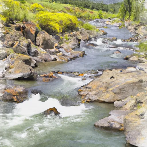
The river features several challenging rapids and obstacles, including the "S Turn," "Squeeze Play," and "Big Drop." These rapids are characterized by fast-moving water, narrow channels, and steep drops, making them exciting but also potentially dangerous. Therefore, it is recommended that paddlers have some previous whitewater experience and wear appropriate safety gear when navigating this section of the river.
There are specific regulations in place for this area, including a limit on the number of people allowed on the river at any given time. Additionally, all paddlers are required to wear personal flotation devices, and motorized boats are not allowed on the river.
Overall, the Little North Fork and Big Creek river run offers an exciting and challenging whitewater experience for intermediate paddlers. It is important to exercise caution and follow all regulations when navigating this section of the river to ensure a safe and enjoyable trip.
Plan your run down to the hour
Same weather feed Snoflo's iOS app uses -- updated continuously from NOAA / yr.no. Watch the precipitation column on the meteogram; rain ahead of a run typically lifts flows 12-48 hours later depending on the basin.
Next 5 days, hour by hour
Temperature line with weather symbols on top, snow + rain accumulation as columns, humidity as a dotted line.
5-day forecast table
Every 3 hours, broken out across temperature, snow, rain, humidity, and wind. Each cell is colour-coded relative to the column min/max.
| Time | Condition | Temp (°F) | Snow (in) | Rain (in) | Humidity (%) | Wind (mps) | Wind dir |
|---|---|---|---|---|---|---|---|
| Loading detailed forecast… | |||||||
15-day temperature & precipitation
Daily temperatures, snow, and rain projected over the next two weeks -- the upstream story that drives next week's flows.
Regional streamflow levels
USGS streamgauges around Little North Fork And Big Creek, Sec. 32, T35n, R29w To Upstream 2 Miles -- useful for spotting upstream pulses and gauging which tributary is contributing what.
| Streamgauge | Discharge | View |
|---|---|---|
| Tobacco River Near Eureka Mt | 388 cfs | → |
| Kootenai River Bl Libby Dam Nr Libby Mt | 9,010 cfs | → |
| Fisher River Near Libby Mt | 109 cfs | → |
| Yaak River Near Troy Mt | 189 cfs | → |
| Kootenai River At Leonia Id | 9,910 cfs | → |
| Kootenai River Bel Moyie River Nr Bonners Ferry Id | 10,100 cfs | → |
Plan a longer trip
The closest boat launches, other paddle runs, and campgrounds so a day on the water can grow into a full weekend.
Boat launches
- Peck Gulch Road Lincoln County
- Rocky Gorge Road Lincoln County
- Abayance Bay Marina-Rexford
- National Forest Development Road 333 Lincoln County
- Sophie Lake Road Lincoln County
- Sophie Lake
Other river runs
- Big Creek Bridge Adjacent To Lake Koocanusa, Sec. 33, T35n, R29w To North And South Fork Of Big Creek
- Good Creek And Big Creek, Sec. 26, T35n, R30w To Upstream For 2.9 Miles
- North And South Fork Of Big Creek To Upstream To Drop Creek, Sec. 29, T34n, R30w
- North Fork, Sec. 28, T35n, R30w To Upstream For 6 Miles
- Copeland Creek And South Fork, Sec. 4, T34n, R30w To Upstream 1.8 Miles
Whitewater safety
- Check the flow before you run
- Use the linked-gauge card and Regional Flow panel above. Class ratings change with flow -- a Class III at low water can become Class IV+ at high water.
- Know your skill ceiling
- Pick runs comfortably below your ceiling. Cold-water and big-water runs raise the consequences of any mistake.
- Wear the right gear
- Helmet, PFD, drysuit / wetsuit when water is below 60°F. Throw bag, knife, and whistle on your person, not in the boat.
- Scout, set safety, and run with a team
- Scout new rapids on foot, set safety with throw bags above the consequence pool, and run with at least one other competent paddler.
- Respect the river
- Strainers, undercuts, low-head dams, and wood can kill at any class rating. When in doubt, portage.
Set push alerts in the Snoflo app
Save Little North Fork And Big Creek, Sec. 32, T35n, R29w To Upstream 2 Miles as a favorite, set a discharge threshold (e.g. "alert me when flow hits 600 cfs"), and the iOS app pushes the moment the linked gauge crosses.
About Little North Fork And Big Creek, Sec. 32, T35n, R29w To Upstream 2 Miles
What's the optimal flow for Little North Fork And Big Creek, Sec. 32, T35n, R29w To Upstream 2 Miles?
The optimal flow depends on the section and the craft. Check the Run Details panel for the linked gauge and current status.
How fresh is the cfs reading on this page?
The linked USGS streamgauge reports continuously (every 15 minutes); Snoflo refreshes throughout the day. Hover the streamflow sparkline to read individual datapoints.
What's the whitewater class?
See the Run Details panel for the class rating Snoflo tracks for this run. Class ratings change with flow -- a Class III at low water can become Class IV in high water.
Where do I put in / take out?
Tap Directions in the hero above to open driving directions to the put-in. For shuttle planning, check the Nearby Boat Launches panel and the river run operator's site.
Can I get alerts when flows hit the optimal range?
Yes -- alerts are managed in the Snoflo iOS app. Favorite this run, set a discharge threshold, and you'll get a push the moment the gauge crosses.
Other runs near here
Snoflo-tracked paddle runs within driving distance of Little North Fork And Big Creek, Sec. 32, T35n, R29w To Upstream 2 Miles.