West Side Blodgett Campground, Sec. 17, T6n, R21w To Bitterroot Forest Boundary, Sec. 17, T6n, R21w River Run
Community Reviews
Been here? Share the conditions.
Reviews, ratings & photos are added in the free Snoflo iOS app — rate a spot, tag the conditions, and your visit is verified by location. Add or manage your reviews from the app.
West Side Blodgett Campground, Sec. 17, T6n, R21w To Bitterroot Forest Boundary, Sec. 17, T6n, R21w
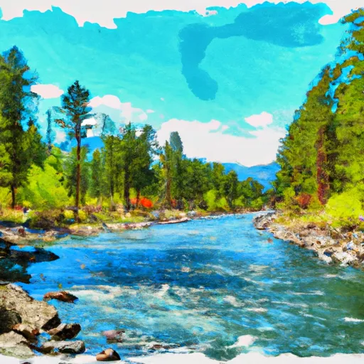
The river features several rapids, including Double Drop, Eye of the Needle, and Surprise. Double Drop is a Class III rapid with a steep drop followed by a tight, technical turn. Eye of the Needle is a Class II rapid that requires careful maneuvering through a narrow chute. Surprise is a Class III rapid that can be challenging due to its large boulders and tight passage.
It is important to note that the use of motorized equipment is prohibited on this section of the river and a permit is required for all commercial use. Additionally, all boaters must wear a personal flotation device and follow all Leave No Trace principles to protect the natural beauty of the area.
Plan your run down to the hour
Same weather feed Snoflo's iOS app uses -- updated continuously from NOAA / yr.no. Watch the precipitation column on the meteogram; rain ahead of a run typically lifts flows 12-48 hours later depending on the basin.
Next 5 days, hour by hour
Temperature line with weather symbols on top, snow + rain accumulation as columns, humidity as a dotted line.
5-day forecast table
Every 3 hours, broken out across temperature, snow, rain, humidity, and wind. Each cell is colour-coded relative to the column min/max.
| Time | Condition | Temp (°F) | Snow (in) | Rain (in) | Humidity (%) | Wind (mps) | Wind dir |
|---|---|---|---|---|---|---|---|
| Loading detailed forecast… | |||||||
15-day temperature & precipitation
Daily temperatures, snow, and rain projected over the next two weeks -- the upstream story that drives next week's flows.
Regional streamflow levels
USGS streamgauges around West Side Blodgett Campground, Sec. 17, T6n, R21w To Bitterroot Forest Boundary, Sec. 17, T6n, R21w -- useful for spotting upstream pulses and gauging which tributary is contributing what.
| Streamgauge | Discharge | View |
|---|---|---|
| Bitterroot River At Bell Crossing Nr Victor Mt | 269 cfs | → |
| Bitterroot River Near Darby Mt | 388 cfs | → |
| Middle Fork Rock Cr Nr Philipsburg Mt | 108 cfs | → |
| West Fork Bitterroot River Nr Conner Mt | 130 cfs | → |
| Bitterroot River Near Missoula Mt | 810 cfs | → |
| Rock Creek Near Clinton Mt | 423 cfs | → |
Plan a longer trip
The closest boat launches, other paddle runs, and campgrounds so a day on the water can grow into a full weekend.
Boat launches
- Woodside Bridge
- Tucker Crossing
- Old Darby Road Ravalli County
- Bell Crossing
- Lake Como Road Ravalli County
- Darby Boat Ramp
Other river runs
- S-B Boundary, Sec. 17, T6n, R21w To Westside Of Blodgett Campground, Sec. 17, T6n, R22w
- Blodgett Lake Dam, Sec. 27, T6n, R23w To S-B Wilderness Boundary, Sec. 17, T6n, R21w
- Lick Creek Bridge, Sec. 18, T4n, R21w To Bear Creek Pass, Sec. 5, T4n, R23w And Twin Lakes Dam, Sec. 29, T5n, R23w
- Trail #47 And #50, Sec. 5, T36n, R15e To Selway-Bitterroot Wilderness Boundary, Sec. 36, T36n, R15e
- No Name Creek Headwaters, Sec. 30, T10n, R22w To Mainstem, Sec. 24, T10n, R22w
Campgrounds
- Blodgett Campground
- Blodgett Canyon Campground
- Angler's Roost Rv Park
- Bitterroot Family Campground
- Lake Como
- Lake Como Campground
Fishing spots
Whitewater safety
- Check the flow before you run
- Use the linked-gauge card and Regional Flow panel above. Class ratings change with flow -- a Class III at low water can become Class IV+ at high water.
- Know your skill ceiling
- Pick runs comfortably below your ceiling. Cold-water and big-water runs raise the consequences of any mistake.
- Wear the right gear
- Helmet, PFD, drysuit / wetsuit when water is below 60°F. Throw bag, knife, and whistle on your person, not in the boat.
- Scout, set safety, and run with a team
- Scout new rapids on foot, set safety with throw bags above the consequence pool, and run with at least one other competent paddler.
- Respect the river
- Strainers, undercuts, low-head dams, and wood can kill at any class rating. When in doubt, portage.
Set push alerts in the Snoflo app
Save West Side Blodgett Campground, Sec. 17, T6n, R21w To Bitterroot Forest Boundary, Sec. 17, T6n, R21w as a favorite, set a discharge threshold (e.g. "alert me when flow hits 600 cfs"), and the iOS app pushes the moment the linked gauge crosses.
About West Side Blodgett Campground, Sec. 17, T6n, R21w To Bitterroot Forest Boundary, Sec. 17, T6n, R21w
What's the optimal flow for West Side Blodgett Campground, Sec. 17, T6n, R21w To Bitterroot Forest Boundary, Sec. 17, T6n, R21w?
The optimal flow depends on the section and the craft. Check the Run Details panel for the linked gauge and current status.
How fresh is the cfs reading on this page?
The linked USGS streamgauge reports continuously (every 15 minutes); Snoflo refreshes throughout the day. Hover the streamflow sparkline to read individual datapoints.
What's the whitewater class?
See the Run Details panel for the class rating Snoflo tracks for this run. Class ratings change with flow -- a Class III at low water can become Class IV in high water.
Where do I put in / take out?
Tap Directions in the hero above to open driving directions to the put-in. For shuttle planning, check the Nearby Boat Launches panel and the river run operator's site.
Can I get alerts when flows hit the optimal range?
Yes -- alerts are managed in the Snoflo iOS app. Favorite this run, set a discharge threshold, and you'll get a push the moment the gauge crosses.
Other runs near here
Snoflo-tracked paddle runs within driving distance of West Side Blodgett Campground, Sec. 17, T6n, R21w To Bitterroot Forest Boundary, Sec. 17, T6n, R21w.