Blackfoot River river run
Community Reviews
Been here? Share the conditions.
Reviews, ratings & photos are added in the free Snoflo iOS app — rate a spot, tag the conditions, and your visit is verified by location. Add or manage your reviews from the app.
Blackfoot River
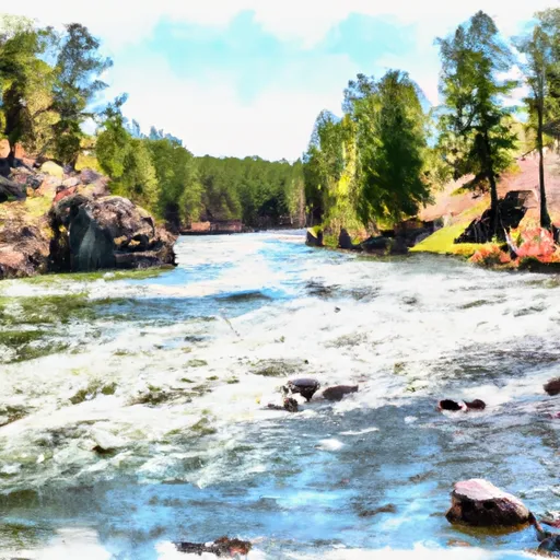
The Blackfoot River in Montana is a popular whitewater river run known for its beautiful scenery and challenging rapids. The ideal streamflow range for the Blackfoot River is between 1,000 and 3,000 cubic feet per second (cfs), with the best time for rafting being in late May through early July.
The Blackfoot River is rated as a class II-III river, which means that it has moderate to difficult rapids and obstacles that require some maneuvering and skill to navigate. The segment mileage for the Blackfoot River is approximately 24 miles, with a variety of different rapids and obstacles along the way.
One of the most significant rapids on the Blackfoot River is the Bonecrusher, a class III rapid that requires precise navigation to avoid rocks and other obstacles. Other notable rapids include Jaws, The Ledge, and The S-Turn.
There are specific regulations and guidelines for rafting on the Blackfoot River, including restrictions on the types of boats and equipment that can be used, as well as requirements for wearing personal flotation devices (PFDs) and other safety gear. Additionally, there are designated access points and parking areas along the river that must be used to ensure that the river remains safe and accessible for all users.
Overall, the Blackfoot River is a challenging and exciting whitewater river run that offers both beautiful scenery and thrilling rapids for experienced rafters. With the right equipment and preparation, it is an excellent destination for anyone looking for an adventure on the water.
Plan your run down to the hour
Same weather feed Snoflo's iOS app uses -- updated continuously from NOAA / yr.no. Watch the precipitation column on the meteogram; rain ahead of a run typically lifts flows 12-48 hours later depending on the basin.
Next 5 days, hour by hour
Temperature line with weather symbols on top, snow + rain accumulation as columns, humidity as a dotted line.
5-day forecast table
Every 3 hours, broken out across temperature, snow, rain, humidity, and wind. Each cell is colour-coded relative to the column min/max.
| Time | Condition | Temp (°F) | Snow (in) | Rain (in) | Humidity (%) | Wind (mps) | Wind dir |
|---|---|---|---|---|---|---|---|
| Loading detailed forecast… | |||||||
15-day temperature & precipitation
Daily temperatures, snow, and rain projected over the next two weeks -- the upstream story that drives next week's flows.
Regional streamflow levels
USGS streamgauges around Blackfoot River -- useful for spotting upstream pulses and gauging which tributary is contributing what.
| Streamgauge | Discharge | View |
|---|---|---|
| Blackfoot River Near Bonner Mt | 1,470 cfs | → |
| Clark Fork At Turah Bridge Nr Bonner Mt | 1,210 cfs | → |
| Clark Fork Above Missoula Mt | 2,700 cfs | → |
| Rock Creek Near Clinton Mt | 618 cfs | → |
| South Fork Jocko River Near Arlee Mt | 73 cfs | → |
| Bitterroot River Near Missoula Mt | 1,930 cfs | → |
Plan a longer trip
The closest boat launches, other paddle runs, and campgrounds so a day on the water can grow into a full weekend.
Boat launches
- Whitaker Boat Launch
- Whitaker Bridge Day Use
- Johnsrud Boat Launch
- Corrick's River Bend
- Mt 200 10495, Missoula County
- Turah
Campgrounds
- Thibodeau Campground
- Thibodeau Fas
- Johnsrud Park Fas
- Corricks River Bend Fas
- Ninemile Prairie Fas
- Clearwater Crossing
Fishing spots
Whitewater safety
- Check the flow before you run
- Use the linked-gauge card and Regional Flow panel above. Class ratings change with flow -- a Class III at low water can become Class IV+ at high water.
- Know your skill ceiling
- Pick runs comfortably below your ceiling. Cold-water and big-water runs raise the consequences of any mistake.
- Wear the right gear
- Helmet, PFD, drysuit / wetsuit when water is below 60°F. Throw bag, knife, and whistle on your person, not in the boat.
- Scout, set safety, and run with a team
- Scout new rapids on foot, set safety with throw bags above the consequence pool, and run with at least one other competent paddler.
- Respect the river
- Strainers, undercuts, low-head dams, and wood can kill at any class rating. When in doubt, portage.
Set push alerts in the Snoflo app
Save Blackfoot River as a favorite, set a discharge threshold (e.g. "alert me when flow hits 600 cfs"), and the iOS app pushes the moment the linked gauge crosses.
About Blackfoot River
What's the optimal flow for Blackfoot River?
The optimal flow depends on the section and the craft. Check the Run Details panel for the linked gauge and current status.
How fresh is the cfs reading on this page?
The linked USGS streamgauge reports continuously (every 15 minutes); Snoflo refreshes throughout the day. Hover the streamflow sparkline to read individual datapoints.
What's the whitewater class?
See the Run Details panel for the class rating Snoflo tracks for this run. Class ratings change with flow -- a Class III at low water can become Class IV in high water.
Where do I put in / take out?
Tap Directions in the hero above to open driving directions to the put-in. For shuttle planning, check the Nearby Boat Launches panel and the river run operator's site.
Can I get alerts when flows hit the optimal range?
Yes -- alerts are managed in the Snoflo iOS app. Favorite this run, set a discharge threshold, and you'll get a push the moment the gauge crosses.
Other runs near here
Snoflo-tracked paddle runs within driving distance of Blackfoot River.