Headwaters To Nf Boundary River Run
Community Reviews
Been here? Share the conditions.
Reviews, ratings & photos are added in the free Snoflo iOS app — rate a spot, tag the conditions, and your visit is verified by location. Add or manage your reviews from the app.
Headwaters To Nf Boundary
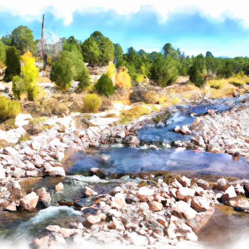
There are several rapids and obstacles that paddlers will encounter on this run, including the Headwaters Rapid, Corner Pocket, and the Narrows. These rapids require skill and experience to maneuver safely. Paddlers should be aware of potential hazards such as undercut rocks, strainers, and strong currents.
There are specific regulations that apply to this area, including permit requirements for commercial outfitters and guidelines for private boaters. Paddlers should also follow Leave No Trace principles and respect private property along the riverbank.
Overall, the Whitewater River run Headwaters to NF Boundary offers thrilling whitewater rapids and scenic views of the surrounding wilderness. Paddlers should carefully evaluate their skills and experience before attempting this run, and always take appropriate safety precautions.
Plan your run down to the hour
Same weather feed Snoflo's iOS app uses -- updated continuously from NOAA / yr.no. Watch the precipitation column on the meteogram; rain ahead of a run typically lifts flows 12-48 hours later depending on the basin.
Next 5 days, hour by hour
Temperature line with weather symbols on top, snow + rain accumulation as columns, humidity as a dotted line.
5-day forecast table
Every 3 hours, broken out across temperature, snow, rain, humidity, and wind. Each cell is colour-coded relative to the column min/max.
| Time | Condition | Temp (°F) | Snow (in) | Rain (in) | Humidity (%) | Wind (mps) | Wind dir |
|---|---|---|---|---|---|---|---|
| Loading detailed forecast… | |||||||
15-day temperature & precipitation
Daily temperatures, snow, and rain projected over the next two weeks -- the upstream story that drives next week's flows.
Regional streamflow levels
USGS streamgauges around Headwaters To Nf Boundary -- useful for spotting upstream pulses and gauging which tributary is contributing what.
| Streamgauge | Discharge | View |
|---|---|---|
| Rio San Jose Near Grants | 2 cfs | → |
| Arroyo Chico Nr Guadalupe | · | → |
| Rio Puerco Abv Arroyo Chico Nr Guadalupe | 2 cfs | → |
| Rio Nutria Near Ramah | 0 cfs | → |
| Zuni River Abv Black Rock Reservoir | 0 cfs | → |
| Rio Grande At Albuquerque | 376 cfs | → |
Plan a longer trip
The closest boat launches, other paddle runs, and campgrounds so a day on the water can grow into a full weekend.
Other river runs
- Bluewater Creek
- Headwaters (Off Continental Divide) To Nf Boundary With Private Land
- Nf Boundary With Silva Ranch To The East To Nf Boundary With Tnc To The South
- Below Ellis Ranch To Private Land Boundary
- Headwaters To Nf Boundary (To Eastern Parcel Of Forest Valley Subdivision)
Whitewater safety
- Check the flow before you run
- Use the linked-gauge card and Regional Flow panel above. Class ratings change with flow -- a Class III at low water can become Class IV+ at high water.
- Know your skill ceiling
- Pick runs comfortably below your ceiling. Cold-water and big-water runs raise the consequences of any mistake.
- Wear the right gear
- Helmet, PFD, drysuit / wetsuit when water is below 60°F. Throw bag, knife, and whistle on your person, not in the boat.
- Scout, set safety, and run with a team
- Scout new rapids on foot, set safety with throw bags above the consequence pool, and run with at least one other competent paddler.
- Respect the river
- Strainers, undercuts, low-head dams, and wood can kill at any class rating. When in doubt, portage.
Set push alerts in the Snoflo app
Save Headwaters To Nf Boundary as a favorite, set a discharge threshold (e.g. "alert me when flow hits 600 cfs"), and the iOS app pushes the moment the linked gauge crosses.
About Headwaters To Nf Boundary
What's the optimal flow for Headwaters To Nf Boundary?
The optimal flow depends on the section and the craft. Check the Run Details panel for the linked gauge and current status.
How fresh is the cfs reading on this page?
The linked USGS streamgauge reports continuously (every 15 minutes); Snoflo refreshes throughout the day. Hover the streamflow sparkline to read individual datapoints.
What's the whitewater class?
See the Run Details panel for the class rating Snoflo tracks for this run. Class ratings change with flow -- a Class III at low water can become Class IV in high water.
Where do I put in / take out?
Tap Directions in the hero above to open driving directions to the put-in. For shuttle planning, check the Nearby Boat Launches panel and the river run operator's site.
Can I get alerts when flows hit the optimal range?
Yes -- alerts are managed in the Snoflo iOS app. Favorite this run, set a discharge threshold, and you'll get a push the moment the gauge crosses.
Other runs near here
Snoflo-tracked paddle runs within driving distance of Headwaters To Nf Boundary.