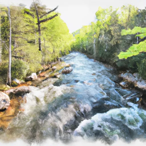
Dark Prong From Headwaters To Confluence East Fork And Yellowstone Prong River Run
Community Reviews
Been here? Share the conditions.
Reviews, ratings & photos are added in the free Snoflo iOS app — rate a spot, tag the conditions, and your visit is verified by location. Add or manage your reviews from the app.
Dark Prong From Headwaters To Confluence East Fork And Yellowstone Prong
The Dark Prong run is subject to some specific regulations. Visitors are required to obtain a permit from the Great Smoky Mountains National Park. The park has strict rules regarding camping, fires, and waste disposal. Visitors are advised to follow the Leave No Trace principle and minimize their impact on the environment.
In summary, Dark Prong is a challenging and exciting river run that attracts experienced kayakers and whitewater enthusiasts from all over. With a beautiful landscape and varied rapids, it offers an unforgettable experience for anyone willing to take on the challenge. It is important to adhere to all regulations and guidelines to protect the environment and ensure everyone's safety.
Plan your run down to the hour
Same weather feed Snoflo's iOS app uses -- updated continuously from NOAA / yr.no. Watch the precipitation column on the meteogram; rain ahead of a run typically lifts flows 12-48 hours later depending on the basin.
Next 5 days, hour by hour
Temperature line with weather symbols on top, snow + rain accumulation as columns, humidity as a dotted line.
5-day forecast table
Every 3 hours, broken out across temperature, snow, rain, humidity, and wind. Each cell is colour-coded relative to the column min/max.
| Time | Condition | Temp (°F) | Snow (in) | Rain (in) | Humidity (%) | Wind (mps) | Wind dir |
|---|---|---|---|---|---|---|---|
| Loading detailed forecast… | |||||||
15-day temperature & precipitation
Daily temperatures, snow, and rain projected over the next two weeks -- the upstream story that drives next week's flows.
Regional streamflow levels
USGS streamgauges around Dark Prong From Headwaters To Confluence East Fork And Yellowstone Prong -- useful for spotting upstream pulses and gauging which tributary is contributing what.
| Streamgauge | Discharge | View |
|---|---|---|
| W F Pigeon R Above Lake Logan Nr Hazelwood | 92 cfs | → |
| Davidson River Near Brevard | 75 cfs | → |
| West Fork Pigeon River Near Retreat | 36 cfs | → |
| East Fork Pigeon River Near Canton | 99 cfs | → |
| W Fk Pigeon R At Bethel | 100 cfs | → |
| French Broad River At Blantyre | 425 cfs | → |
Plan a longer trip
The closest boat launches, other paddle runs, and campgrounds so a day on the water can grow into a full weekend.
Boat launches
Other river runs
- Yellowstone Prong From Headwaters To Confluence With East Fork And Yellowstone Prong
- East Fork From Us Highway 276 To Confluence Of Dark Prong And Yellowstone Prong
- South Fork From Confluence With Pigeon Br To Nf Boundary
- North Fork From Bottom Of Spillway Of Hendersonville Reservoir To Confluence With South Fork
- Nf Boundary To Confluence With North Fork
Campgrounds
- Cove Creek Group Campground
- Shining Rock Campground
- Deep Gap Shelter
- Ch-2
- Butter Gap Shelter
- White Pines Group Campground
Fishing spots
Whitewater safety
- Check the flow before you run
- Use the linked-gauge card and Regional Flow panel above. Class ratings change with flow -- a Class III at low water can become Class IV+ at high water.
- Know your skill ceiling
- Pick runs comfortably below your ceiling. Cold-water and big-water runs raise the consequences of any mistake.
- Wear the right gear
- Helmet, PFD, drysuit / wetsuit when water is below 60°F. Throw bag, knife, and whistle on your person, not in the boat.
- Scout, set safety, and run with a team
- Scout new rapids on foot, set safety with throw bags above the consequence pool, and run with at least one other competent paddler.
- Respect the river
- Strainers, undercuts, low-head dams, and wood can kill at any class rating. When in doubt, portage.
Set push alerts in the Snoflo app
Save Dark Prong From Headwaters To Confluence East Fork And Yellowstone Prong as a favorite, set a discharge threshold (e.g. "alert me when flow hits 600 cfs"), and the iOS app pushes the moment the linked gauge crosses.
About Dark Prong From Headwaters To Confluence East Fork And Yellowstone Prong
What's the optimal flow for Dark Prong From Headwaters To Confluence East Fork And Yellowstone Prong?
The optimal flow depends on the section and the craft. Check the Run Details panel for the linked gauge and current status.
How fresh is the cfs reading on this page?
The linked USGS streamgauge reports continuously (every 15 minutes); Snoflo refreshes throughout the day. Hover the streamflow sparkline to read individual datapoints.
What's the whitewater class?
See the Run Details panel for the class rating Snoflo tracks for this run. Class ratings change with flow -- a Class III at low water can become Class IV in high water.
Where do I put in / take out?
Tap Directions in the hero above to open driving directions to the put-in. For shuttle planning, check the Nearby Boat Launches panel and the river run operator's site.
Can I get alerts when flows hit the optimal range?
Yes -- alerts are managed in the Snoflo iOS app. Favorite this run, set a discharge threshold, and you'll get a push the moment the gauge crosses.
Other runs near here
Snoflo-tracked paddle runs within driving distance of Dark Prong From Headwaters To Confluence East Fork And Yellowstone Prong.