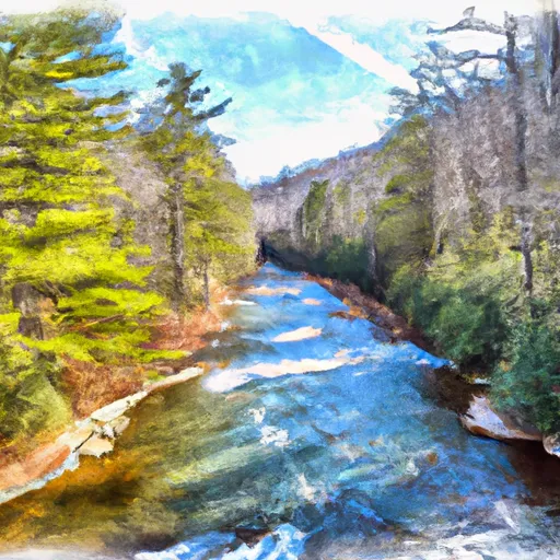
East Fork From Us Highway 276 To Confluence Of Dark Prong And Yellowstone Prong River Run
Community Reviews
Been here? Share the conditions.
Reviews, ratings & photos are added in the free Snoflo iOS app — rate a spot, tag the conditions, and your visit is verified by location. Add or manage your reviews from the app.
East Fork From Us Highway 276 To Confluence Of Dark Prong And Yellowstone Prong
The East Fork section of the Whitewater River is regulated by the United States Forest Service. There are no specific regulations regarding boating or fishing within this section of the river, but visitors are expected to follow Leave No Trace principles and pack out all trash. Additionally, the Forest Service may close the river to boating during periods of high water or drought.
Overall, the East Fork section of the Whitewater River offers a challenging and exciting run for experienced paddlers. It is important to note that water levels can change quickly and occasionally there can be hazards such as downed trees in the river, so visitors should exercise caution and be prepared for changing conditions.
Plan your run down to the hour
Same weather feed Snoflo's iOS app uses -- updated continuously from NOAA / yr.no. Watch the precipitation column on the meteogram; rain ahead of a run typically lifts flows 12-48 hours later depending on the basin.
Next 5 days, hour by hour
Temperature line with weather symbols on top, snow + rain accumulation as columns, humidity as a dotted line.
5-day forecast table
Every 3 hours, broken out across temperature, snow, rain, humidity, and wind. Each cell is colour-coded relative to the column min/max.
| Time | Condition | Temp (°F) | Snow (in) | Rain (in) | Humidity (%) | Wind (mps) | Wind dir |
|---|---|---|---|---|---|---|---|
| Loading detailed forecast… | |||||||
15-day temperature & precipitation
Daily temperatures, snow, and rain projected over the next two weeks -- the upstream story that drives next week's flows.
Regional streamflow levels
USGS streamgauges around East Fork From Us Highway 276 To Confluence Of Dark Prong And Yellowstone Prong -- useful for spotting upstream pulses and gauging which tributary is contributing what.
| Streamgauge | Discharge | View |
|---|---|---|
| W F Pigeon R Above Lake Logan Nr Hazelwood | 30 cfs | → |
| West Fork Pigeon River Near Retreat | 36 cfs | → |
| East Fork Pigeon River Near Canton | 65 cfs | → |
| W Fk Pigeon R At Bethel | 54 cfs | → |
| Davidson River Near Brevard | 47 cfs | → |
| Pigeon River Near Canton | 163 cfs | → |
Plan a longer trip
The closest boat launches, other paddle runs, and campgrounds so a day on the water can grow into a full weekend.
Boat launches
- Pisgah Forest Access Brevard
- Penrose
- Horse Shoe
- Canada Road 14091, Tuckasegee
- North Lakeshore Drive 103, Haywood County
Other river runs
- Dark Prong From Headwaters To Confluence East Fork And Yellowstone Prong
- Yellowstone Prong From Headwaters To Confluence With East Fork And Yellowstone Prong
- South Fork From Confluence With Pigeon Br To Nf Boundary
- Nf Boundary To Confluence With North Fork
- North Fork From Bottom Of Spillway Of Hendersonville Reservoir To Confluence With South Fork
Campgrounds
- Shining Rock Campground
- Mt Pisgah
- Riverside Campground
- Mount Pisgah Campground
- Thompson Creek Camp Site
- Mount Pisgah - Blue Ridge Parkway
Fishing spots
Whitewater safety
- Check the flow before you run
- Use the linked-gauge card and Regional Flow panel above. Class ratings change with flow -- a Class III at low water can become Class IV+ at high water.
- Know your skill ceiling
- Pick runs comfortably below your ceiling. Cold-water and big-water runs raise the consequences of any mistake.
- Wear the right gear
- Helmet, PFD, drysuit / wetsuit when water is below 60°F. Throw bag, knife, and whistle on your person, not in the boat.
- Scout, set safety, and run with a team
- Scout new rapids on foot, set safety with throw bags above the consequence pool, and run with at least one other competent paddler.
- Respect the river
- Strainers, undercuts, low-head dams, and wood can kill at any class rating. When in doubt, portage.
Set push alerts in the Snoflo app
Save East Fork From Us Highway 276 To Confluence Of Dark Prong And Yellowstone Prong as a favorite, set a discharge threshold (e.g. "alert me when flow hits 600 cfs"), and the iOS app pushes the moment the linked gauge crosses.
About East Fork From Us Highway 276 To Confluence Of Dark Prong And Yellowstone Prong
What's the optimal flow for East Fork From Us Highway 276 To Confluence Of Dark Prong And Yellowstone Prong?
The optimal flow depends on the section and the craft. Check the Run Details panel for the linked gauge and current status.
How fresh is the cfs reading on this page?
The linked USGS streamgauge reports continuously (every 15 minutes); Snoflo refreshes throughout the day. Hover the streamflow sparkline to read individual datapoints.
What's the whitewater class?
See the Run Details panel for the class rating Snoflo tracks for this run. Class ratings change with flow -- a Class III at low water can become Class IV in high water.
Where do I put in / take out?
Tap Directions in the hero above to open driving directions to the put-in. For shuttle planning, check the Nearby Boat Launches panel and the river run operator's site.
Can I get alerts when flows hit the optimal range?
Yes -- alerts are managed in the Snoflo iOS app. Favorite this run, set a discharge threshold, and you'll get a push the moment the gauge crosses.
Other runs near here
Snoflo-tracked paddle runs within driving distance of East Fork From Us Highway 276 To Confluence Of Dark Prong And Yellowstone Prong.