Confluence Of North And South Forks To Headwaters Of South Fork River Run
Community Reviews
Been here? Share the conditions.
Reviews, ratings & photos are added in the free Snoflo iOS app — rate a spot, tag the conditions, and your visit is verified by location. Add or manage your reviews from the app.
Confluence Of North And South Forks To Headwaters Of South Fork
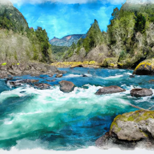
The segment mileage for this run is approximately 14 miles, starting at the confluence of the North and South Forks and ending at the headwaters of the South Fork. Along the way, paddlers will encounter stunning scenery, including old-growth forests and steep canyon walls.
It is important to note that there are specific regulations in place for this area. The Whitewater River is part of the Mount Hood National Forest, and visitors are required to follow all park rules, including proper waste disposal and fire safety. Additionally, permits may be required for camping or parking in certain areas.
Overall, the Whitewater River run is a thrilling adventure for experienced paddlers who are up for a challenge. While it is important to follow regulations and safety guidelines, the rewards of this scenic river run are well worth the effort.
Plan your run down to the hour
Same weather feed Snoflo's iOS app uses -- updated continuously from NOAA / yr.no. Watch the precipitation column on the meteogram; rain ahead of a run typically lifts flows 12-48 hours later depending on the basin.
Next 5 days, hour by hour
Temperature line with weather symbols on top, snow + rain accumulation as columns, humidity as a dotted line.
5-day forecast table
Every 3 hours, broken out across temperature, snow, rain, humidity, and wind. Each cell is colour-coded relative to the column min/max.
| Time | Condition | Temp (°F) | Snow (in) | Rain (in) | Humidity (%) | Wind (mps) | Wind dir |
|---|---|---|---|---|---|---|---|
| Loading detailed forecast… | |||||||
15-day temperature & precipitation
Daily temperatures, snow, and rain projected over the next two weeks -- the upstream story that drives next week's flows.
Regional streamflow levels
USGS streamgauges around Confluence Of North And South Forks To Headwaters Of South Fork -- useful for spotting upstream pulses and gauging which tributary is contributing what.
| Streamgauge | Discharge | View |
|---|---|---|
| Coast Fork Willamette R Blw Cottage Grove Dam | 50 cfs | → |
| Row River Near Cottage Grove | 107 cfs | → |
| Row River Above Pitcher Creek Near | 29 cfs | → |
| Coast Fork Willamette River Near Goshen | 149 cfs | → |
| Middle Fork Willamette River Near Dexter | 1,720 cfs | → |
| Middle Fork Willamette River At Jasper | 2,140 cfs | → |
Plan a longer trip
The closest boat launches, other paddle runs, and campgrounds so a day on the water can grow into a full weekend.
Boat launches
Other river runs
- Confluence Of North And South Forks To Headwaters Of North Fork
- Siuslaw Falls To Confluence Of North And South Forks
- Siuslaw River Seg B
- Clay Creek Campground To Siuslaw Falls
- Wildcat Creek Launch Site To Clay Creek Campground
Campgrounds
- Pass Creek County Park
- Primitive - Cottage Grove Lake
- Pine Meadows- Cottage Grove Lake
- Schwarz
- Baker Bay Park
- Rice Hill Rv Park
Whitewater safety
- Check the flow before you run
- Use the linked-gauge card and Regional Flow panel above. Class ratings change with flow -- a Class III at low water can become Class IV+ at high water.
- Know your skill ceiling
- Pick runs comfortably below your ceiling. Cold-water and big-water runs raise the consequences of any mistake.
- Wear the right gear
- Helmet, PFD, drysuit / wetsuit when water is below 60°F. Throw bag, knife, and whistle on your person, not in the boat.
- Scout, set safety, and run with a team
- Scout new rapids on foot, set safety with throw bags above the consequence pool, and run with at least one other competent paddler.
- Respect the river
- Strainers, undercuts, low-head dams, and wood can kill at any class rating. When in doubt, portage.
Set push alerts in the Snoflo app
Save Confluence Of North And South Forks To Headwaters Of South Fork as a favorite, set a discharge threshold (e.g. "alert me when flow hits 600 cfs"), and the iOS app pushes the moment the linked gauge crosses.
About Confluence Of North And South Forks To Headwaters Of South Fork
What's the optimal flow for Confluence Of North And South Forks To Headwaters Of South Fork?
The optimal flow depends on the section and the craft. Check the Run Details panel for the linked gauge and current status.
How fresh is the cfs reading on this page?
The linked USGS streamgauge reports continuously (every 15 minutes); Snoflo refreshes throughout the day. Hover the streamflow sparkline to read individual datapoints.
What's the whitewater class?
See the Run Details panel for the class rating Snoflo tracks for this run. Class ratings change with flow -- a Class III at low water can become Class IV in high water.
Where do I put in / take out?
Tap Directions in the hero above to open driving directions to the put-in. For shuttle planning, check the Nearby Boat Launches panel and the river run operator's site.
Can I get alerts when flows hit the optimal range?
Yes -- alerts are managed in the Snoflo iOS app. Favorite this run, set a discharge threshold, and you'll get a push the moment the gauge crosses.
Other runs near here
Snoflo-tracked paddle runs within driving distance of Confluence Of North And South Forks To Headwaters Of South Fork.