Mill Site To Center Bridge River Run
Community Reviews
Been here? Share the conditions.
Reviews, ratings & photos are added in the free Snoflo iOS app — rate a spot, tag the conditions, and your visit is verified by location. Add or manage your reviews from the app.
Mill Site To Center Bridge
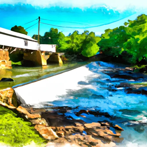
The segment mileage for the Whitewater River Run Mill Site To Center Bridge is approximately 5 miles. This section of river is known for its challenging rapids and obstacles, including Double Drop, Big Pillow, and Roostertail. These rapids require skilled maneuvering and quick thinking to navigate successfully.
When visiting this section of the river, it is important to be aware of specific regulations. The use of alcohol and drugs is strictly prohibited, and all participants must wear personal flotation devices (PFDs) at all times. Additionally, visitors are not allowed to leave any trash or litter along the river.
Overall, the Whitewater River Run Mill Site To Center Bridge is a thrilling and challenging stretch of river that offers experienced paddlers a challenging adventure. It is important to be aware of the ideal streamflow range, class rating, segment mileage, specific rapids/obstacles, and regulations when planning a trip to this area.
Plan your run down to the hour
Same weather feed Snoflo's iOS app uses -- updated continuously from NOAA / yr.no. Watch the precipitation column on the meteogram; rain ahead of a run typically lifts flows 12-48 hours later depending on the basin.
Next 5 days, hour by hour
Temperature line with weather symbols on top, snow + rain accumulation as columns, humidity as a dotted line.
5-day forecast table
Every 3 hours, broken out across temperature, snow, rain, humidity, and wind. Each cell is colour-coded relative to the column min/max.
| Time | Condition | Temp (°F) | Snow (in) | Rain (in) | Humidity (%) | Wind (mps) | Wind dir |
|---|---|---|---|---|---|---|---|
| Loading detailed forecast… | |||||||
15-day temperature & precipitation
Daily temperatures, snow, and rain projected over the next two weeks -- the upstream story that drives next week's flows.
Regional streamflow levels
USGS streamgauges around Mill Site To Center Bridge -- useful for spotting upstream pulses and gauging which tributary is contributing what.
| Streamgauge | Discharge | View |
|---|---|---|
| Daddys Creek Near Hebbertsburg | 25 cfs | → |
| Sewee Creek Near Decatur | 117 cfs | → |
| Clear Creek At Lilly Bridge Near Lancing | 85 cfs | → |
| Obed River Near Lancing | 183 cfs | → |
| Emory River At Oakdale | 358 cfs | → |
| Calfkiller River At Hwy 111 Below Sparta | 282 cfs | → |
Plan a longer trip
The closest boat launches, other paddle runs, and campgrounds so a day on the water can grow into a full weekend.
Boat launches
- Lake Tansi Marina
- Meadow Park Lake
- Roddy
- Rhea Harbor
- Whites Creek Marina & Lakeside Resort
- Spring City Boat Dock
Other river runs
- Center Bridge To Cumberland-Morgan County Line
- I-40 Bridge To Western Boundary Of Catoosa Wildlife Management Area, At Adams Bridge
- U.S. 127 Bridge To Morgan County Line
- Apalachia Powerhouse (Rm 53.5) To Us411 Bridge (Rm 43.0)
- Tn/Nc State Line (Rm 48.0) To Tn360 Bridge (Rm 30.0)
Whitewater safety
- Check the flow before you run
- Use the linked-gauge card and Regional Flow panel above. Class ratings change with flow -- a Class III at low water can become Class IV+ at high water.
- Know your skill ceiling
- Pick runs comfortably below your ceiling. Cold-water and big-water runs raise the consequences of any mistake.
- Wear the right gear
- Helmet, PFD, drysuit / wetsuit when water is below 60°F. Throw bag, knife, and whistle on your person, not in the boat.
- Scout, set safety, and run with a team
- Scout new rapids on foot, set safety with throw bags above the consequence pool, and run with at least one other competent paddler.
- Respect the river
- Strainers, undercuts, low-head dams, and wood can kill at any class rating. When in doubt, portage.
Set push alerts in the Snoflo app
Save Mill Site To Center Bridge as a favorite, set a discharge threshold (e.g. "alert me when flow hits 600 cfs"), and the iOS app pushes the moment the linked gauge crosses.
About Mill Site To Center Bridge
What's the optimal flow for Mill Site To Center Bridge?
The optimal flow depends on the section and the craft. Check the Run Details panel for the linked gauge and current status.
How fresh is the cfs reading on this page?
The linked USGS streamgauge reports continuously (every 15 minutes); Snoflo refreshes throughout the day. Hover the streamflow sparkline to read individual datapoints.
What's the whitewater class?
See the Run Details panel for the class rating Snoflo tracks for this run. Class ratings change with flow -- a Class III at low water can become Class IV in high water.
Where do I put in / take out?
Tap Directions in the hero above to open driving directions to the put-in. For shuttle planning, check the Nearby Boat Launches panel and the river run operator's site.
Can I get alerts when flows hit the optimal range?
Yes -- alerts are managed in the Snoflo iOS app. Favorite this run, set a discharge threshold, and you'll get a push the moment the gauge crosses.
Other runs near here
Snoflo-tracked paddle runs within driving distance of Mill Site To Center Bridge.