Top Of Cascade Springs To Road Crossing In Section 36 River Run
Community Reviews
Been here? Share the conditions.
Reviews, ratings & photos are added in the free Snoflo iOS app — rate a spot, tag the conditions, and your visit is verified by location. Add or manage your reviews from the app.
Top Of Cascade Springs To Road Crossing In Section 36
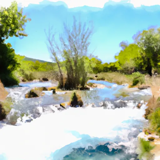
The segment mileage for this run is approximately 4 miles, with several notable rapids and obstacles along the way. The first major rapid is called "The Squeeze," which is a narrow chute with a large boulder blocking the way. Other rapids include "The Bend" and "The Wall," which require careful maneuvering through turbulent waters.
In terms of regulations, all boaters must have a valid Utah state boating permit and must wear a personal flotation device at all times. It is also recommended to have a guide or experienced boater in the group, as this section can be challenging and unpredictable. Additionally, the area is managed by the Uinta-Wasatch-Cache National Forest, so visitors must adhere to all park regulations and practice Leave No Trace principles.
Plan your run down to the hour
Same weather feed Snoflo's iOS app uses -- updated continuously from NOAA / yr.no. Watch the precipitation column on the meteogram; rain ahead of a run typically lifts flows 12-48 hours later depending on the basin.
Next 5 days, hour by hour
Temperature line with weather symbols on top, snow + rain accumulation as columns, humidity as a dotted line.
5-day forecast table
Every 3 hours, broken out across temperature, snow, rain, humidity, and wind. Each cell is colour-coded relative to the column min/max.
| Time | Condition | Temp (°F) | Snow (in) | Rain (in) | Humidity (%) | Wind (mps) | Wind dir |
|---|---|---|---|---|---|---|---|
| Loading detailed forecast… | |||||||
15-day temperature & precipitation
Daily temperatures, snow, and rain projected over the next two weeks -- the upstream story that drives next week's flows.
Regional streamflow levels
USGS streamgauges around Top Of Cascade Springs To Road Crossing In Section 36 -- useful for spotting upstream pulses and gauging which tributary is contributing what.
| Streamgauge | Discharge | View |
|---|---|---|
| Daniels Creek At Charleston | · | → |
| Snake Creek Near Charleston | 23 cfs | → |
| Provo River Near Charleston | 226 cfs | → |
| American Fk Ab Upper Powerplant Nr American Fk | 18 cfs | → |
| Provo River At River Road Bridge | 194 cfs | → |
| Provo River At Provo | 49 cfs | → |
Plan a longer trip
The closest boat launches, other paddle runs, and campgrounds so a day on the water can grow into a full weekend.
Boat launches
- State Route 314 Wasatch County
- Deer Creek Island
- Deer Creek State Park- Charleston Day Use Area
- Lindon Boat Harbor
- North Vineyard Road 4888, Vineyard
- American Fork Boat Harbor
Other river runs
- Mt Timpanogos Wilderness Boundary To Theater-In-The-Pines
- Headwater Spring In Sec 8 To Mt Timpanogos Wilderness Boundary
- Mt Timpanogos Wilderenss Boundary To Scout Falls
- Confluence Below Timpooneke To Mt Timpanogos Wilderness Boundary
- Bridal Veil (Bv)
Campgrounds
- Deer Creek State Park
- Mt. Timpanogos
- Theater-In-The-Pines Campground
- Mount Timpanogos Campground
- Altamont Group Campground
- Site 2
Fishing spots
Whitewater safety
- Check the flow before you run
- Use the linked-gauge card and Regional Flow panel above. Class ratings change with flow -- a Class III at low water can become Class IV+ at high water.
- Know your skill ceiling
- Pick runs comfortably below your ceiling. Cold-water and big-water runs raise the consequences of any mistake.
- Wear the right gear
- Helmet, PFD, drysuit / wetsuit when water is below 60°F. Throw bag, knife, and whistle on your person, not in the boat.
- Scout, set safety, and run with a team
- Scout new rapids on foot, set safety with throw bags above the consequence pool, and run with at least one other competent paddler.
- Respect the river
- Strainers, undercuts, low-head dams, and wood can kill at any class rating. When in doubt, portage.
Set push alerts in the Snoflo app
Save Top Of Cascade Springs To Road Crossing In Section 36 as a favorite, set a discharge threshold (e.g. "alert me when flow hits 600 cfs"), and the iOS app pushes the moment the linked gauge crosses.
About Top Of Cascade Springs To Road Crossing In Section 36
What's the optimal flow for Top Of Cascade Springs To Road Crossing In Section 36?
The optimal flow depends on the section and the craft. Check the Run Details panel for the linked gauge and current status.
How fresh is the cfs reading on this page?
The linked USGS streamgauge reports continuously (every 15 minutes); Snoflo refreshes throughout the day. Hover the streamflow sparkline to read individual datapoints.
What's the whitewater class?
See the Run Details panel for the class rating Snoflo tracks for this run. Class ratings change with flow -- a Class III at low water can become Class IV in high water.
Where do I put in / take out?
Tap Directions in the hero above to open driving directions to the put-in. For shuttle planning, check the Nearby Boat Launches panel and the river run operator's site.
Can I get alerts when flows hit the optimal range?
Yes -- alerts are managed in the Snoflo iOS app. Favorite this run, set a discharge threshold, and you'll get a push the moment the gauge crosses.
Other runs near here
Snoflo-tracked paddle runs within driving distance of Top Of Cascade Springs To Road Crossing In Section 36.