Dolores River Segment 1 River Run
Community Reviews
Been here? Share the conditions.
Reviews, ratings & photos are added in the free Snoflo iOS app — rate a spot, tag the conditions, and your visit is verified by location. Add or manage your reviews from the app.
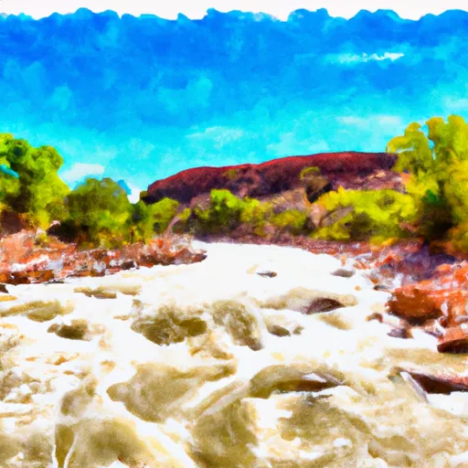
Dolores River Segment 1
The ideal streamflow range for this segment is between 500 and 1,200 cfs. At lower flows, the rapids are less challenging and require more maneuvering, while at higher flows, the rapids become more powerful and technical.
The segment is home to several notable rapids, including Snaggletooth, Stateline, and Slickrock. These rapids feature large waves, steep drops, and technical maneuvers that require precise paddling skills.
In addition to the challenging rapids, paddlers must also be aware of specific regulations in the area. The Dolores River is managed by the Bureau of Land Management (BLM), and permits are required for overnight camping and river access. Additionally, paddlers must follow Leave No Trace principles and pack out all trash and waste.
Overall, the Dolores River Segment 1 is a thrilling whitewater river run that offers challenging rapids and stunning scenery. However, it is important for paddlers to have previous experience and follow all regulations to ensure a safe and enjoyable trip.
Plan your run down to the hour
Same weather feed Snoflo's iOS app uses -- updated continuously from NOAA / yr.no. Watch the precipitation column on the meteogram; rain ahead of a run typically lifts flows 12-48 hours later depending on the basin.
Next 5 days, hour by hour
Temperature line with weather symbols on top, snow + rain accumulation as columns, humidity as a dotted line.
5-day forecast table
Every 3 hours, broken out across temperature, snow, rain, humidity, and wind. Each cell is colour-coded relative to the column min/max.
| Time | Condition | Temp (°F) | Snow (in) | Rain (in) | Humidity (%) | Wind (mps) | Wind dir |
|---|---|---|---|---|---|---|---|
| Loading detailed forecast… | |||||||
15-day temperature & precipitation
Daily temperatures, snow, and rain projected over the next two weeks -- the upstream story that drives next week's flows.
Regional streamflow levels
USGS streamgauges around Dolores River Segment 1 -- useful for spotting upstream pulses and gauging which tributary is contributing what.
| Streamgauge | Discharge | View |
|---|---|---|
| Dolores River Near Cisco | 32 cfs | → |
| Colorado River Near Cisco | 1,610 cfs | → |
| Dolores River Near Gateway | 17 cfs | → |
| Castle Creek Below Castle Valley Near Moab | 4 cfs | → |
| Mill Creek At Sheley Tunnel | 3 cfs | → |
| Mill Creek Below Sheley Tunnel | 3 cfs | → |
Plan a longer trip
The closest boat launches, other paddle runs, and campgrounds so a day on the water can grow into a full weekend.
Boat launches
- Ut 128 Moab
- Hittle Bottom Recreation Site
- Dewey Bridge Recreation Site
- Grand County
- Lower Onion Creek Boat Ramp
- Fisher Towers Road Grand County
Other river runs
- Fisher Creek, Dolores River Segment 1
- Beaver Creek
- Fisher Creek
- Granite Creek, Dolores River Segment 2
- Dolores River Segment 2
Campgrounds
- Hideout Canyon Camping Area
- Cowskin Campground
- Cowskin Camping Area
- Designated Campsite
- Fisher Towers Recreation Site
Fishing spots
Whitewater safety
- Check the flow before you run
- Use the linked-gauge card and Regional Flow panel above. Class ratings change with flow -- a Class III at low water can become Class IV+ at high water.
- Know your skill ceiling
- Pick runs comfortably below your ceiling. Cold-water and big-water runs raise the consequences of any mistake.
- Wear the right gear
- Helmet, PFD, drysuit / wetsuit when water is below 60°F. Throw bag, knife, and whistle on your person, not in the boat.
- Scout, set safety, and run with a team
- Scout new rapids on foot, set safety with throw bags above the consequence pool, and run with at least one other competent paddler.
- Respect the river
- Strainers, undercuts, low-head dams, and wood can kill at any class rating. When in doubt, portage.
Set push alerts in the Snoflo app
Save Dolores River Segment 1 as a favorite, set a discharge threshold (e.g. "alert me when flow hits 600 cfs"), and the iOS app pushes the moment the linked gauge crosses.
About Dolores River Segment 1
What's the optimal flow for Dolores River Segment 1?
The optimal flow depends on the section and the craft. Check the Run Details panel for the linked gauge and current status.
How fresh is the cfs reading on this page?
The linked USGS streamgauge reports continuously (every 15 minutes); Snoflo refreshes throughout the day. Hover the streamflow sparkline to read individual datapoints.
What's the whitewater class?
See the Run Details panel for the class rating Snoflo tracks for this run. Class ratings change with flow -- a Class III at low water can become Class IV in high water.
Where do I put in / take out?
Tap Directions in the hero above to open driving directions to the put-in. For shuttle planning, check the Nearby Boat Launches panel and the river run operator's site.
Can I get alerts when flows hit the optimal range?
Yes -- alerts are managed in the Snoflo iOS app. Favorite this run, set a discharge threshold, and you'll get a push the moment the gauge crosses.
Other runs near here
Snoflo-tracked paddle runs within driving distance of Dolores River Segment 1.