.5 Mile Above Route 22 To Us 33 River Run
Community Reviews
Been here? Share the conditions.
Reviews, ratings & photos are added in the free Snoflo iOS app — rate a spot, tag the conditions, and your visit is verified by location. Add or manage your reviews from the app.
.5 Mile Above Route 22 To Us 33
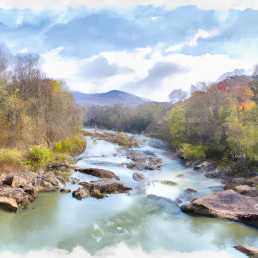
The river rapids and obstacles include Boulder Garden, a series of large boulders that create exciting drops and waves, and the Staircase, a challenging series of rapids that require precise navigation. Paddlers should also be aware of the tight turns and strainers that can make the run more challenging.
In terms of regulations, the Whitewater River Run is managed by the Monongahela National Forest and is subject to their rules and regulations. Paddlers must have a valid permit to access the river, and camping is only permitted in designated areas. There are also restrictions on motorized vehicles and equipment, to preserve the natural beauty of the area.
Overall, the Whitewater River Run is a thrilling and challenging experience for advanced paddlers, with exciting rapids and beautiful scenery. It is important to be aware of the ideal streamflow range, class rating, specific river rapids/obstacles, and regulations of the area before embarking on this adventure.
Plan your run down to the hour
Same weather feed Snoflo's iOS app uses -- updated continuously from NOAA / yr.no. Watch the precipitation column on the meteogram; rain ahead of a run typically lifts flows 12-48 hours later depending on the basin.
Next 5 days, hour by hour
Temperature line with weather symbols on top, snow + rain accumulation as columns, humidity as a dotted line.
5-day forecast table
Every 3 hours, broken out across temperature, snow, rain, humidity, and wind. Each cell is colour-coded relative to the column min/max.
| Time | Condition | Temp (°F) | Snow (in) | Rain (in) | Humidity (%) | Wind (mps) | Wind dir |
|---|---|---|---|---|---|---|---|
| Loading detailed forecast… | |||||||
15-day temperature & precipitation
Daily temperatures, snow, and rain projected over the next two weeks -- the upstream story that drives next week's flows.
Regional streamflow levels
USGS streamgauges around .5 Mile Above Route 22 To Us 33 -- useful for spotting upstream pulses and gauging which tributary is contributing what.
| Streamgauge | Discharge | View |
|---|---|---|
| Shavers Fork Below Bowden | 175 cfs | → |
| Tygart Valley River Near Dailey | 106 cfs | → |
| Dry Fork At Hendricks | 347 cfs | → |
| Cheat River Near Parsons | 965 cfs | → |
| Tygart Valley River At Belington | 337 cfs | → |
| Blackwater R At Davis | 107 cfs | → |
Plan a longer trip
The closest boat launches, other paddle runs, and campgrounds so a day on the water can grow into a full weekend.
Boat launches
Other river runs
- Frazier Creek To .5 Mile Above Us 33
- ,5 Mile Above Us 33 To Waterfall Run
- Forks To Frazier Creek
- .5 North Of Us 33 To Shears Hollow
- Mcgee Run To .5 Mile Above Route 22
Campgrounds
- Bear Heaven Campground
- Stuart Day Use Area And Campground
- Stuart Campground
- Casa Vitela
- Cooper's Campground
- Pegasus Farm Campground
Whitewater safety
- Check the flow before you run
- Use the linked-gauge card and Regional Flow panel above. Class ratings change with flow -- a Class III at low water can become Class IV+ at high water.
- Know your skill ceiling
- Pick runs comfortably below your ceiling. Cold-water and big-water runs raise the consequences of any mistake.
- Wear the right gear
- Helmet, PFD, drysuit / wetsuit when water is below 60°F. Throw bag, knife, and whistle on your person, not in the boat.
- Scout, set safety, and run with a team
- Scout new rapids on foot, set safety with throw bags above the consequence pool, and run with at least one other competent paddler.
- Respect the river
- Strainers, undercuts, low-head dams, and wood can kill at any class rating. When in doubt, portage.
Set push alerts in the Snoflo app
Save .5 Mile Above Route 22 To Us 33 as a favorite, set a discharge threshold (e.g. "alert me when flow hits 600 cfs"), and the iOS app pushes the moment the linked gauge crosses.
About .5 Mile Above Route 22 To Us 33
What's the optimal flow for .5 Mile Above Route 22 To Us 33?
The optimal flow depends on the section and the craft. Check the Run Details panel for the linked gauge and current status.
How fresh is the cfs reading on this page?
The linked USGS streamgauge reports continuously (every 15 minutes); Snoflo refreshes throughout the day. Hover the streamflow sparkline to read individual datapoints.
What's the whitewater class?
See the Run Details panel for the class rating Snoflo tracks for this run. Class ratings change with flow -- a Class III at low water can become Class IV in high water.
Where do I put in / take out?
Tap Directions in the hero above to open driving directions to the put-in. For shuttle planning, check the Nearby Boat Launches panel and the river run operator's site.
Can I get alerts when flows hit the optimal range?
Yes -- alerts are managed in the Snoflo iOS app. Favorite this run, set a discharge threshold, and you'll get a push the moment the gauge crosses.
Other runs near here
Snoflo-tracked paddle runs within driving distance of .5 Mile Above Route 22 To Us 33.