Waddells Mill Pond Dam Dam

Waddells Mill Pond Dam
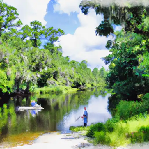
Waddells Mill Pond Dam, located in Jackson, Florida, is a privately owned earth dam primarily used for recreational purposes. Standing at a height of 10 feet and stretching 1200 feet in length, this dam impounds the Waddells Mill Pond and provides a storage capacity of 3135 acre-feet. The dam's surface area covers approximately 127 acres, offering a picturesque setting for outdoor activities such as fishing, boating, and wildlife observation.
While the dam's hazard potential is currently labeled as 'Undetermined' and its condition assessment is 'Not Rated', it is reassuring to know that the state of Florida regulates, inspects, and enforces safety measures on this structure. The dam is situated within the jurisdiction of the state, with permitting and inspection procedures in place to ensure its continued safe operation. As the dam does not fall under the ownership or funding of federal agencies, maintenance and management responsibilities lie with the private owner.
With its tranquil waters and surrounding natural beauty, Waddells Mill Pond Dam provides a valuable recreational resource for the local community and visitors alike. Its importance extends beyond leisure activities, serving as a vital component of the area's ecosystem and water resource management. As climate change continues to impact water resources, understanding and safeguarding structures like Waddells Mill Pond Dam becomes increasingly crucial in ensuring sustainable water conservation and adaptation to shifting environmental conditions.
Plan around the weather
Same NOAA / yr.no feed Snoflo's iOS app uses. Watch the precipitation column on the meteogram -- rain on the basin upstream typically lifts inflow 24-72 hours later.
Next 5 days, hour by hour
Temperature line with weather symbols on top, snow + rain accumulation as columns, humidity as a dotted line.
5-day forecast table
Every 3 hours, broken out across temperature, snow, rain, humidity, and wind. Each cell is colour-coded relative to the column min/max.
| Time | Condition | Temp (°F) | Snow (in) | Rain (in) | Humidity (%) | Wind (mps) | Wind dir |
|---|---|---|---|---|---|---|---|
| Loading detailed forecast… | |||||||
15-day temperature & precipitation
Daily temperatures, snow, and rain projected over the next two weeks.
Nearby streamflow gauges
USGS streamgauges around Waddells Mill Pond Dam -- inflows here typically show up in storage 24-72 hours later.
| Streamgauge | Discharge | View |
|---|---|---|
| Chipola River At Marianna Fl | 600 cfs | → |
| Chipola River Nr Altha | 1,040 cfs | → |
| Wrights Creek At Sh 177-A Nr Bonifay | 89 cfs | → |
| Sawhatchee Creek At Cedar Springs | 47 cfs | → |
| Holmes Creek At Vernon | 501 cfs | → |
| Apalachicola River At Chattahoochee Fla | 10,600 cfs | → |


About Waddells Mill Pond Dam
Where does the data for Waddells Mill Pond Dam come from?
Structural and regulatory data come from the U.S. Army Corps of Engineers' National Inventory of Dams (NID). Weather forecast comes from NOAA / yr.no -- the same feed Snoflo's iOS app uses.
How often is the report updated?
NID structural data refreshes annually as the Corps publishes updated assessments. The weather forecast refreshes throughout the day.
What does the Undetermined hazard rating mean?
The Corps of Engineers' hazard potential classification grades probable consequences if the dam fails: High = probable loss of human life; Significant = no probable loss of human life but possible economic loss / environmental damage; Low = no probable loss of human life, only minor economic / environmental losses. See the Dam Data Reference card below for the full definitions.
What's "% of normal"?
The current storage value compared to the historical average storage on this calendar day. 100% = right on average; values above 100% mean above-normal storage (wet year); values below mean below-normal (dry year or drought).
Can I get alerts when storage crosses a threshold?
Yes -- alerts are managed in the Snoflo iOS app. Favorite this dam, set a threshold, and you'll get a push the moment conditions cross.
Dam data reference
Condition Assessment
- Satisfactory
- No existing or potential dam safety deficiencies are recognized. Acceptable performance is expected under all loading conditions (static, hydrologic, seismic) in accordance with the minimum applicable state or federal regulatory criteria or tolerable risk guidelines.
- Fair
- No existing dam safety deficiencies are recognized for normal operating conditions. Rare or extreme hydrologic and/or seismic events may result in a dam safety deficiency. Risk may be in the range to take further action.
- Poor
- A dam safety deficiency is recognized for normal operating conditions which may realistically occur. Remedial action is necessary. POOR may also be used when uncertainties exist as to critical analysis parameters which identify a potential dam safety deficiency.
- Unsatisfactory
- A dam safety deficiency is recognized that requires immediate or emergency remedial action for problem resolution.
- Not Rated
- The dam has not been inspected, is not under state or federal jurisdiction, or has been inspected but, for whatever reason, has not been rated.
Hazard Potential Classification
- High
- Dams assigned the high hazard potential classification are those where failure or mis-operation will probably cause loss of human life.
- Significant
- Dams assigned the significant hazard potential classification are those dams where failure or mis-operation results in no probable loss of human life but can cause economic loss, environmental damage, disruption of lifeline facilities, or impact other concerns. Significant hazard potential classification dams are often located in predominantly rural or agricultural areas but could be in areas with population and significant infrastructure.
- Low
- Dams assigned the low hazard potential classification are those where failure or mis-operation results in no probable loss of human life and low economic and/or environmental losses. Losses are principally limited to the owner's property.
- Undetermined
- Dams for which a downstream hazard potential has not been designated or is not provided.