


Cow Branch Slurry Impoundment Reservoir Report
Last Updated: May 3, 2026
°F
°F
mph
Wind
%
Humidity
Cow Branch Slurry Impoundment, located in Kimper, Pike County, Kentucky, is a private dam primarily used for tailings storage.
Summary
This earthen dam stands at an impressive height of 442 feet and has a storage capacity of 3,674 acre-feet. While the dam is not regulated by the state of Kentucky, it falls under the jurisdiction of the Mine Safety and Health Administration, with inspections conducted by the same agency.
With a hazard potential classified as "high," the condition assessment of Cow Branch Slurry Impoundment is currently listed as "Not Available." Despite the lack of detailed information on its condition, this large-scale dam poses a significant risk in the event of a failure. Emergency action plans, risk assessments, and inundation maps are also lacking for this structure, raising concerns about its preparedness for potential disasters. It is crucial for stakeholders and regulators to prioritize the safety and maintenance of this dam to mitigate any potential risks to surrounding communities and the environment.
Regional Streamflow Levels
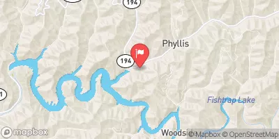 Grapevine Creek Near Phyllis
|
2cfs |
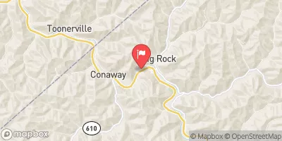 Levisa Fork At Big Rock
|
104cfs |
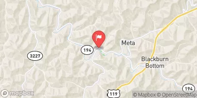 Johns Creek Near Meta
|
15cfs |
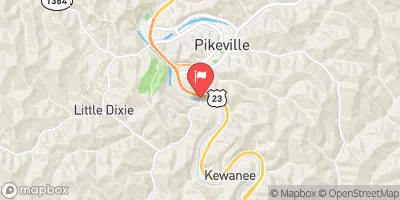 Levisa Fork At Pikeville
|
261cfs |
 Tug Fork At Williamson
|
353cfs |
 Russell Fork At Bartlick
|
1060cfs |
15-Day Long Term Forecast
Dam Length |
1600 |
Dam Height |
442 |
Primary Dam Type |
Earth |
Nid Storage |
3674 |
Hazard Potential |
High |
Nid Height |
442 |
Seasonal Comparison
5-Day Hourly Forecast Detail
Dam Data Reference
Condition Assessment
SatisfactoryNo existing or potential dam safety deficiencies are recognized. Acceptable performance is expected under all loading conditions (static, hydrologic, seismic) in accordance with the minimum applicable state or federal regulatory criteria or tolerable risk guidelines.
Fair
No existing dam safety deficiencies are recognized for normal operating conditions. Rare or extreme hydrologic and/or seismic events may result in a dam safety deficiency. Risk may be in the range to take further action. Note: Rare or extreme event is defined by the regulatory agency based on their minimum
Poor A dam safety deficiency is recognized for normal operating conditions which may realistically occur. Remedial action is necessary. POOR may also be used when uncertainties exist as to critical analysis parameters which identify a potential dam safety deficiency. Investigations and studies are necessary.
Unsatisfactory
A dam safety deficiency is recognized that requires immediate or emergency remedial action for problem resolution.
Not Rated
The dam has not been inspected, is not under state or federal jurisdiction, or has been inspected but, for whatever reason, has not been rated.
Not Available
Dams for which the condition assessment is restricted to approved government users.
Hazard Potential Classification
HighDams assigned the high hazard potential classification are those where failure or mis-operation will probably cause loss of human life.
Significant
Dams assigned the significant hazard potential classification are those dams where failure or mis-operation results in no probable loss of human life but can cause economic loss, environment damage, disruption of lifeline facilities, or impact other concerns. Significant hazard potential classification dams are often located in predominantly rural or agricultural areas but could be in areas with population and significant infrastructure.
Low
Dams assigned the low hazard potential classification are those where failure or mis-operation results in no probable loss of human life and low economic and/or environmental losses. Losses are principally limited to the owner's property.
Undetermined
Dams for which a downstream hazard potential has not been designated or is not provided.
Not Available
Dams for which the downstream hazard potential is restricted to approved government users.
Area Campgrounds
 Grapevine - Fishtrap Lake
 Hatfield’s Hideout Riverfront Cabins and Campground
 Breaks InterState Park
 Lower Twin Branch - John W. Flannagan Reservoir
 Mullins Pond Campsite
 Pound River - John W. Flannagan Reservoir
 Mud River At Palermo
River Runs
-
 Confluence Of White Branch With Russell Fork (And 1 Mile Upstream On Pound River) To Railroad Bridge Crossing Above Elkhorn City
-
 State Route 72 Bridge To Confluence With Clinch River
-
 Confluence With Guest River To Confluence With Little Stony Creek
-
 Fs Route 700 To Confluence With Clinch River
-
 Headwaters To Alternative Route 58