Highway 76 26439, Santa Ysabel Boat Launch
Community Reviews
Been here? Share the conditions.
Reviews, ratings & photos are added in the free Snoflo iOS app — rate a spot, tag the conditions, and your visit is verified by location. Add or manage your reviews from the app.
Highway 76 26439, Santa Ysabel
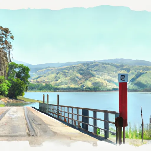
The boat ramp on Lake Henshaw is a concrete ramp and is approximately 20 feet wide. It services Lake Henshaw, which is a reservoir in San Diego County, California. The lake is approximately 1,140 acres and is open to fishing, boating, and other recreational activities.
According to the California Department of Fish and Wildlife, all types of watercraft are permitted on Lake Henshaw, including motorized boats and personal watercraft. However, there are some restrictions on the use of motorized boats, such as a 35 mph speed limit and a requirement for a California boating safety certificate for operators under the age of 36. It is important for boaters to check the latest regulations and safety requirements before using the boat ramp and watercraft on Lake Henshaw.
Plan your launch down to the hour
Same weather feed Snoflo's iOS app uses -- updated continuously from NOAA / yr.no.
Next 5 days, hour by hour
Temperature line with weather symbols on top, snow + rain accumulation as columns, humidity as a dotted line.
5-day forecast table
Every 3 hours, broken out across temperature, snow, rain, humidity, and wind.
| Time | Condition | Temp (°F) | Snow (in) | Rain (in) | Humidity (%) | Wind (mps) | Wind dir |
|---|---|---|---|---|---|---|---|
| Loading detailed forecast… | |||||||
15-day temperature & precipitation
Daily temperatures, snow, and rain projected over the next two weeks.
Area streamflow levels
USGS streamgauges around Highway 76 26439, Santa Ysabel -- the same readings that determine whether your launch is safe and your boat is the right craft.
| Streamgauge | Discharge | View |
|---|---|---|
| Santa Ysabel C Nr Ramona Ca | · | → |
| Guejito C Nr San Pasqual Ca | 0 cfs | → |
| Santa Maria C Nr Ramona Ca | · | → |
| Temecula C Nr Aguanga Ca | · | → |
| Santa Margarita R Nr Temecula Ca | 3 cfs | → |
| Rainbow C Nr Fallbrook Ca | 0 cfs | → |
Plan a longer trip
The closest paddle runs, fishing spots, and other boat launches so you can extend a day on the water.
River runs
- Forest Boundary, Above Zoo Creek Below Spillway (S1/2, Sec 3, T11s, R2e) To La Jolla Indian Reservation Boundary (N1/2, Sec 31, T10s, R2e)
- Confluence Of Fry And Iron Spring Creeks (E1/2, Sec 3, T10s,R1e To Se1/4 Sec 16, T10s, R2e
- Santa Margarita River
- Crouch Ranch To Morena Reservoir
- Palm Canyon
Nearby fishing
Boating safety & etiquette
- Check the conditions before you launch
- Use the streamflow numbers, weather, and wind forecast on this page. High-cfs whitewater requires whitewater-specific craft and skill.
- Wear your life jacket
- Statistically the single biggest survival factor in a boating incident. State law often requires one per passenger.
- File a float plan
- Tell someone on shore your put-in, take-out, and expected return time. Especially for multi-day or remote trips.
- Yield at the ramp
- Prep gear in the parking lot, not on the ramp. Launch and clear quickly so others can use the lane.
- Clean, drain, dry
- Inspect, clean, drain and dry your boat between waters to prevent the spread of aquatic invasive species.
Set push alerts in the Snoflo app
Save Highway 76 26439, Santa Ysabel as a favorite, set a discharge threshold or a wind/precipitation alert, and the iOS app will push the moment conditions cross.
About Highway 76 26439, Santa Ysabel
Can I launch a motorboat here?
Most Snoflo-tracked launches support motorboats; check the operator for any horsepower restrictions, paddle-only zones, or seasonal closures.
How fresh is the streamflow data?
USGS streamgauges report continuously (every 15 minutes); the table on this page pulls the latest reading at page load.
Is there a fee?
Many federal and state boat launches charge a day-use fee. Check the operator's site before driving out.
What boat is right for these conditions?
Use the nearby streamflow numbers and river-run panel on this page to gauge current conditions. Wider, slower water is friendly for casual paddling and powerboats; high-cfs whitewater requires whitewater-specific craft and skill.
Can I get alerts when conditions change?
Yes -- alerts are managed in the Snoflo iOS app. Favorite this launch, set a threshold (discharge, wind), and you'll get a push the moment it crosses.
Other launches near here
Snoflo-tracked boat launches within driving distance of Highway 76 26439, Santa Ysabel.