Pigeon Point Campground
Community Reviews
Been here? Share the conditions.
Reviews, ratings & photos are added in the free Snoflo iOS app — rate a spot, tag the conditions, and your visit is verified by location. Add or manage your reviews from the app.
Pigeon Point
Reservations are accepted at Pigeon Point camping area, ensuring campers can secure a spot ahead of time. This is particularly useful during the peak season when the campground tends to fill up quickly. It is recommended to make reservations well in advance to guarantee a spot, especially if planning a visit during the summer months.
The best time to visit Pigeon Point camping area is during the summer and early fall, as the weather is usually mild and pleasant during these months. However, it is advised to check the weather forecast before visiting, as the area can experience occasional fog and cool temperatures.
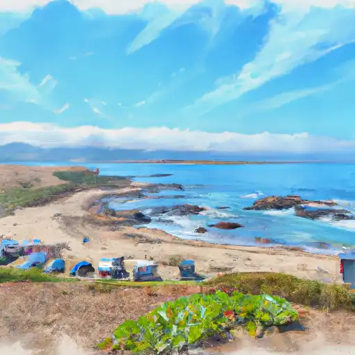
The camping area is adjacent to the beautiful Pigeon Point Lighthouse, a historic landmark that offers stunning coastal views. Visitors can explore the lighthouse and its surroundings, learn about its history, and even spot migrating whales during certain times of the year. However, it is important to exercise caution when venturing near the cliffs as they can be steep and dangerous. Additionally, campers should be mindful of the strong ocean currents when swimming or engaging in water activities along the nearby shoreline.
What's on-site at Pigeon Point
Key facilities Snoflo tracks for this campground. Confirm with the operator before booking -- amenities can change seasonally.
Plan your trip down to the hour
Same weather feed Snoflo's iOS app uses -- updated continuously from NOAA / yr.no.
Next 5 days, hour by hour
Temperature line with weather symbols on top, snow + rain accumulation as columns, humidity as a dotted line.
5-day forecast table
Every 3 hours, broken out across temperature, snow, rain, humidity, and wind. Each cell is colour-coded relative to the column min/max so trends jump out at a glance.
| Time | Condition | Temp (°F) | Snow (in) | Rain (in) | Humidity (%) | Wind (mps) | Wind dir |
|---|---|---|---|---|---|---|---|
| Loading detailed forecast… | |||||||
15-day temperature & precipitation
Daily temperatures, snow, and rain projected over the next two weeks. Hover any point for the full breakdown.
Other campgrounds in the area
Snoflo-tracked campsites within driving distance of Pigeon Point, with reservations status.
| Campground | Reservations | Toilets | View |
|---|---|---|---|
| Thistle Glade | ✗ | ✗ | → |
| Lower Nye Campground | ✓ | ✗ | → |
| Lower Nye Campgrounds | ✗ | ✗ | → |
| Lower Nye | ✗ | ✗ | → |
| Bear Ckeek Equestrian Campground | ✗ | ✗ | → |
| Sunset Point - Lake Pillsbury | ✗ | ✓ | → |
Nearby streamflow
USGS streamgauges within reach of Pigeon Point -- pulled live from the National Water Information System.
| Streamgauge | Discharge | View |
|---|---|---|
| Ef Russian R Nr Calpella Ca | 30 cfs | → |
| Nf Cache C A Hough Spring Nr Clearlake Oaks Ca | 31 cfs | → |
| Ef Russian R Nr Ukiah Ca | 156 cfs | → |
| Russian R Nr Ukiah Ca | 0 cfs | → |
| Outlet C Nr Willits Ca | 4 cfs | → |
| Russian R Nr Talmage Ca | 107 cfs | → |
Plan a longer trip
The closest parks, lakes, boat launches, and paddle runs so a camping night can grow into a full weekend.
Parks
- Wilderness Trinity Alps
- Lowden Park
- Klamath National Forest
- Wilderness Chanchelulla
- Whiskeytown-Shasta-Trinity National Recreation Area
- Wilderness Russian
Boat launches
- Lake Pillsbury Resort Marina
- Fuller Grove Boat
- H.V. Keeling County Park
- Tally's Family Resort
- Lake Mendocino Recreation Park, Inc.
- Lucerne Harbor County Park
Fishing spots
- Lake Pillsbury
- East Park Reservoir
- Lake Mendocino
- Clear Lake (Lake Cty)
- Cameron's Fishing Hole Catch & Release
- Black Butte Lake
Points of interest
- Lopes Cabin
- Seabiscuit's Grave And Statue
- Lake County Courthouse Museum
- Grace Hudson Museum
- Corner Gallery
- Sun House
Paddle runs
- Headwaters In Sec 28, T18n, R8w To One-Third Mile Beyond Snow Mt. Wilderness Boundary At Private Property Boundary Near Paradise Creek
- Elk Creek
- North Fork Cache Creek
- Deep Hole Creek
- Private Land In Sec 1, T21n, R9w To Confluence Of Cold Creek And Black Butte River
- Fish Creek
Camping essentials & Leave No Trace
- Pack it in, pack it out
- Take all trash, food scraps, and gear back with you to keep campsites clean and protect wildlife.
- Respect wildlife
- Observe animals from a distance, store food securely, and never feed wildlife to maintain natural behavior and safety.
- Know before you go
- Check weather, fire restrictions, trail conditions, and permit requirements to ensure a safe and well-planned trip.
- Minimize campfire impact
- Use established fire rings, keep fires small, fully extinguish them, or opt for a camp stove when fires are restricted.
- Leave what you find
- Preserve natural and cultural features by avoiding removal of plants, rocks, artifacts, or other elements of the environment.
Set push alerts in the Snoflo app
Save Pigeon Point as a favorite, set a custom threshold (precipitation, snowpack, freezing temperatures), and the iOS app will push the moment conditions cross.
About Pigeon Point
Can I make reservations at Pigeon Point?
This campground does not appear to accept reservations -- it's typically first-come, first-served. Arrive early on summer weekends.
How fresh is the weather data on this page?
The hourly forecast updates throughout the day from the NOAA / yr.no public feeds. Streamflow data is pulled live from USGS streamgauges and snowpack from the NRCS SNOTEL network.
What's the best time of year to visit?
Use the 15-day temperature & precipitation outlook on this page to plan -- pick a window with comfortable temperatures and low precipitation. For longer trips, the 5-day hourly meteogram shows snow + rain accumulation hour-by-hour.
How do I get to Pigeon Point?
Tap Directions in the hero above to open driving directions in Google Maps, or Open in map to center the Snoflo interactive map on the campground.
Can I get alerts when conditions change?
Yes -- alerts are managed through the Snoflo iOS app. Favorite this campground, set a threshold (temperature, snowpack, precipitation), and you'll get a push the moment it crosses.
Other campgrounds near here
Snoflo-tracked campgrounds within driving distance of Pigeon Point.