Stubblefield Canyon Campground
Community Reviews
Been here? Share the conditions.
Reviews, ratings & photos are added in the free Snoflo iOS app — rate a spot, tag the conditions, and your visit is verified by location. Add or manage your reviews from the app.
Stubblefield Canyon
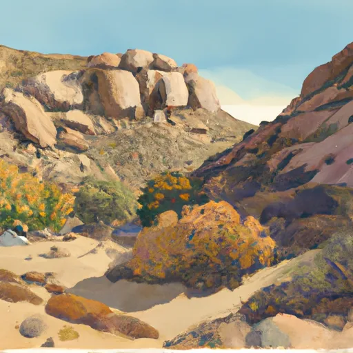
Reservations are not accepted at Stubblefield Canyon camping area, and campsites are available on a first-come, first-served basis. It is advisable to arrive early, especially during weekends and peak seasons, to secure a spot. The best time to visit this camping area is during the spring and fall months when temperatures are more moderate and the natural beauty of the surrounding landscape is at its peak.
While exploring this camping area, campers should be cautious of the rugged terrain, as well as the potential presence of wildlife like bears or rattlesnakes. It is important to adhere to all safety guidelines provided by park authorities and properly store food to avoid attracting animals. Additionally, campers should be aware of fire restrictions and always practice fire safety measures to prevent wildfires.
In summary, Stubblefield Canyon camping area in California offers a rustic camping experience with basic amenities such as pit toilets, fire rings, and picnic tables. Reservations are not accepted, and the best time to visit is during the spring and fall. Campers should be cautious of the rugged terrain, wildlife, and adhere to fire safety guidelines.
What's on-site at Stubblefield Canyon
Key facilities Snoflo tracks for this campground. Confirm with the operator before booking -- amenities can change seasonally.
Plan your trip down to the hour
Same weather feed Snoflo's iOS app uses -- updated continuously from NOAA / yr.no.
Next 5 days, hour by hour
Temperature line with weather symbols on top, snow + rain accumulation as columns, humidity as a dotted line.
5-day forecast table
Every 3 hours, broken out across temperature, snow, rain, humidity, and wind. Each cell is colour-coded relative to the column min/max so trends jump out at a glance.
| Time | Condition | Temp (°F) | Snow (in) | Rain (in) | Humidity (%) | Wind (mps) | Wind dir |
|---|---|---|---|---|---|---|---|
| Loading detailed forecast… | |||||||
15-day temperature & precipitation
Daily temperatures, snow, and rain projected over the next two weeks. Hover any point for the full breakdown.
Other campgrounds in the area
Snoflo-tracked campsites within driving distance of Stubblefield Canyon, with reservations status.
| Campground | Reservations | Toilets | View |
|---|---|---|---|
| Benson Lake | ✗ | ✗ | → |
| Dorothy Lake | ✗ | ✗ | → |
| Sheep Camp | ✗ | ✗ | → |
| White Wolf - Yosemite National Park | ✗ | ✓ | → |
| Hetch Hetchy Backpackers Camp | ✗ | ✗ | → |
Nearby streamflow
USGS streamgauges within reach of Stubblefield Canyon -- pulled live from the National Water Information System.
| Streamgauge | Discharge | View |
|---|---|---|
| Tuolumne R A Grand Cyn Of Tuolumne Ab Hetch Hetchy | 149 cfs | → |
| Tuolumne R Nr Hetch Hetchy Ca | 114 cfs | → |
| Robinson C At Twin Lks Outlet Nr Bridgeport | 97 cfs | → |
| Lk Eleanor Div To Cherry Lake Nr Hetch Hetchy Ca | 1 cfs | → |
| Eleanor C Nr Hetch Hetchy Ca | 22 cfs | → |
| Cherry C Bl Valley Dam Nr Hetch Hetchy Ca | 13 cfs | → |
Nearby snow depths
NRCS SNOTEL stations within reach of Stubblefield Canyon -- relevant when planning a shoulder-season or alpine trip.
| SNOTEL station | Snowpack | 24h Snowfall | View |
|---|---|---|---|
| Nohrsc Paradise Meadow | 0.0 in | 0.0 in | → |
| Nohrsc Horse Meadows | 0.0 in | 0.0 in | → |
| Nohrsc White Wolf Raws | 0.1 in | 0.0 in | → |
| Nohrsc Leavitt Lake | 0.0 in | 0.0 in | → |
| Leavitt Lake | 0.0 in | 0.0 in | → |
| Nohrsc Lower Kibbie | 0.0 in | 0.0 in | → |
Plan a longer trip
The closest parks, lakes, boat launches, and paddle runs so a camping night can grow into a full weekend.
Parks
- Wilderness Emigrant
- Hoover Wilderness
- Toiyabe National Forest
- Mono Lake Tufa State Reserve
- Wilderness Carson-Iceberg
- Wildlife Area Slinkard / Little Antelope
Boat launches
- Annett's Mono Village Fishing Resort
- Forest Route 1n04, Groveland
- Lundy Lake
- Pinecrest Lake Resort Marina
Fishing spots
Points of interest
- Frog Creek Cabin
- Pothole Dome
- Rickey Cabin
- Parsons Memorial Lodge
- Tuolumne Meadows Visitor Center
- Tuolumne Meadows
Paddle runs
- Snow Lake To Hoover Wilderness Boundary
- Source (Tower Lake) Includes Kirkwood Creek, Cascade Creek And Tower Creek To Hoover Wilderness Boundary
- Headwaters Near The Tuolumne And Mariposa County Lines To Western Boundary Of Yosemite National Park
- Headwaters Kennedy Creek To Confluence With Middle Fork Stanislaus
- Headwaters, Includes East Fork And West Fork To Hoover Wilderness Boundary
- Headwaters To Hoover Wilderness Boundary
Camping essentials & Leave No Trace
- Pack it in, pack it out
- Take all trash, food scraps, and gear back with you to keep campsites clean and protect wildlife.
- Respect wildlife
- Observe animals from a distance, store food securely, and never feed wildlife to maintain natural behavior and safety.
- Know before you go
- Check weather, fire restrictions, trail conditions, and permit requirements to ensure a safe and well-planned trip.
- Minimize campfire impact
- Use established fire rings, keep fires small, fully extinguish them, or opt for a camp stove when fires are restricted.
- Leave what you find
- Preserve natural and cultural features by avoiding removal of plants, rocks, artifacts, or other elements of the environment.
Set push alerts in the Snoflo app
Save Stubblefield Canyon as a favorite, set a custom threshold (precipitation, snowpack, freezing temperatures), and the iOS app will push the moment conditions cross.
About Stubblefield Canyon
Can I make reservations at Stubblefield Canyon?
This campground does not appear to accept reservations -- it's typically first-come, first-served. Arrive early on summer weekends.
How fresh is the weather data on this page?
The hourly forecast updates throughout the day from the NOAA / yr.no public feeds. Streamflow data is pulled live from USGS streamgauges and snowpack from the NRCS SNOTEL network.
What's the best time of year to visit?
Use the 15-day temperature & precipitation outlook on this page to plan -- pick a window with comfortable temperatures and low precipitation. For longer trips, the 5-day hourly meteogram shows snow + rain accumulation hour-by-hour.
How do I get to Stubblefield Canyon?
Tap Directions in the hero above to open driving directions in Google Maps, or Open in map to center the Snoflo interactive map on the campground.
Can I get alerts when conditions change?
Yes -- alerts are managed through the Snoflo iOS app. Favorite this campground, set a threshold (temperature, snowpack, precipitation), and you'll get a push the moment it crosses.
Other campgrounds near here
Snoflo-tracked campgrounds within driving distance of Stubblefield Canyon.