Sweetwater Summit Campground
Community Reviews
Been here? Share the conditions.
Reviews, ratings & photos are added in the free Snoflo iOS app — rate a spot, tag the conditions, and your visit is verified by location. Add or manage your reviews from the app.
Sweetwater Summit
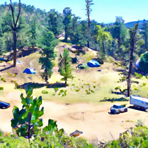
The campground features 32 campsites, each equipped with a table, fire ring, and grill. There are also restrooms and drinking water available on-site. Reservations are recommended as the campground can fill up quickly during peak season.
One interesting fact about the area is that it is home to the Pacific Crest Trail, a 2,650-mile long hiking trail that stretches from Mexico to Canada. The best time to visit Sweetwater Summit Camping Area is during the summer months, with average temperatures ranging from 70-80 degrees Fahrenheit.
Overall, Sweetwater Summit Camping Area is a great option for those looking to escape the hustle and bustle of city life and immerse themselves in the stunning natural beauty of the Sierra Nevada Mountains.
What's on-site at Sweetwater Summit
Key facilities Snoflo tracks for this campground. Confirm with the operator before booking -- amenities can change seasonally.
Plan your trip down to the hour
Same weather feed Snoflo's iOS app uses -- updated continuously from NOAA / yr.no.
Next 5 days, hour by hour
Temperature line with weather symbols on top, snow + rain accumulation as columns, humidity as a dotted line.
5-day forecast table
Every 3 hours, broken out across temperature, snow, rain, humidity, and wind. Each cell is colour-coded relative to the column min/max so trends jump out at a glance.
| Time | Condition | Temp (°F) | Snow (in) | Rain (in) | Humidity (%) | Wind (mps) | Wind dir |
|---|---|---|---|---|---|---|---|
| Loading detailed forecast… | |||||||
15-day temperature & precipitation
Daily temperatures, snow, and rain projected over the next two weeks. Hover any point for the full breakdown.
Other campgrounds in the area
Snoflo-tracked campsites within driving distance of Sweetwater Summit, with reservations status.
| Campground | Reservations | Toilets | View |
|---|---|---|---|
| Kumeyaay Lake Campground - Mission Trails Park | ✗ | ✓ | → |
| Silver Strand State Beach Dispersed | ✗ | ✗ | → |
| Tt Pio Pico Rv Resort | ✗ | ✗ | → |
| Fiddlers Cove Rv Military - Coronado Nb | ✓ | ✓ | → |
| Admiral Baker Military - San Diego Ns | ✓ | ✓ | → |
Nearby streamflow
USGS streamgauges within reach of Sweetwater Summit -- pulled live from the National Water Information System.
| Streamgauge | Discharge | View |
|---|---|---|
| Jamul C Nr Jamul Ca | 8 cfs | → |
| Sweetwater R A Dehesa Ca | · | → |
| San Diego R A Mast Rd Nr Santee Ca | 1 cfs | → |
| San Diego R A Fashion Valley At San Diego Ca | 2 cfs | → |
| Los Coches C Nr Lakeside Ca | 0 cfs | → |
| Los Penasquitos C Nr Poway Ca | 0 cfs | → |
Nearby snow depths
NRCS SNOTEL stations within reach of Sweetwater Summit -- relevant when planning a shoulder-season or alpine trip.
| SNOTEL station | Snowpack | 24h Snowfall | View |
|---|---|---|---|
| El Cajon 2.8 Sse | 0.0 in | 0.0 in | → |
| Escondido 0.5 Sse | 0.0 in | 0.0 in | → |
Plan a longer trip
The closest parks, lakes, boat launches, and paddle runs so a camping night can grow into a full weekend.
Parks
- Sweetwater County Park Summit
- Spring Valley County Park
- Mount San Miguel Park
- Bonita Long Canyon Park
- Bay Terrace Community Park
- Skyline Community Park
Boat launches
- Lower Otay Lake
- National City (Pepper Park)
- Marine Group Boat Works
- Bayfront Park - Chula Vista
- Murray Reservoir
- Glorietta Bay
Fishing spots
Camping essentials & Leave No Trace
- Pack it in, pack it out
- Take all trash, food scraps, and gear back with you to keep campsites clean and protect wildlife.
- Respect wildlife
- Observe animals from a distance, store food securely, and never feed wildlife to maintain natural behavior and safety.
- Know before you go
- Check weather, fire restrictions, trail conditions, and permit requirements to ensure a safe and well-planned trip.
- Minimize campfire impact
- Use established fire rings, keep fires small, fully extinguish them, or opt for a camp stove when fires are restricted.
- Leave what you find
- Preserve natural and cultural features by avoiding removal of plants, rocks, artifacts, or other elements of the environment.
Set push alerts in the Snoflo app
Save Sweetwater Summit as a favorite, set a custom threshold (precipitation, snowpack, freezing temperatures), and the iOS app will push the moment conditions cross.
About Sweetwater Summit
Can I make reservations at Sweetwater Summit?
Yes -- this campground accepts reservations. Snoflo recommends booking early for peak season; check the operator (Recreation.gov / state park system / private operator) for the booking window and cancellation policy.
How fresh is the weather data on this page?
The hourly forecast updates throughout the day from the NOAA / yr.no public feeds. Streamflow data is pulled live from USGS streamgauges and snowpack from the NRCS SNOTEL network.
What's the best time of year to visit?
Use the 15-day temperature & precipitation outlook on this page to plan -- pick a window with comfortable temperatures and low precipitation. For longer trips, the 5-day hourly meteogram shows snow + rain accumulation hour-by-hour.
How do I get to Sweetwater Summit?
Tap Directions in the hero above to open driving directions in Google Maps, or Open in map to center the Snoflo interactive map on the campground.
Can I get alerts when conditions change?
Yes -- alerts are managed through the Snoflo iOS app. Favorite this campground, set a threshold (temperature, snowpack, precipitation), and you'll get a push the moment it crosses.
Other campgrounds near here
Snoflo-tracked campgrounds within driving distance of Sweetwater Summit.