The Pinnacles campground
Community Reviews
Been here? Share the conditions.
Reviews, ratings & photos are added in the free Snoflo iOS app — rate a spot, tag the conditions, and your visit is verified by location. Add or manage your reviews from the app.
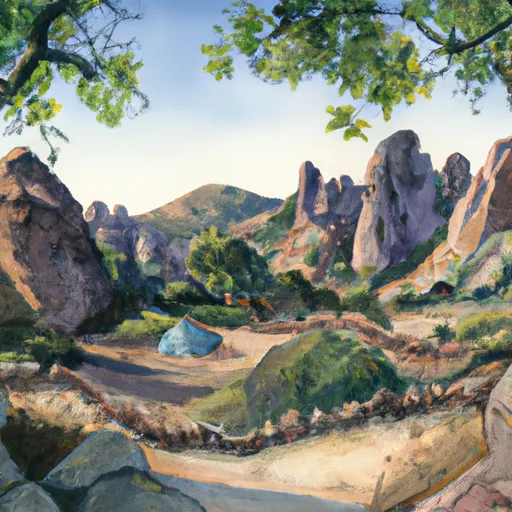
The Pinnacles
The campground offers a range of amenities, including water, restrooms, picnic tables, fire rings, and a visitor center. The campground is available on a first-come-first-serve basis, and it is recommended to arrive early to secure a spot. There are a total of 134 campsites available, with no electrical or water hookups.
One interesting fact about the park is that it is the result of a volcanic eruption that occurred millions of years ago, leaving behind unique rock formations that are a favorite among rock climbers. The best time to visit the park is during the spring and fall, with average temperatures ranging from the mid-60s to low 80s during the day and the mid-40s to 50s at night.
Some nearby points of interest include the Bear Gulch Cave Trail, the Balconies Trail, and the High Peaks Trail. Visitors can also explore the nearby San Andreas Fault or take a scenic drive through the park. Overall, the Pinnacles Camping Area is a must-visit destination for nature lovers and outdoor enthusiasts looking for a unique camping experience in California.
What's on-site at The Pinnacles
Key facilities Snoflo tracks for this campground. Confirm with the operator before booking -- amenities can change seasonally.
Plan your trip down to the hour
Same weather feed Snoflo's iOS app uses -- updated continuously from NOAA / yr.no.
Next 5 days, hour by hour
Temperature line with weather symbols on top, snow + rain accumulation as columns, humidity as a dotted line.
5-day forecast table
Every 3 hours, broken out across temperature, snow, rain, humidity, and wind. Each cell is colour-coded relative to the column min/max so trends jump out at a glance.
| Time | Condition | Temp (°F) | Snow (in) | Rain (in) | Humidity (%) | Wind (mps) | Wind dir |
|---|---|---|---|---|---|---|---|
| Loading detailed forecast… | |||||||
15-day temperature & precipitation
Daily temperatures, snow, and rain projected over the next two weeks. Hover any point for the full breakdown.
Other campgrounds in the area
Snoflo-tracked campsites within driving distance of The Pinnacles, with reservations status.
| Campground | Reservations | Toilets | View |
|---|---|---|---|
| Holcomb Valley Campground | ✓ | ✗ | → |
| Holcomb Valley | ✗ | ✓ | → |
| Tanglewood Group Campround | ✗ | ✗ | → |
| Tanglewood Group Campground | ✓ | ✗ | → |
| Yellow Post 31 | ✗ | ✗ | → |
Nearby streamflow
USGS streamgauges within reach of The Pinnacles -- pulled live from the National Water Information System.
| Streamgauge | Discharge | View |
|---|---|---|
| Sar Supp Gage Nr Mentone Ca | 23 cfs | → |
| Santa Ana R Nr Mentone (River Only) Ca | 37 cfs | → |
| Plunge C Nr East Highlands Ca | 2 cfs | → |
| Deep C Nr Hesperia Ca | 3 cfs | → |
| City C Nr Highland Ca | 0 cfs | → |
| Wf Mojave R Ab Mojave R Forks Res Nr Hesperia Ca | 1 cfs | → |
Nearby snow depths
NRCS SNOTEL stations within reach of The Pinnacles -- relevant when planning a shoulder-season or alpine trip.
| SNOTEL station | Snowpack | 24h Snowfall | View |
|---|---|---|---|
| Lake Arrowhead 1.5 Se | 0.0 in | 0.0 in | → |
| Johnson Valley | 0.0 in | 0.0 in | → |
| Hesperia 1ene | 0.0 in | 0.0 in | → |
| Barstow Fire Station | 0.0 in | 0.0 in | → |
Plan a longer trip
The closest parks, lakes, boat launches, and paddle runs so a camping night can grow into a full weekend.
Parks
Boat launches
- Carol Morrison (East)
- Pine Knot Landing
- Big Bear Marina
- Holloway's Marina, Inc.
- Duane Boyer (West)
- Pleasure Point Landing
Fishing spots
- Big Bear Lake
- Holcomb Creek
- Santa Ana River
- Santa Ana River - South Fork
- Green Valley Lake
- Arrowbear Lake
Points of interest
Camping essentials & Leave No Trace
- Pack it in, pack it out
- Take all trash, food scraps, and gear back with you to keep campsites clean and protect wildlife.
- Respect wildlife
- Observe animals from a distance, store food securely, and never feed wildlife to maintain natural behavior and safety.
- Know before you go
- Check weather, fire restrictions, trail conditions, and permit requirements to ensure a safe and well-planned trip.
- Minimize campfire impact
- Use established fire rings, keep fires small, fully extinguish them, or opt for a camp stove when fires are restricted.
- Leave what you find
- Preserve natural and cultural features by avoiding removal of plants, rocks, artifacts, or other elements of the environment.
Set push alerts in the Snoflo app
Save The Pinnacles as a favorite, set a custom threshold (precipitation, snowpack, freezing temperatures), and the iOS app will push the moment conditions cross.
About The Pinnacles
Can I make reservations at The Pinnacles?
This campground does not appear to accept reservations -- it's typically first-come, first-served. Arrive early on summer weekends.
How fresh is the weather data on this page?
The hourly forecast updates throughout the day from the NOAA / yr.no public feeds. Streamflow data is pulled live from USGS streamgauges and snowpack from the NRCS SNOTEL network.
What's the best time of year to visit?
Use the 15-day temperature & precipitation outlook on this page to plan -- pick a window with comfortable temperatures and low precipitation. For longer trips, the 5-day hourly meteogram shows snow + rain accumulation hour-by-hour.
How do I get to The Pinnacles?
Tap Directions in the hero above to open driving directions in Google Maps, or Open in map to center the Snoflo interactive map on the campground.
Can I get alerts when conditions change?
Yes -- alerts are managed through the Snoflo iOS app. Favorite this campground, set a threshold (temperature, snowpack, precipitation), and you'll get a push the moment it crosses.
Other campgrounds near here
Snoflo-tracked campgrounds within driving distance of The Pinnacles.