Tom Lucas Trailcamp Campground
Community Reviews
Been here? Share the conditions.
Reviews, ratings & photos are added in the free Snoflo iOS app — rate a spot, tag the conditions, and your visit is verified by location. Add or manage your reviews from the app.
Tom Lucas Trailcamp
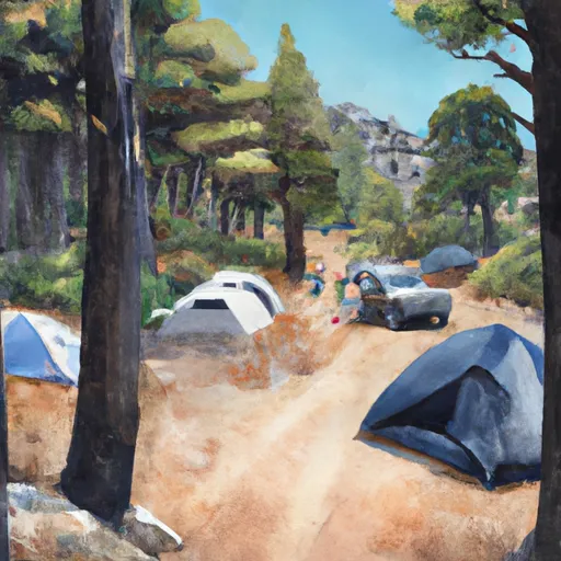
The campground features basic amenities such as vault toilets and fire rings, and campsites are first-come-first-served. There are a total of eight campsites available, suitable for tents, trailers, and RVs up to 25 feet in length. An interesting fact about the area is that it was once home to the largest gold mine in California, which operated from 1894 to 1942.
The best time of year to visit Tom Lucas Trailcamp is during the summer months when temperatures range from the mid-70s during the day to the mid-50s at night. However, hikers should be aware that thunderstorms are common during the summer months, so it's important to plan accordingly. In the winter, temperatures can drop below freezing, and snowfall is possible.
Overall, the Tom Lucas Trailcamp camping area is a great option for those looking for a secluded camping experience with beautiful views and nearby hiking trails.
What's on-site at Tom Lucas Trailcamp
Key facilities Snoflo tracks for this campground. Confirm with the operator before booking -- amenities can change seasonally.
Plan your trip down to the hour
Same weather feed Snoflo's iOS app uses -- updated continuously from NOAA / yr.no.
Next 5 days, hour by hour
Temperature line with weather symbols on top, snow + rain accumulation as columns, humidity as a dotted line.
5-day forecast table
Every 3 hours, broken out across temperature, snow, rain, humidity, and wind. Each cell is colour-coded relative to the column min/max so trends jump out at a glance.
| Time | Condition | Temp (°F) | Snow (in) | Rain (in) | Humidity (%) | Wind (mps) | Wind dir |
|---|---|---|---|---|---|---|---|
| Loading detailed forecast… | |||||||
15-day temperature & precipitation
Daily temperatures, snow, and rain projected over the next two weeks. Hover any point for the full breakdown.
Other campgrounds in the area
Snoflo-tracked campsites within driving distance of Tom Lucas Trailcamp, with reservations status.
| Campground | Reservations | Toilets | View |
|---|---|---|---|
| Lightning Point Group Campground | ✓ | ✗ | → |
| Messenger Flats | ✗ | ✓ | → |
| Messenger Flats Campground | ✗ | ✗ | → |
| Oakwilde Trail Camp (Not Maintained) | ✗ | ✗ | → |
| Oakwilde | ✗ | ✗ | → |
Nearby streamflow
USGS streamgauges within reach of Tom Lucas Trailcamp -- pulled live from the National Water Information System.
| Streamgauge | Discharge | View |
|---|---|---|
| Arroyo Seco Nr Pasadena Ca | 1 cfs | → |
| Big Tujunga C Bl Hansen Dam Ca | 8 cfs | → |
| Los Angeles R A Sepulveda Dam Ca | 40 cfs | → |
| Rio Hondo Ab Whittier Narrows Dam Ca | 1 cfs | → |
| San Gabriel R Bl Santa Fe Dam Nr Baldwin Pk Ca | · | → |
| Rio Hondo Bl Whittier Narrows Dam Ca | · | → |
Plan a longer trip
The closest parks, lakes, boat launches, and paddle runs so a camping night can grow into a full weekend.
Parks
- Oro Vista Park
- Little Landers Park
- Howard Finn Park
- Dunsmore Park
- Fehlhaber-Houk Park
- Mcgroarty Cultural Center Park
Boat launches
- Little Rock Reservoir
- Santa Fe Dam Recreation Area
- Lake Hughes Road Castaic
- Castaic Lake State Recreation Area (East)
- Csu Northridge Aquatic Center
Fishing spots
Points of interest
- Le Mesnager Barn
- Bolton Hall
- Camp 16
- Nike Missile Site La-98 (Closed)
- Tuna Canyon Detention Station
- Whites Art Framing & Restoration
Paddle runs
- West Fork - Headwaters (Se 1/4, Ne 1/4, Sec 14, T2n, R12w) To Cogswell Reservoir (Ne 1/4, Sw 1/4, Sec 24, T2n, R9w
- Mainstream - Confluence With South Fork Little Rock Creek To Little Rock Creek Reservoir
- Gaging Station Below Spillway Of Cogswell Dam (Ne 1/4, Se 1/4, Sec 19, T2n, R10w) To Confluence With Nf San Gabriel River (Sw 1/4.Sw 1/4, Sec 15, T2n, R9w)
- Cooper Canyon- Near State Highway 2 (Sw 1/4, Ne 1/4, Sec 16, T3n, R10w To Confluence With Little Rock Creek
- Mainstream - Confluence With Cooper Canyon To Confluence Wit South Fork Little Rock Creek
- Site Of St Francis Dam Disaster To Seco Canyon At The Nf Boundary
Camping essentials & Leave No Trace
- Pack it in, pack it out
- Take all trash, food scraps, and gear back with you to keep campsites clean and protect wildlife.
- Respect wildlife
- Observe animals from a distance, store food securely, and never feed wildlife to maintain natural behavior and safety.
- Know before you go
- Check weather, fire restrictions, trail conditions, and permit requirements to ensure a safe and well-planned trip.
- Minimize campfire impact
- Use established fire rings, keep fires small, fully extinguish them, or opt for a camp stove when fires are restricted.
- Leave what you find
- Preserve natural and cultural features by avoiding removal of plants, rocks, artifacts, or other elements of the environment.
Set push alerts in the Snoflo app
Save Tom Lucas Trailcamp as a favorite, set a custom threshold (precipitation, snowpack, freezing temperatures), and the iOS app will push the moment conditions cross.
About Tom Lucas Trailcamp
Can I make reservations at Tom Lucas Trailcamp?
This campground does not appear to accept reservations -- it's typically first-come, first-served. Arrive early on summer weekends.
How fresh is the weather data on this page?
The hourly forecast updates throughout the day from the NOAA / yr.no public feeds. Streamflow data is pulled live from USGS streamgauges and snowpack from the NRCS SNOTEL network.
What's the best time of year to visit?
Use the 15-day temperature & precipitation outlook on this page to plan -- pick a window with comfortable temperatures and low precipitation. For longer trips, the 5-day hourly meteogram shows snow + rain accumulation hour-by-hour.
How do I get to Tom Lucas Trailcamp?
Tap Directions in the hero above to open driving directions in Google Maps, or Open in map to center the Snoflo interactive map on the campground.
Can I get alerts when conditions change?
Yes -- alerts are managed through the Snoflo iOS app. Favorite this campground, set a threshold (temperature, snowpack, precipitation), and you'll get a push the moment it crosses.
Other campgrounds near here
Snoflo-tracked campgrounds within driving distance of Tom Lucas Trailcamp.