Yosemite Creek Campground
Community Reviews
Been here? Share the conditions.
Reviews, ratings & photos are added in the free Snoflo iOS app — rate a spot, tag the conditions, and your visit is verified by location. Add or manage your reviews from the app.
Yosemite Creek
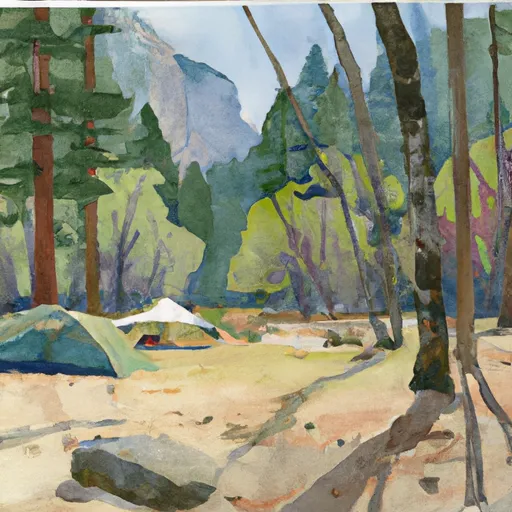
The Yosemite Creek Camping Area offers basic amenities such as picnic tables, fire pits, vault toilets, and bear-proof food storage lockers. The campground has 75 first-come-first-serve campsites, which means that reservations are not possible, and it can fill up quickly in the summer months.
An interesting fact about Yosemite Creek is that it was named after a group of Native Americans called the Ahwahneechee, who referred to the creek as "Cholock." The creek's name was changed to Yosemite Creek by early European settlers.
The best time of year to visit the Yosemite Creek Camping Area is during the summer months, from late May through early September. The average temperature during this time is around 70°F during the day and 40°F at night. Visitors should be prepared for cool evenings and potential thunderstorms during the summer months. Overall, Yosemite Creek Camping Area is a great spot for campers looking for a peaceful environment surrounded by stunning scenery.
What's on-site at Yosemite Creek
Key facilities Snoflo tracks for this campground. Confirm with the operator before booking -- amenities can change seasonally.
Plan your trip down to the hour
Same weather feed Snoflo's iOS app uses -- updated continuously from NOAA / yr.no.
Next 5 days, hour by hour
Temperature line with weather symbols on top, snow + rain accumulation as columns, humidity as a dotted line.
5-day forecast table
Every 3 hours, broken out across temperature, snow, rain, humidity, and wind. Each cell is colour-coded relative to the column min/max so trends jump out at a glance.
| Time | Condition | Temp (°F) | Snow (in) | Rain (in) | Humidity (%) | Wind (mps) | Wind dir |
|---|---|---|---|---|---|---|---|
| Loading detailed forecast… | |||||||
15-day temperature & precipitation
Daily temperatures, snow, and rain projected over the next two weeks. Hover any point for the full breakdown.
Other campgrounds in the area
Snoflo-tracked campsites within driving distance of Yosemite Creek, with reservations status.
| Campground | Reservations | Toilets | View |
|---|---|---|---|
| Yosemite Creek Campground | ✗ | ✗ | → |
| Yosemite Creek - Yosemite National Park | ✗ | ✓ | → |
| Porcupine Flat Campground | ✗ | ✗ | → |
| Porcupine Flat - Yosemite National Park | ✗ | ✓ | → |
| Porcupine Flat | ✗ | ✗ | → |
Nearby streamflow
USGS streamgauges within reach of Yosemite Creek -- pulled live from the National Water Information System.
| Streamgauge | Discharge | View |
|---|---|---|
| Merced R A Happy Isles Bridge Nr Yosemite Ca | 92 cfs | → |
| Tuolumne R A Grand Cyn Of Tuolumne Ab Hetch Hetchy | 128 cfs | → |
| Merced R A Pohono Bridge Nr Yosemite Ca | 119 cfs | → |
| Tuolumne R Nr Hetch Hetchy Ca | 111 cfs | → |
| Eleanor C Nr Hetch Hetchy Ca | 21 cfs | → |
| Lk Eleanor Div To Cherry Lake Nr Hetch Hetchy Ca | 1 cfs | → |
Nearby snow depths
NRCS SNOTEL stations within reach of Yosemite Creek -- relevant when planning a shoulder-season or alpine trip.
| SNOTEL station | Snowpack | 24h Snowfall | View |
|---|---|---|---|
| Nohrsc White Wolf Raws | 0.5 in | 0.0 in | → |
| Tenaya Lake | 0.2 in | 0.0 in | → |
| Nohrsc Tuolumne Meadows | 141.6 in | 0.0 in | → |
| Nohrsc Paradise Meadow | 0.0 in | 0.0 in | → |
| Nohrsc Tioga Pass-Dana Meadows | 30.4 in | 0.0 in | → |
| Nohrsc Lower Kibbie | 0.0 in | 0.0 in | → |
Plan a longer trip
The closest parks, lakes, boat launches, and paddle runs so a camping night can grow into a full weekend.
Parks
- Hoover Wilderness
- Stanislaus National Forest
- Wilderness Emigrant
- Yosemite National Park
- Mono Lake Tufa State Reserve
- Owens River Headwaters Wilderness
Fishing spots
Points of interest
- Indian Arch
- Upper Yosemite Fall
- Lower Yosemite Fall
- Indian Village Of The Ahwahnee
- Valley Visitor Center & Theater
- Yosemite Museum
Paddle runs
- Headwaters Near The Tuolumne And Mariposa County Lines To Western Boundary Of Yosemite National Park
- Headwaters Tributaries To Research Natural Area Boundary
- Saddlebag Lake Rna Boundary To State Highway 120
- Snow Lake To Hoover Wilderness Boundary
- Headwaters, Includes East Fork And West Fork To Hoover Wilderness Boundary
Camping essentials & Leave No Trace
- Pack it in, pack it out
- Take all trash, food scraps, and gear back with you to keep campsites clean and protect wildlife.
- Respect wildlife
- Observe animals from a distance, store food securely, and never feed wildlife to maintain natural behavior and safety.
- Know before you go
- Check weather, fire restrictions, trail conditions, and permit requirements to ensure a safe and well-planned trip.
- Minimize campfire impact
- Use established fire rings, keep fires small, fully extinguish them, or opt for a camp stove when fires are restricted.
- Leave what you find
- Preserve natural and cultural features by avoiding removal of plants, rocks, artifacts, or other elements of the environment.
Set push alerts in the Snoflo app
Save Yosemite Creek as a favorite, set a custom threshold (precipitation, snowpack, freezing temperatures), and the iOS app will push the moment conditions cross.
About Yosemite Creek
Can I make reservations at Yosemite Creek?
This campground does not appear to accept reservations -- it's typically first-come, first-served. Arrive early on summer weekends.
How fresh is the weather data on this page?
The hourly forecast updates throughout the day from the NOAA / yr.no public feeds. Streamflow data is pulled live from USGS streamgauges and snowpack from the NRCS SNOTEL network.
What's the best time of year to visit?
Use the 15-day temperature & precipitation outlook on this page to plan -- pick a window with comfortable temperatures and low precipitation. For longer trips, the 5-day hourly meteogram shows snow + rain accumulation hour-by-hour.
How do I get to Yosemite Creek?
Tap Directions in the hero above to open driving directions in Google Maps, or Open in map to center the Snoflo interactive map on the campground.
Can I get alerts when conditions change?
Yes -- alerts are managed through the Snoflo iOS app. Favorite this campground, set a threshold (temperature, snowpack, precipitation), and you'll get a push the moment it crosses.
Other campgrounds near here
Snoflo-tracked campgrounds within driving distance of Yosemite Creek.