Yuba Pass Campground
Community Reviews
Been here? Share the conditions.
Reviews, ratings & photos are added in the free Snoflo iOS app — rate a spot, tag the conditions, and your visit is verified by location. Add or manage your reviews from the app.
Yuba Pass
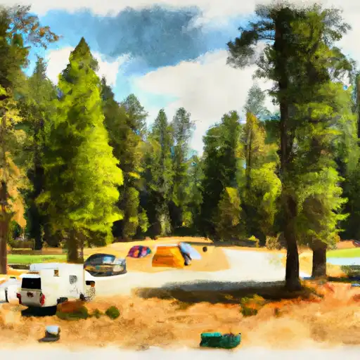
The campground has 24 first-come-first-serve campsites, each with a picnic table and fire ring. There are also vault toilets and potable water available for campers.
Nearby points of interest include the Lakes Basin Recreation Area, which offers numerous lakes and trails for fishing and hiking. The historic town of Downieville, with its Gold Rush history, is also a short drive away.
An interesting fact about the area is that it was once home to the Nisenan tribe, who hunted and fished in the surrounding mountains for thousands of years before the arrival of European settlers.
The best time of year to visit Yuba Pass Campground is during the summer months, with average temperatures ranging from 70-80 degrees Fahrenheit during the day and dropping to 40-50 degrees Fahrenheit at night. However, the area is also beautiful in the fall with the changing leaves of the aspen trees.
What's on-site at Yuba Pass
Key facilities Snoflo tracks for this campground. Confirm with the operator before booking -- amenities can change seasonally.
Plan your trip down to the hour
Same weather feed Snoflo's iOS app uses -- updated continuously from NOAA / yr.no.
Next 5 days, hour by hour
Temperature line with weather symbols on top, snow + rain accumulation as columns, humidity as a dotted line.
5-day forecast table
Every 3 hours, broken out across temperature, snow, rain, humidity, and wind. Each cell is colour-coded relative to the column min/max so trends jump out at a glance.
| Time | Condition | Temp (°F) | Snow (in) | Rain (in) | Humidity (%) | Wind (mps) | Wind dir |
|---|---|---|---|---|---|---|---|
| Loading detailed forecast… | |||||||
15-day temperature & precipitation
Daily temperatures, snow, and rain projected over the next two weeks. Hover any point for the full breakdown.
Other campgrounds in the area
Snoflo-tracked campsites within driving distance of Yuba Pass, with reservations status.
| Campground | Reservations | Toilets | View |
|---|---|---|---|
| Yuba Pass Campground | ✓ | ✗ | → |
| Chapman Creek | ✓ | ✓ | → |
| Chapman Creek Campground | ✓ | ✗ | → |
| Sierra | ✓ | ✓ | → |
| Sierra Campground | ✓ | ✗ | → |
Nearby streamflow
USGS streamgauges within reach of Yuba Pass -- pulled live from the National Water Information System.
| Streamgauge | Discharge | View |
|---|---|---|
| Little Truckee R Bl Div Dam Nr Sierraville Ca | 3 cfs | → |
| Independence C Nr Truckee Ca | 4 cfs | → |
| Sagehen C Nr Truckee Ca | 2 cfs | → |
| Donner C A Donner Lk Nr Truckee Ca | 4 cfs | → |
| N Yuba R Bl Goodyears Bar Ca | 154 cfs | → |
| Little Truckee R Ab Boca Res Nr Truckee Ca | 105 cfs | → |
Nearby snow depths
NRCS SNOTEL stations within reach of Yuba Pass -- relevant when planning a shoulder-season or alpine trip.
| SNOTEL station | Snowpack | 24h Snowfall | View |
|---|---|---|---|
| Nohrsc Meadow Lk Snow Course | 21.2 in | 0.2 in | → |
| Nohrsc Independence Creek | 0.0 in | 0.0 in | → |
| Independence Creek | 0.0 in | 0.0 in | → |
| Nohrsc Independence Camp | 0.0 in | 0.0 in | → |
| Independence Camp | 0.0 in | 0.0 in | → |
| Independence Lake | 0.0 in | 0.0 in | → |
Plan a longer trip
The closest parks, lakes, boat launches, and paddle runs so a camping night can grow into a full weekend.
Parks
- Flag Hill Park
- Bogart County Park
- Edgar Canyon Nature Park
- Yucaipa Regional Park
- Beaumont Sports Park
- Erwin Lake Park
Boat launches
- Big Bear Marina
- Pine Knot Landing
- Pleasure Point Landing
- Holloway's Marina, Inc.
- Carol Morrison (East)
- Duane Boyer (West)
Fishing spots
- Mill Creek
- Santa Ana River - South Fork
- Santa Ana River
- Yucaipa Park Lake
- Big Bear Lake
- Arrowbear Lake
Points of interest
- C-47 Crash Site
- Mountain Home Village Scenic Overlook
- Edward Dean Museum Of Decorative Arts
- Champion Lodgepole Pine
- Gilman Ranch
- Big Bear Snow Play
Paddle runs
- South Fork Meadows To San Gorgonia Wilderness Boundary
- South Fork Headwaters To San Gorgonio Wilderness Boundary/Sf Diversion Dam
- East Fork Headwaters To Confluence With South Fork
- Headwaters To San Gorgonio Wilderness
- Big Meadows To Filaree Flat
- Middle Fork Headwaters At Middle Fork Jumpoff To Confluence With North Fork
Camping essentials & Leave No Trace
- Pack it in, pack it out
- Take all trash, food scraps, and gear back with you to keep campsites clean and protect wildlife.
- Respect wildlife
- Observe animals from a distance, store food securely, and never feed wildlife to maintain natural behavior and safety.
- Know before you go
- Check weather, fire restrictions, trail conditions, and permit requirements to ensure a safe and well-planned trip.
- Minimize campfire impact
- Use established fire rings, keep fires small, fully extinguish them, or opt for a camp stove when fires are restricted.
- Leave what you find
- Preserve natural and cultural features by avoiding removal of plants, rocks, artifacts, or other elements of the environment.
Set push alerts in the Snoflo app
Save Yuba Pass as a favorite, set a custom threshold (precipitation, snowpack, freezing temperatures), and the iOS app will push the moment conditions cross.
About Yuba Pass
Can I make reservations at Yuba Pass?
Yes -- this campground accepts reservations. Snoflo recommends booking early for peak season; check the operator (Recreation.gov / state park system / private operator) for the booking window and cancellation policy.
How fresh is the weather data on this page?
The hourly forecast updates throughout the day from the NOAA / yr.no public feeds. Streamflow data is pulled live from USGS streamgauges and snowpack from the NRCS SNOTEL network.
What's the best time of year to visit?
Use the 15-day temperature & precipitation outlook on this page to plan -- pick a window with comfortable temperatures and low precipitation. For longer trips, the 5-day hourly meteogram shows snow + rain accumulation hour-by-hour.
How do I get to Yuba Pass?
Tap Directions in the hero above to open driving directions in Google Maps, or Open in map to center the Snoflo interactive map on the campground.
Can I get alerts when conditions change?
Yes -- alerts are managed through the Snoflo iOS app. Favorite this campground, set a threshold (temperature, snowpack, precipitation), and you'll get a push the moment it crosses.
Other campgrounds near here
Snoflo-tracked campgrounds within driving distance of Yuba Pass.