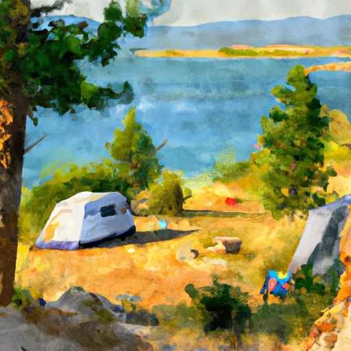
Arapaho Bay campground
Community Reviews
Been here? Share the conditions.
Reviews, ratings & photos are added in the free Snoflo iOS app — rate a spot, tag the conditions, and your visit is verified by location. Add or manage your reviews from the app.
Arapaho Bay
Campsite reservations are available and highly recommended for Arapaho Bay Camping Area. It is advised to make reservations well in advance, especially during peak seasons, as the campground tends to fill up quickly. Reservations can be made through the official Rocky Mountain National Park website or by calling the park office.
The best time to visit Arapaho Bay Camping Area is during the summer months, from June to September. This is when the weather is most favorable for camping, with mild temperatures and less chance of rainfall. Visitors can enjoy various outdoor activities such as hiking, fishing, boating, and wildlife viewing during this time.
While exploring the camping area, campers should be cautious of the local wildlife, especially bears. It is crucial to follow all bear safety guidelines, such as storing food properly and using bear-resistant containers. Additionally, campers should remember to practice Leave No Trace principles, respecting the natural environment and keeping the campground clean and pristine.
Overall, Arapaho Bay Camping Area offers a delightful camping experience with its beautiful surroundings and convenient amenities. By making reservations in advance, campers can ensure a spot at this popular destination and enjoy a memorable outdoor adventure in the heart of Colorado.
What's on-site at Arapaho Bay
Key facilities Snoflo tracks for this campground. Confirm with the operator before booking -- amenities can change seasonally.
Plan your trip down to the hour
Same weather feed Snoflo's iOS app uses -- updated continuously from NOAA / yr.no.
Next 5 days, hour by hour
Temperature line with weather symbols on top, snow + rain accumulation as columns, humidity as a dotted line.
5-day forecast table
Every 3 hours, broken out across temperature, snow, rain, humidity, and wind. Each cell is colour-coded relative to the column min/max so trends jump out at a glance.
| Time | Condition | Temp (°F) | Snow (in) | Rain (in) | Humidity (%) | Wind (mps) | Wind dir |
|---|---|---|---|---|---|---|---|
| Loading detailed forecast… | |||||||
15-day temperature & precipitation
Daily temperatures, snow, and rain projected over the next two weeks. Hover any point for the full breakdown.
Other campgrounds in the area
Snoflo-tracked campsites within driving distance of Arapaho Bay, with reservations status.
| Campground | Reservations | Toilets | View |
|---|---|---|---|
| Arapaho Bay Campground | ✓ | ✗ | → |
| 1972 Rainbow Gathering Site | ✗ | ✗ | → |
| Sunset Point | ✗ | ✓ | → |
| Green Ridge Campground | ✓ | ✗ | → |
| Green Ridge | ✓ | ✓ | → |
Nearby streamflow
USGS streamgauges within reach of Arapaho Bay -- pulled live from the National Water Information System.
| Streamgauge | Discharge | View |
|---|---|---|
| Colorado River Below Lake Granby | 82 cfs | → |
| Colorado River Bl Shadow Mountain Reservoir | 51 cfs | → |
| Colorado River Near Granby | 78 cfs | → |
| Ranch Creek Blw Meadow Cr Nr Tabernash Co | 7 cfs | → |
| Fraser River Blw Crooked Cr At Tabernash Co | 22 cfs | → |
| Cabin Creek Near Fraser | 1 cfs | → |
Nearby snow depths
NRCS SNOTEL stations within reach of Arapaho Bay -- relevant when planning a shoulder-season or alpine trip.
| SNOTEL station | Snowpack | 24h Snowfall | View |
|---|---|---|---|
| High Lonesome | 0.0 in | -1.0 in | → |
| High Lonesome | 0.0 in | 0.0 in | → |
| Nohrsc Sawtooth | 1.0 in | 0.0 in | → |
| Sawtooth | 1.0 in | 0.0 in | → |
| Nohrsc Wild Basin | 0.0 in | 0.0 in | → |
| Tabernash 2.7 Nw | 1.0 in | 1.3 in | → |
Plan a longer trip
The closest parks, lakes, boat launches, and paddle runs so a camping night can grow into a full weekend.
Parks
- Rocky Mountain National Park
- Wilderness Indian Peaks
- Protection Area (National) Bowen Gulch Protection Area (National)
- Wilderness Never Summer
- Protection Area (National) James Peak Protection Area (National)
- Wilderness James Peak
Boat launches
- Cr 6 Grand County
- Grand County
- Us 34 Grand County
- Boat Launch Grand Lake
- Hilltop Boating Site
- Willow Creek Boating Site
Fishing spots
- Monarch Lake
- Long Lake (Hell Canyon) - Ipwa
- Crawford Lake (Hell Canyon) - Ipwa
- Watanga Lake - Ipwa
- Round Lake - Ipwa
- Meadow Creek Reservoir
Points of interest
- Osprey Viewing Site
- Grand County Bird List
- Pawnee Overlook Observation Site
- Kawuneeche Visitor Center
- Redemption Dog Sled Tours
- Archery Range
Paddle runs
- Headwaters To Ends 0.5 Miles Away From Trail Ridge Road
- Headwaters To Ends 0.5 Miles Upstream From End Of County Hwy 115
- Begins 0.5 Miles Upstream From End Of County Hwy 115 To Eastern Boundary Of Rocky Mountain National Park
- Nsv
- Begins 0.5 Miles Upstream From End Of Fern Lake Road To Eastern Boundary Of Rocky Mountain National Park
- Ssv - Confluence To Picnic Grounds
Camping essentials & Leave No Trace
- Pack it in, pack it out
- Take all trash, food scraps, and gear back with you to keep campsites clean and protect wildlife.
- Respect wildlife
- Observe animals from a distance, store food securely, and never feed wildlife to maintain natural behavior and safety.
- Know before you go
- Check weather, fire restrictions, trail conditions, and permit requirements to ensure a safe and well-planned trip.
- Minimize campfire impact
- Use established fire rings, keep fires small, fully extinguish them, or opt for a camp stove when fires are restricted.
- Leave what you find
- Preserve natural and cultural features by avoiding removal of plants, rocks, artifacts, or other elements of the environment.
Set push alerts in the Snoflo app
Save Arapaho Bay as a favorite, set a custom threshold (precipitation, snowpack, freezing temperatures), and the iOS app will push the moment conditions cross.
About Arapaho Bay
Can I make reservations at Arapaho Bay?
Yes -- this campground accepts reservations. Snoflo recommends booking early for peak season; check the operator (Recreation.gov / state park system / private operator) for the booking window and cancellation policy.
How fresh is the weather data on this page?
The hourly forecast updates throughout the day from the NOAA / yr.no public feeds. Streamflow data is pulled live from USGS streamgauges and snowpack from the NRCS SNOTEL network.
What's the best time of year to visit?
Use the 15-day temperature & precipitation outlook on this page to plan -- pick a window with comfortable temperatures and low precipitation. For longer trips, the 5-day hourly meteogram shows snow + rain accumulation hour-by-hour.
How do I get to Arapaho Bay?
Tap Directions in the hero above to open driving directions in Google Maps, or Open in map to center the Snoflo interactive map on the campground.
Can I get alerts when conditions change?
Yes -- alerts are managed through the Snoflo iOS app. Favorite this campground, set a threshold (temperature, snowpack, precipitation), and you'll get a push the moment it crosses.
Other campgrounds near here
Snoflo-tracked campgrounds within driving distance of Arapaho Bay.