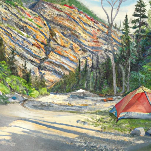
Avalanche Creek Campground
Community Reviews
Been here? Share the conditions.
Reviews, ratings & photos are added in the free Snoflo iOS app — rate a spot, tag the conditions, and your visit is verified by location. Add or manage your reviews from the app.
Avalanche Creek
Reservations are not accepted at Avalanche Creek camping area, making it a first-come, first-served campground. Therefore, it is advisable to arrive early, especially during peak season, to secure a camping spot. The best time to visit this campground is during the summer months when the weather is pleasant, ranging from June to September. During this time, campers can enjoy activities such as hiking, fishing, and wildlife viewing in the nearby Glacier National Park.
While exploring Avalanche Creek camping area, campers must be cautious of potential wildlife encounters, particularly bears. It is crucial to properly store food and dispose of trash to prevent attracting these animals. Additionally, visitors should be aware of their surroundings and follow guidelines for safe camping and hiking practices. By respecting the natural environment and taking necessary precautions, campers can have a memorable and enjoyable experience at Avalanche Creek camping area in Montana.
What's on-site at Avalanche Creek
Key facilities Snoflo tracks for this campground. Confirm with the operator before booking -- amenities can change seasonally.
Plan your trip down to the hour
Same weather feed Snoflo's iOS app uses -- updated continuously from NOAA / yr.no.
Next 5 days, hour by hour
Temperature line with weather symbols on top, snow + rain accumulation as columns, humidity as a dotted line.
5-day forecast table
Every 3 hours, broken out across temperature, snow, rain, humidity, and wind. Each cell is colour-coded relative to the column min/max so trends jump out at a glance.
| Time | Condition | Temp (°F) | Snow (in) | Rain (in) | Humidity (%) | Wind (mps) | Wind dir |
|---|---|---|---|---|---|---|---|
| Loading detailed forecast… | |||||||
15-day temperature & precipitation
Daily temperatures, snow, and rain projected over the next two weeks. Hover any point for the full breakdown.
Other campgrounds in the area
Snoflo-tracked campsites within driving distance of Avalanche Creek, with reservations status.
| Campground | Reservations | Toilets | View |
|---|---|---|---|
| Avalanche Creek - Glacier National Park | ✗ | ✗ | → |
| Snyder Lake | ✗ | ✗ | → |
| Arrow Lake | ✗ | ✗ | → |
| Camas Lake | ✗ | ✗ | → |
| Sperry | ✗ | ✗ | → |
Nearby streamflow
USGS streamgauges within reach of Avalanche Creek -- pulled live from the National Water Information System.
| Streamgauge | Discharge | View |
|---|---|---|
| Swiftcurrent Cr Ab Swiftcurrent Lk At Many Glacier | 113 cfs | → |
| Swiftcurrent Creek At Many Glacier Mt | 121 cfs | → |
| Middle Fork Flathead River Nr West Glacier Mt | 1,990 cfs | → |
| N F Flathead River Nr Columbia Falls Mt | 1,950 cfs | → |
| St. Mary River Near Babb Mt | 1,220 cfs | → |
| St. Mary Canal At Intake Near Babb Mt | 54 cfs | → |
Nearby snow depths
NRCS SNOTEL stations within reach of Avalanche Creek -- relevant when planning a shoulder-season or alpine trip.
| SNOTEL station | Snowpack | 24h Snowfall | View |
|---|---|---|---|
| Nohrsc Flattop Mtn. | 0.0 in | 0.0 in | → |
| Flattop Mtn. | 0.0 in | 0.0 in | → |
| Nohrsc Many Glacier | 0.0 in | 0.0 in | → |
| Many Glacier | 0.0 in | 0.0 in | → |
| West Glacier | 0.0 in | 0.0 in | → |
| Emery Creek | 0.0 in | 0.0 in | → |
Plan a longer trip
The closest parks, lakes, boat launches, and paddle runs so a camping night can grow into a full weekend.
Parks
- Waterton Lakes National Park Of Canada
- Les Mason State Park
- Depot Park Whitefish
- Whitefish Lake State Park
- Glacier National Park
Boat launches
- Apgar
- Rising Sun
- Flathead County
- Apgar Flats Horse West Glacier
- Big Creek River Access Boating Site
- Paul's Memorial
Fishing spots
Camping essentials & Leave No Trace
- Pack it in, pack it out
- Take all trash, food scraps, and gear back with you to keep campsites clean and protect wildlife.
- Respect wildlife
- Observe animals from a distance, store food securely, and never feed wildlife to maintain natural behavior and safety.
- Know before you go
- Check weather, fire restrictions, trail conditions, and permit requirements to ensure a safe and well-planned trip.
- Minimize campfire impact
- Use established fire rings, keep fires small, fully extinguish them, or opt for a camp stove when fires are restricted.
- Leave what you find
- Preserve natural and cultural features by avoiding removal of plants, rocks, artifacts, or other elements of the environment.
Set push alerts in the Snoflo app
Save Avalanche Creek as a favorite, set a custom threshold (precipitation, snowpack, freezing temperatures), and the iOS app will push the moment conditions cross.
About Avalanche Creek
Can I make reservations at Avalanche Creek?
This campground does not appear to accept reservations -- it's typically first-come, first-served. Arrive early on summer weekends.
How fresh is the weather data on this page?
The hourly forecast updates throughout the day from the NOAA / yr.no public feeds. Streamflow data is pulled live from USGS streamgauges and snowpack from the NRCS SNOTEL network.
What's the best time of year to visit?
Use the 15-day temperature & precipitation outlook on this page to plan -- pick a window with comfortable temperatures and low precipitation. For longer trips, the 5-day hourly meteogram shows snow + rain accumulation hour-by-hour.
How do I get to Avalanche Creek?
Tap Directions in the hero above to open driving directions in Google Maps, or Open in map to center the Snoflo interactive map on the campground.
Can I get alerts when conditions change?
Yes -- alerts are managed through the Snoflo iOS app. Favorite this campground, set a threshold (temperature, snowpack, precipitation), and you'll get a push the moment it crosses.
Other campgrounds near here
Snoflo-tracked campgrounds within driving distance of Avalanche Creek.