Devils Garden - Arches National Park Campground
Community Reviews
Been here? Share the conditions.
Reviews, ratings & photos are added in the free Snoflo iOS app — rate a spot, tag the conditions, and your visit is verified by location. Add or manage your reviews from the app.
Devils Garden - Arches National Park
Reservations are highly recommended at Devils Garden Campground, as it tends to fill up quickly, especially during the peak season. Visitors can make reservations up to six months in advance, ensuring a spot at this popular camping destination. It is crucial to plan ahead and secure a reservation to avoid disappointment.
The best time to visit Devils Garden Campground is during the spring and fall, as the summer months can get extremely hot, with temperatures often exceeding 100°F (38°C). Additionally, the campground is closed during the winter season. During the peak season, it is advisable to arrive early to secure a good campsite and beat the crowds.
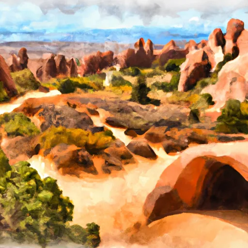
While camping at Devils Garden, visitors can explore a myriad of stunning natural attractions, including the iconic Delicate Arch, Landscape Arch, and many other unique rock formations. Hiking trails of varying difficulties are available, offering breathtaking views of the park's natural wonders. However, it is essential for campers to be cautious of the desert environment, as it can be unforgiving. They should bring plenty of water, wear appropriate clothing, and be wary of flash floods during storms. Additionally, respecting the park's regulations and practicing Leave No Trace principles is crucial to preserve the beauty of Devils Garden for future generations.
In conclusion, Devils Garden Campground in Arches National Park provides a memorable camping experience surrounded by breathtaking natural wonders. Campers should make reservations in advance, bring their own drinking water, and visit during the spring or fall for the best weather conditions. By taking precautions and respecting the environment, campers can fully enjoy the unique beauty and tranquility that Devils Garden has to offer.
What's on-site at Devils Garden - Arches National Park
Key facilities Snoflo tracks for this campground. Confirm with the operator before booking -- amenities can change seasonally.
Plan your trip down to the hour
Same weather feed Snoflo's iOS app uses -- updated continuously from NOAA / yr.no.
Next 5 days, hour by hour
Temperature line with weather symbols on top, snow + rain accumulation as columns, humidity as a dotted line.
5-day forecast table
Every 3 hours, broken out across temperature, snow, rain, humidity, and wind. Each cell is colour-coded relative to the column min/max so trends jump out at a glance.
| Time | Condition | Temp (°F) | Snow (in) | Rain (in) | Humidity (%) | Wind (mps) | Wind dir |
|---|---|---|---|---|---|---|---|
| Loading detailed forecast… | |||||||
15-day temperature & precipitation
Daily temperatures, snow, and rain projected over the next two weeks. Hover any point for the full breakdown.
Other campgrounds in the area
Snoflo-tracked campsites within driving distance of Devils Garden - Arches National Park, with reservations status.
| Campground | Reservations | Toilets | View |
|---|---|---|---|
| Devils Garden Campground | ✗ | ✗ | → |
| Willow Springs Trail Dispersed | ✗ | ✗ | → |
| Designated Campsite | ✗ | ✗ | → |
Nearby streamflow
USGS streamgauges within reach of Devils Garden - Arches National Park -- pulled live from the National Water Information System.
| Streamgauge | Discharge | View |
|---|---|---|
| Castle Creek Below Castle Valley Near Moab | 4 cfs | → |
| Mill Creek Blw Pack Creek Nr Mouth At Moab | 1 cfs | → |
| Colorado River Near Cisco | 1,610 cfs | → |
| Colorado River At Potash | 1,630 cfs | → |
| Dolores River Near Cisco | 32 cfs | → |
| Mill Creek Below Sheley Tunnel | 3 cfs | → |
Nearby snow depths
NRCS SNOTEL stations within reach of Devils Garden - Arches National Park -- relevant when planning a shoulder-season or alpine trip.
| SNOTEL station | Snowpack | 24h Snowfall | View |
|---|---|---|---|
| Arches Np Hqs Coop | 0.0 in | 0.0 in | → |
| Castle Valley 1se | 0.0 in | 0.0 in | → |
| Lasal Mountain-Lower | 0.0 in | 0.0 in | → |
| Lasal Mountain-Lower | 0.0 in | 0.0 in | → |
| Lasal Mountain | 1.0 in | 0.0 in | → |
| Lasal Mountain | 0.0 in | -1.0 in | → |
Plan a longer trip
The closest parks, lakes, boat launches, and paddle runs so a camping night can grow into a full weekend.
Parks
- Arches National Park
- Swanny City Park
- Sand Flats Recreation Area
- Old City Park
- Dead Horse Point State Park
- Mcinnis Canyons National Conservation Area
Boat launches
Fishing spots
Camping essentials & Leave No Trace
- Pack it in, pack it out
- Take all trash, food scraps, and gear back with you to keep campsites clean and protect wildlife.
- Respect wildlife
- Observe animals from a distance, store food securely, and never feed wildlife to maintain natural behavior and safety.
- Know before you go
- Check weather, fire restrictions, trail conditions, and permit requirements to ensure a safe and well-planned trip.
- Minimize campfire impact
- Use established fire rings, keep fires small, fully extinguish them, or opt for a camp stove when fires are restricted.
- Leave what you find
- Preserve natural and cultural features by avoiding removal of plants, rocks, artifacts, or other elements of the environment.
Set push alerts in the Snoflo app
Save Devils Garden - Arches National Park as a favorite, set a custom threshold (precipitation, snowpack, freezing temperatures), and the iOS app will push the moment conditions cross.
About Devils Garden - Arches National Park
Can I make reservations at Devils Garden - Arches National Park?
Yes -- this campground accepts reservations. Snoflo recommends booking early for peak season; check the operator (Recreation.gov / state park system / private operator) for the booking window and cancellation policy.
How fresh is the weather data on this page?
The hourly forecast updates throughout the day from the NOAA / yr.no public feeds. Streamflow data is pulled live from USGS streamgauges and snowpack from the NRCS SNOTEL network.
What's the best time of year to visit?
Use the 15-day temperature & precipitation outlook on this page to plan -- pick a window with comfortable temperatures and low precipitation. For longer trips, the 5-day hourly meteogram shows snow + rain accumulation hour-by-hour.
How do I get to Devils Garden - Arches National Park?
Tap Directions in the hero above to open driving directions in Google Maps, or Open in map to center the Snoflo interactive map on the campground.
Can I get alerts when conditions change?
Yes -- alerts are managed through the Snoflo iOS app. Favorite this campground, set a threshold (temperature, snowpack, precipitation), and you'll get a push the moment it crosses.
Other campgrounds near here
Snoflo-tracked campgrounds within driving distance of Devils Garden - Arches National Park.