

-
 Snoflo Premium
Get unlimited access to all our content
With no Ad interruptions! - Start Your Free Trial Login with existing account
Lake-Arrowhead
Eden Index
Climate
9.9
•
Recreation
9.4
•
Community
3.6
•
Safeguard
8.1/10
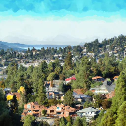
Lake Arrowhead is a charming mountain community nestled in the San Bernardino National Forest of Southern California. Known for its stunning alpine beauty, the town experiences a Mediterranean climate with mild, wet winters and warm, dry summers. Average temperatures range from the mid-30s°F in winter to the mid-70s°F in summer, making it an ideal year-round destination.
The main attraction of Lake Arrowhead is its namesake lake, a man-made reservoir fed by several creeks. The hydrology constituents of the lake include the waters of Little Bear Creek, Willow Creek, and Hook Creek. These tributaries contribute to the lake's refreshing, crystal-clear water. The lake offers various water activities, including boating, fishing, and swimming, with fishing enthusiasts particularly drawn to its abundant trout population.
In addition to water activities, Lake Arrowhead boasts numerous outdoor recreation opportunities. The surrounding forest provides ample hiking and biking trails, ideal for nature enthusiasts. The area also features several campgrounds, picnic areas, and wildlife viewing spots. For winter sports enthusiasts, nearby ski resorts offer opportunities for skiing, snowboarding, and snowshoeing. Overall, Lake Arrowhead offers a picturesque setting for outdoor lovers seeking a serene mountain getaway.
What is the Eden Index?
The Snoflo Eden Index serves as a comprehensive rating system for regions, evaluating their desirability through a holistic assessment of climate health, outdoor recreation opportunities, and natural disaster risk, acknowledging the profound impact of these factors on livability and well-being.
Climate Health Indicator (CHI): 9.9
Lake-Arrowhead receives approximately
724mm of rain per year,
with humidity levels near 72%
and air temperatures averaging around
12°C.
Lake-Arrowhead has a plant hardyness factor of
8, meaning
plants and agriculture in this region tend to thrive here all year round.
By considering the ideal temperature range, reliable water supplies, clean air, and stable seasonal rain or snowpacks, the Climate Health Indicator (CHI) underscores the significance of a healthy climate as the foundation for quality living.
A healthy climate is paramount for ensuring a high quality of life and livability in a region, fostering both physical well-being and environmental harmony. This can be characterized by ideal temperatures, reliable access to water supplies, clean air, and consistent seasonal rain or snowpacks.
Weather Forecast
Streamflow Conditions
Northern Mojave
Area Rivers
Northern Mojave
Snowpack Depths
Northern Mojave
Reservoir Storage Capacity
Northern Mojave
Groundwater Levels
Recreational Opportunity Index (ROI): 9.4
The Recreational Opportunity Index (ROI) recognizes the value of outdoor recreational options, such as parks, hiking trails, camping sites, and fishing spots, while acknowledging that climate plays a pivotal role in ensuring the comfort and consistency of these experiences.
Access to outdoor recreational opportunities, encompassing activities such as parks, hiking, camping, and fishing, is crucial for overall well-being, and the climate plays a pivotal role in enabling and enhancing these experiences, ensuring that individuals can engage in nature-based activities comfortably and consistently.
Camping Areas
| Campground | Campsites | Reservations | Toilets | Showers | Elevation |
|---|---|---|---|---|---|
| Crab Flats | 29 | 5,949 ft | |||
| Glen Helen Regional Park | 47 | 1,993 ft | |||
| Green Valley | 36 | 7,075 ft | |||
| March ARB Military | None | 1,509 ft | |||
| Mojave River Forks Regional Park | 65 | 3,163 ft | |||
| Lake Perris State Rec Area | 351 | 1,600 ft | |||
| Big Pine Flat | 20 | 6,837 ft | |||
| Silverwood Lake State Rec Area | 131 | 3,373 ft | |||
| Dogwood | 93 | 5,739 ft | |||
| Yucaipa Regional Park | 51 | 2,658 ft |
Catastrophe Safeguard Index (CSI):
The Catastrophe Safeguard Index (CSI) recognizes that natural disaster risk, encompassing floods, fires, hurricanes, and tornadoes, can drastically affect safety and the overall appeal of an area.
The level of natural disaster risk in a region significantly affects safety and the overall livability, with climate change amplifying these risks by potentially increasing the frequency and intensity of events like floods, fires, hurricanes, and tornadoes, thereby posing substantial challenges to community resilience and well-being.
Community Resilience Indicator (CRI): 3.6
The Community Resilience Indicator (CRI) recognizes that education, healthcare, and socioeconomics are crucial to the well-being of a region. The CRI acknowledges the profound impact of these elements on residents' overall quality of life. By evaluating educational resources, healthcare accessibility, and economic inclusivity, the index captures the essential aspects that contribute to a thriving community, fostering resident satisfaction, equity, and social cohesion.