Confluence With North Fork And Middle Fork Stanislaus To Clark Flat river run
Community Reviews
Been here? Share the conditions.
Reviews, ratings & photos are added in the free Snoflo iOS app — rate a spot, tag the conditions, and your visit is verified by location. Add or manage your reviews from the app.
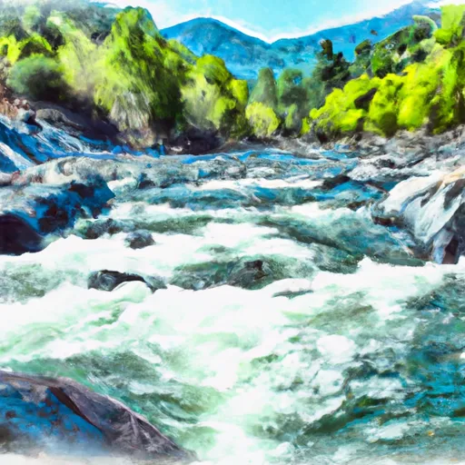
Confluence With North Fork And Middle Fork Stanislaus To Clark Flat
The specific rapids and obstacles that paddlers will encounter on this run include Clavey Falls, which is a steep 20-foot drop that requires precise boat control to navigate, and Ramshorn Falls, which is a narrow chute with a difficult entry. Paddlers must also be aware of numerous boulder gardens and strainers throughout the run.
The Confluence With North Fork And Middle Fork Stanislaus To Clark Flat run is within the jurisdiction of the Stanislaus National Forest, and therefore, specific regulations apply. The Forest Service requires all paddlers to have a personal flotation device and a helmet. Paddlers must also obtain a permit before accessing the river. Additionally, the Forest Service may close the river during periods of high water or fire danger.
Plan your run down to the hour
Same weather feed Snoflo's iOS app uses -- updated continuously from NOAA / yr.no. Watch the precipitation column on the meteogram; rain ahead of a run typically lifts flows 12-48 hours later depending on the basin.
Next 5 days, hour by hour
Temperature line with weather symbols on top, snow + rain accumulation as columns, humidity as a dotted line.
5-day forecast table
Every 3 hours, broken out across temperature, snow, rain, humidity, and wind. Each cell is colour-coded relative to the column min/max.
| Time | Condition | Temp (°F) | Snow (in) | Rain (in) | Humidity (%) | Wind (mps) | Wind dir |
|---|---|---|---|---|---|---|---|
| Loading detailed forecast… | |||||||
15-day temperature & precipitation
Daily temperatures, snow, and rain projected over the next two weeks -- the upstream story that drives next week's flows.
Regional streamflow levels
USGS streamgauges around Confluence With North Fork And Middle Fork Stanislaus To Clark Flat -- useful for spotting upstream pulses and gauging which tributary is contributing what.
| Streamgauge | Discharge | View |
|---|---|---|
| Black C Nr Copperopolis Ca | · | → |
| Big C Ab Whites Gulch Nr Groveland Ca | · | → |
| Cherry C Bl Valley Dam Nr Hetch Hetchy Ca | 16 cfs | → |
| Cherry C Bl Dion R Holm Ph | 98 cfs | → |
| Cherry C Nr Early Intake Ca | 39 cfs | → |
| Tuolumne R Bl Early Intake Nr Mather Ca | 136 cfs | → |
Plan a longer trip
The closest boat launches, other paddle runs, and campgrounds so a day on the water can grow into a full weekend.
Boat launches
- New Melones Lake (Angels Creek)
- New Melones Lake Marina
- New Melones Lake (Tuttletown)
- Glory Hole Road 6503, Angels Camp
- Beardsley Reservoir
Other river runs
- Sandbar To Confluence With North Fork Stanislaus River
- Below Mckay's Reservoir To Confluence With Middle Fork Stanislaus River
- One Mile Downstream Of State Park Boundary In Sec 24, T5n, R15e To Mckay's Reservoir
- Calaveras Big Trees State Park Boundary In Sec 24, T5n, R15e To One Mile Downstream Of State Park Boundary In Sec 24, T5n, R15e
- One-Quarter Mile Downstream Of Forest Road 5n75 Bridge Crossing To Calaveras Big Trees State Park Boundary In Sec 24, T5n, R15e
Campgrounds
- Columbia Airport Campground
- Calaveras Big Trees State Park
- Frogtown Rv Park
- Stanislaus View
- Lone Snag
- Sand Bar Flat Campground
Fishing spots
Whitewater safety
- Check the flow before you run
- Use the linked-gauge card and Regional Flow panel above. Class ratings change with flow -- a Class III at low water can become Class IV+ at high water.
- Know your skill ceiling
- Pick runs comfortably below your ceiling. Cold-water and big-water runs raise the consequences of any mistake.
- Wear the right gear
- Helmet, PFD, drysuit / wetsuit when water is below 60°F. Throw bag, knife, and whistle on your person, not in the boat.
- Scout, set safety, and run with a team
- Scout new rapids on foot, set safety with throw bags above the consequence pool, and run with at least one other competent paddler.
- Respect the river
- Strainers, undercuts, low-head dams, and wood can kill at any class rating. When in doubt, portage.
Set push alerts in the Snoflo app
Save Confluence With North Fork And Middle Fork Stanislaus To Clark Flat as a favorite, set a discharge threshold (e.g. "alert me when flow hits 600 cfs"), and the iOS app pushes the moment the linked gauge crosses.
About Confluence With North Fork And Middle Fork Stanislaus To Clark Flat
What's the optimal flow for Confluence With North Fork And Middle Fork Stanislaus To Clark Flat?
The optimal flow depends on the section and the craft. Check the Run Details panel for the linked gauge and current status.
How fresh is the cfs reading on this page?
The linked USGS streamgauge reports continuously (every 15 minutes); Snoflo refreshes throughout the day. Hover the streamflow sparkline to read individual datapoints.
What's the whitewater class?
See the Run Details panel for the class rating Snoflo tracks for this run. Class ratings change with flow -- a Class III at low water can become Class IV in high water.
Where do I put in / take out?
Tap Directions in the hero above to open driving directions to the put-in. For shuttle planning, check the Nearby Boat Launches panel and the river run operator's site.
Can I get alerts when flows hit the optimal range?
Yes -- alerts are managed in the Snoflo iOS app. Favorite this run, set a discharge threshold, and you'll get a push the moment the gauge crosses.
Other runs near here
Snoflo-tracked paddle runs within driving distance of Confluence With North Fork And Middle Fork Stanislaus To Clark Flat.