Filaree Flat To Confluence With Bear Creek River Run
Community Reviews
Been here? Share the conditions.
Reviews, ratings & photos are added in the free Snoflo iOS app — rate a spot, tag the conditions, and your visit is verified by location. Add or manage your reviews from the app.
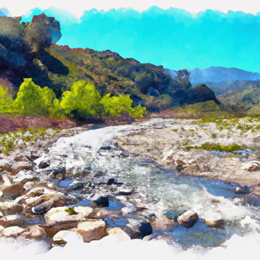
Filaree Flat To Confluence With Bear Creek
This segment of the Whitewater River is rated as a Class III-IV, with challenging rapids and obstacles such as the "Cleavage," "Boulder Garden," and "Pinball." The total mileage for this run is approximately 10 miles.
There are specific regulations in place for this area, including the requirement for all boaters to wear personal flotation devices and to carry a whistle, among other safety measures. Additionally, there are restrictions on camping and fires in the surrounding wilderness area.
Sources such as American Whitewater and California Creeks provide reliable information on streamflow, rapids, and regulations for this run. It is important for boaters to check current conditions and adhere to all safety guidelines before embarking on this exciting whitewater adventure.
Plan your run down to the hour
Same weather feed Snoflo's iOS app uses -- updated continuously from NOAA / yr.no. Watch the precipitation column on the meteogram; rain ahead of a run typically lifts flows 12-48 hours later depending on the basin.
Next 5 days, hour by hour
Temperature line with weather symbols on top, snow + rain accumulation as columns, humidity as a dotted line.
5-day forecast table
Every 3 hours, broken out across temperature, snow, rain, humidity, and wind. Each cell is colour-coded relative to the column min/max.
| Time | Condition | Temp (°F) | Snow (in) | Rain (in) | Humidity (%) | Wind (mps) | Wind dir |
|---|---|---|---|---|---|---|---|
| Loading detailed forecast… | |||||||
15-day temperature & precipitation
Daily temperatures, snow, and rain projected over the next two weeks -- the upstream story that drives next week's flows.
Regional streamflow levels
USGS streamgauges around Filaree Flat To Confluence With Bear Creek -- useful for spotting upstream pulses and gauging which tributary is contributing what.
| Streamgauge | Discharge | View |
|---|---|---|
| Sar Supp Gage Nr Mentone Ca | 26 cfs | → |
| Santa Ana R Nr Mentone (River Only) Ca | 32 cfs | → |
| Plunge C Nr East Highlands Ca | 1 cfs | → |
| City C Nr Highland Ca | 0 cfs | → |
| Sand Canyon C Nr Highland Ca | 1 cfs | → |
| E Twin C Nr Arrowhead Springs Ca | 0 cfs | → |
Plan a longer trip
The closest boat launches, other paddle runs, and campgrounds so a day on the water can grow into a full weekend.
Boat launches
- Pleasure Point Landing
- Holloway's Marina, Inc.
- Duane Boyer (West)
- Big Bear Marina
- Pine Knot Landing
- Carol Morrison (East)
Other river runs
- Big Bear Dam To Private Land In Sec 19, T1n, R1w
- Big Meadows To Filaree Flat
- Bluff Lake To Confluence With Bear Creek
- Below Deep Creek Lake To Below 2w01 Crossing
- Nfsr 3n16 To Confluence With Deep Creek
Campgrounds
- Keller Peak Yellow Post #9
- Siberia Creek Trail Camp
- Shady Cove Group Campground
- Mountain Home Flat
- Keller Peak Yellow Post #8
- Yellow Post #28
Fishing spots
Whitewater safety
- Check the flow before you run
- Use the linked-gauge card and Regional Flow panel above. Class ratings change with flow -- a Class III at low water can become Class IV+ at high water.
- Know your skill ceiling
- Pick runs comfortably below your ceiling. Cold-water and big-water runs raise the consequences of any mistake.
- Wear the right gear
- Helmet, PFD, drysuit / wetsuit when water is below 60°F. Throw bag, knife, and whistle on your person, not in the boat.
- Scout, set safety, and run with a team
- Scout new rapids on foot, set safety with throw bags above the consequence pool, and run with at least one other competent paddler.
- Respect the river
- Strainers, undercuts, low-head dams, and wood can kill at any class rating. When in doubt, portage.
Set push alerts in the Snoflo app
Save Filaree Flat To Confluence With Bear Creek as a favorite, set a discharge threshold (e.g. "alert me when flow hits 600 cfs"), and the iOS app pushes the moment the linked gauge crosses.
About Filaree Flat To Confluence With Bear Creek
What's the optimal flow for Filaree Flat To Confluence With Bear Creek?
The optimal flow depends on the section and the craft. Check the Run Details panel for the linked gauge and current status.
How fresh is the cfs reading on this page?
The linked USGS streamgauge reports continuously (every 15 minutes); Snoflo refreshes throughout the day. Hover the streamflow sparkline to read individual datapoints.
What's the whitewater class?
See the Run Details panel for the class rating Snoflo tracks for this run. Class ratings change with flow -- a Class III at low water can become Class IV in high water.
Where do I put in / take out?
Tap Directions in the hero above to open driving directions to the put-in. For shuttle planning, check the Nearby Boat Launches panel and the river run operator's site.
Can I get alerts when flows hit the optimal range?
Yes -- alerts are managed in the Snoflo iOS app. Favorite this run, set a discharge threshold, and you'll get a push the moment the gauge crosses.
Other runs near here
Snoflo-tracked paddle runs within driving distance of Filaree Flat To Confluence With Bear Creek.