Honeydew Creek River Run
Community Reviews
Been here? Share the conditions.
Reviews, ratings & photos are added in the free Snoflo iOS app — rate a spot, tag the conditions, and your visit is verified by location. Add or manage your reviews from the app.
Honeydew Creek
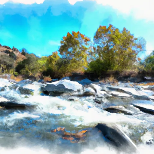
Honeydew Creek is a popular whitewater river run located in Northern California, specifically within the Six Rivers National Forest. The ideal streamflow range for Honeydew Creek is between 250 and 1,000 cubic feet per second (cfs), which usually occurs during the spring and early summer months. The creek is rated as Class III-IV, making it suitable for intermediate and advanced paddlers. Honeydew Creek has a segment mileage of approximately 10 miles, starting at the confluence of Bull Creek and ending at the South Fork Eel River.
The river is known for its challenging rapids, including The Squeeze, a narrow section with boulder obstacles, and the Class IV+ drop known as The Elevator. Other notable rapids include Staircase, Double Trouble, and Hells Kitchen. Honeydew Creek is surrounded by a lush forest, offering scenic views and diverse wildlife.
It is important to note that Honeydew Creek is within the Six Rivers National Forest, which means that certain regulations apply. These include following Leave No Trace principles, obtaining a permit for overnight camping, and respecting wildlife and vegetation. Additionally, visitors are required to have a valid California fishing license if fishing in the creek.
Overall, Honeydew Creek offers a thrilling and scenic whitewater experience for intermediate and advanced paddlers. It is important to check current streamflow conditions and follow all regulations before embarking on a trip down the creek.
Plan your run down to the hour
Same weather feed Snoflo's iOS app uses -- updated continuously from NOAA / yr.no. Watch the precipitation column on the meteogram; rain ahead of a run typically lifts flows 12-48 hours later depending on the basin.
Next 5 days, hour by hour
Temperature line with weather symbols on top, snow + rain accumulation as columns, humidity as a dotted line.
5-day forecast table
Every 3 hours, broken out across temperature, snow, rain, humidity, and wind. Each cell is colour-coded relative to the column min/max.
| Time | Condition | Temp (°F) | Snow (in) | Rain (in) | Humidity (%) | Wind (mps) | Wind dir |
|---|---|---|---|---|---|---|---|
| Loading detailed forecast… | |||||||
15-day temperature & precipitation
Daily temperatures, snow, and rain projected over the next two weeks -- the upstream story that drives next week's flows.
Regional streamflow levels
USGS streamgauges around Honeydew Creek -- useful for spotting upstream pulses and gauging which tributary is contributing what.
| Streamgauge | Discharge | View |
|---|---|---|
| Mattole R Nr Ettersburg Ca | 11 cfs | → |
| Mattole R Nr Petrolia Ca | 34 cfs | → |
| Bull C Nr Weott Ca | 1 cfs | → |
| Sf Eel R Nr Miranda Ca | 42 cfs | → |
| Eel R A Scotia Ca | 219 cfs | → |
| Van Duzen R Nr Bridgeville Ca | 13 cfs | → |
Plan a longer trip
The closest boat launches, other paddle runs, and campgrounds so a day on the water can grow into a full weekend.
Other river runs
- Southwest 1/4 Of Sec. 36 T3s, R1w, Hm To To Its Junction Woth Main Stem
- From Its Headwaters In Sec 1, T4s, R1w, Hm To To The Pacific Ocean
- Southeast 1/4 Of Sec 25 T3s, R1w, Hm To To Its Junction With The Main Stem
- Bear Creek, North Fork
- From Its Headwaters In Sec. 6, T4s, R1e, Hm To To Junction With Main Stem In Sec. 9 T4s, R1e, Hm
Campgrounds
Parks
Whitewater safety
- Check the flow before you run
- Use the linked-gauge card and Regional Flow panel above. Class ratings change with flow -- a Class III at low water can become Class IV+ at high water.
- Know your skill ceiling
- Pick runs comfortably below your ceiling. Cold-water and big-water runs raise the consequences of any mistake.
- Wear the right gear
- Helmet, PFD, drysuit / wetsuit when water is below 60°F. Throw bag, knife, and whistle on your person, not in the boat.
- Scout, set safety, and run with a team
- Scout new rapids on foot, set safety with throw bags above the consequence pool, and run with at least one other competent paddler.
- Respect the river
- Strainers, undercuts, low-head dams, and wood can kill at any class rating. When in doubt, portage.
Set push alerts in the Snoflo app
Save Honeydew Creek as a favorite, set a discharge threshold (e.g. "alert me when flow hits 600 cfs"), and the iOS app pushes the moment the linked gauge crosses.
About Honeydew Creek
What's the optimal flow for Honeydew Creek?
The optimal flow depends on the section and the craft. Check the Run Details panel for the linked gauge and current status.
How fresh is the cfs reading on this page?
The linked USGS streamgauge reports continuously (every 15 minutes); Snoflo refreshes throughout the day. Hover the streamflow sparkline to read individual datapoints.
What's the whitewater class?
See the Run Details panel for the class rating Snoflo tracks for this run. Class ratings change with flow -- a Class III at low water can become Class IV in high water.
Where do I put in / take out?
Tap Directions in the hero above to open driving directions to the put-in. For shuttle planning, check the Nearby Boat Launches panel and the river run operator's site.
Can I get alerts when flows hit the optimal range?
Yes -- alerts are managed in the Snoflo iOS app. Favorite this run, set a discharge threshold, and you'll get a push the moment the gauge crosses.
Other runs near here
Snoflo-tracked paddle runs within driving distance of Honeydew Creek.