Coffee Pot Campground To Mccrea's Bridge River Run
Community Reviews
Been here? Share the conditions.
Reviews, ratings & photos are added in the free Snoflo iOS app — rate a spot, tag the conditions, and your visit is verified by location. Add or manage your reviews from the app.
Coffee Pot Campground To Mccrea's Bridge
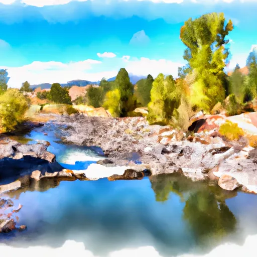
This segment is 9.6 miles long and has several exciting rapids, including Little Falls, Devil's Teeth, and The Narrows. Little Falls is a Class IV rapid with a steep drop and a tight channel. Devil's Teeth is a Class III rapid with several large boulders, creating a technical run. The Narrows is a Class IV rapid with a series of drops and narrow channels.
There are some specific regulations to the area that river runners should be aware of. Permits are required for overnight camping in designated sites along the river. Fires are not allowed, and all waste must be carried out. Additionally, boats must have a permit and be inspected for invasive species before entering the river.
Overall, the Whitewater River run from Coffee Pot Campground to McCrea's Bridge offers a fun and challenging adventure for experienced river runners. It is important to check the streamflow levels and follow all regulations to ensure a safe and enjoyable trip.
Plan your run down to the hour
Same weather feed Snoflo's iOS app uses -- updated continuously from NOAA / yr.no. Watch the precipitation column on the meteogram; rain ahead of a run typically lifts flows 12-48 hours later depending on the basin.
Next 5 days, hour by hour
Temperature line with weather symbols on top, snow + rain accumulation as columns, humidity as a dotted line.
5-day forecast table
Every 3 hours, broken out across temperature, snow, rain, humidity, and wind. Each cell is colour-coded relative to the column min/max.
| Time | Condition | Temp (°F) | Snow (in) | Rain (in) | Humidity (%) | Wind (mps) | Wind dir |
|---|---|---|---|---|---|---|---|
| Loading detailed forecast… | |||||||
15-day temperature & precipitation
Daily temperatures, snow, and rain projected over the next two weeks -- the upstream story that drives next week's flows.
Regional streamflow levels
USGS streamgauges around Coffee Pot Campground To Mccrea's Bridge -- useful for spotting upstream pulses and gauging which tributary is contributing what.
| Streamgauge | Discharge | View |
|---|---|---|
| Henrys Fork Blw Coffee Pot Rapids Nr Macks Inn Id | 372 cfs | → |
| Henrys Fork Nr Island Park Id | 1,350 cfs | → |
| Big Springs At Big Springs Id | 128 cfs | → |
| Henrys Fork Nr Lake Id | 214 cfs | → |
| Red Rock Cr Ab Lakes Nr Lakeview Mt | 32 cfs | → |
| Madison River Near West Yellowstone Mt | 322 cfs | → |
Plan a longer trip
The closest boat launches, other paddle runs, and campgrounds so a day on the water can grow into a full weekend.
Boat launches
- Mccrea Road Fremont County
- Mill Creek
- Fremont County
- Forest Road 413 Fremont County
- Buttermilk
- Island Park Boating Site
Other river runs
- Big Springs To Coffee Pot Campground
- Elk Creek To Slackwater Of Ponds Power Dam
- Box Canyon
- Buffalo River Springs To Confluence With Elk Creek
- Coffee Pot
Campgrounds
- Mccrea Bridge Campground
- Mccrea Bridge
- Buttermilk
- Island Park Camp
- Buttermilk Campground
- Upper Coffeepot Campground
Fishing spots
Whitewater safety
- Check the flow before you run
- Use the linked-gauge card and Regional Flow panel above. Class ratings change with flow -- a Class III at low water can become Class IV+ at high water.
- Know your skill ceiling
- Pick runs comfortably below your ceiling. Cold-water and big-water runs raise the consequences of any mistake.
- Wear the right gear
- Helmet, PFD, drysuit / wetsuit when water is below 60°F. Throw bag, knife, and whistle on your person, not in the boat.
- Scout, set safety, and run with a team
- Scout new rapids on foot, set safety with throw bags above the consequence pool, and run with at least one other competent paddler.
- Respect the river
- Strainers, undercuts, low-head dams, and wood can kill at any class rating. When in doubt, portage.
Set push alerts in the Snoflo app
Save Coffee Pot Campground To Mccrea's Bridge as a favorite, set a discharge threshold (e.g. "alert me when flow hits 600 cfs"), and the iOS app pushes the moment the linked gauge crosses.
About Coffee Pot Campground To Mccrea's Bridge
What's the optimal flow for Coffee Pot Campground To Mccrea's Bridge?
The optimal flow depends on the section and the craft. Check the Run Details panel for the linked gauge and current status.
How fresh is the cfs reading on this page?
The linked USGS streamgauge reports continuously (every 15 minutes); Snoflo refreshes throughout the day. Hover the streamflow sparkline to read individual datapoints.
What's the whitewater class?
See the Run Details panel for the class rating Snoflo tracks for this run. Class ratings change with flow -- a Class III at low water can become Class IV in high water.
Where do I put in / take out?
Tap Directions in the hero above to open driving directions to the put-in. For shuttle planning, check the Nearby Boat Launches panel and the river run operator's site.
Can I get alerts when flows hit the optimal range?
Yes -- alerts are managed in the Snoflo iOS app. Favorite this run, set a discharge threshold, and you'll get a push the moment the gauge crosses.
Other runs near here
Snoflo-tracked paddle runs within driving distance of Coffee Pot Campground To Mccrea's Bridge.