Western Boundary Line Of Section 34 To Redfish Lake River Run
Community Reviews
Been here? Share the conditions.
Reviews, ratings & photos are added in the free Snoflo iOS app — rate a spot, tag the conditions, and your visit is verified by location. Add or manage your reviews from the app.
Western Boundary Line Of Section 34 To Redfish Lake
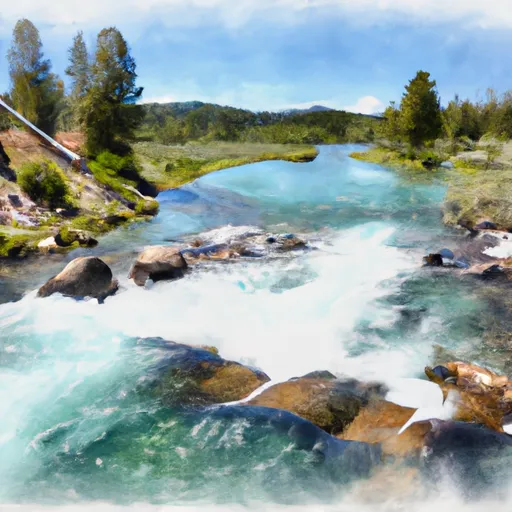
The Pinball Rapid is a challenging section of the river that requires skillful maneuvering of boats through a tight channel with several rocks and boulders. The S-Turn Rapid is another challenging section that requires quick decision-making and precise maneuvering. The Lunch Counter Rapid is the most significant rapid on the Whitewater River Run, which is known for its massive waves that can reach up to 20 feet high.
The specific regulations to the area include the use of personal flotation devices (PFDs) for all boaters, and a permit is required to access the area. Additionally, the use of alcohol and drugs is strictly prohibited on the river. The local authorities enforce these regulations to ensure the safety of the visitors and preserve the natural environment.
In conclusion, the Whitewater River Run from the Western Boundary Line of Section 34 to Redfish Lake offers an exhilarating experience to kayakers and rafters. With appropriate knowledge of the ideal streamflow range, class rating, segment mileage, specific river rapids/obstacles, and specific regulations to the area, visitors can enjoy the adventure safely and responsibly.
Plan your run down to the hour
Same weather feed Snoflo's iOS app uses -- updated continuously from NOAA / yr.no. Watch the precipitation column on the meteogram; rain ahead of a run typically lifts flows 12-48 hours later depending on the basin.
Next 5 days, hour by hour
Temperature line with weather symbols on top, snow + rain accumulation as columns, humidity as a dotted line.
5-day forecast table
Every 3 hours, broken out across temperature, snow, rain, humidity, and wind. Each cell is colour-coded relative to the column min/max.
| Time | Condition | Temp (°F) | Snow (in) | Rain (in) | Humidity (%) | Wind (mps) | Wind dir |
|---|---|---|---|---|---|---|---|
| Loading detailed forecast… | |||||||
15-day temperature & precipitation
Daily temperatures, snow, and rain projected over the next two weeks -- the upstream story that drives next week's flows.
Regional streamflow levels
USGS streamgauges around Western Boundary Line Of Section 34 To Redfish Lake -- useful for spotting upstream pulses and gauging which tributary is contributing what.
| Streamgauge | Discharge | View |
|---|---|---|
| Valley Creek At Stanley Id | 132 cfs | → |
| Salmon River Bl Yankee Fork Nr Clayton Id | 648 cfs | → |
| Yankee Fork Salmon River Nr Clayton Id | 99 cfs | → |
| Thompson Creek Nr Clayton Id | 5 cfs | → |
| Squaw Creek Bl Bruno Creek Nr Clayton Id | 10 cfs | → |
| Sf Payette River At Lowman Id | 520 cfs | → |
Plan a longer trip
The closest boat launches, other paddle runs, and campgrounds so a day on the water can grow into a full weekend.
Boat launches
Other river runs
- Headwaters To Western Boundary Line Of Section 34
- Outlet Redfish Lake To Confluence With Salmon River
- Headwaters To Inlet Redfish Lake
- Headwaters To Western Boundary Line Of Section 17
- Headwaters (Gold Creek To Stanley)
Campgrounds
- Point Campground
- Point
- Glacier View Campground
- Redfish Outlet Campground
- Redfish Outlet
- Outlet Campground
Fishing spots
Points of interest
Whitewater safety
- Check the flow before you run
- Use the linked-gauge card and Regional Flow panel above. Class ratings change with flow -- a Class III at low water can become Class IV+ at high water.
- Know your skill ceiling
- Pick runs comfortably below your ceiling. Cold-water and big-water runs raise the consequences of any mistake.
- Wear the right gear
- Helmet, PFD, drysuit / wetsuit when water is below 60°F. Throw bag, knife, and whistle on your person, not in the boat.
- Scout, set safety, and run with a team
- Scout new rapids on foot, set safety with throw bags above the consequence pool, and run with at least one other competent paddler.
- Respect the river
- Strainers, undercuts, low-head dams, and wood can kill at any class rating. When in doubt, portage.
Set push alerts in the Snoflo app
Save Western Boundary Line Of Section 34 To Redfish Lake as a favorite, set a discharge threshold (e.g. "alert me when flow hits 600 cfs"), and the iOS app pushes the moment the linked gauge crosses.
About Western Boundary Line Of Section 34 To Redfish Lake
What's the optimal flow for Western Boundary Line Of Section 34 To Redfish Lake?
The optimal flow depends on the section and the craft. Check the Run Details panel for the linked gauge and current status.
How fresh is the cfs reading on this page?
The linked USGS streamgauge reports continuously (every 15 minutes); Snoflo refreshes throughout the day. Hover the streamflow sparkline to read individual datapoints.
What's the whitewater class?
See the Run Details panel for the class rating Snoflo tracks for this run. Class ratings change with flow -- a Class III at low water can become Class IV in high water.
Where do I put in / take out?
Tap Directions in the hero above to open driving directions to the put-in. For shuttle planning, check the Nearby Boat Launches panel and the river run operator's site.
Can I get alerts when flows hit the optimal range?
Yes -- alerts are managed in the Snoflo iOS app. Favorite this run, set a discharge threshold, and you'll get a push the moment the gauge crosses.
Other runs near here
Snoflo-tracked paddle runs within driving distance of Western Boundary Line Of Section 34 To Redfish Lake.