Headwaters To Wilderness Boundary River Run
Community Reviews
Been here? Share the conditions.
Reviews, ratings & photos are added in the free Snoflo iOS app — rate a spot, tag the conditions, and your visit is verified by location. Add or manage your reviews from the app.
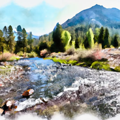
Headwaters To Wilderness Boundary
This section stretches for 28 miles, starting at the Headwaters and running all the way to the Wilderness Boundary. Along the way, there are numerous rapids and obstacles to navigate, including Big Bend, S-Turn, and Box Canyon. These rapids range in difficulty, with some requiring precise maneuvering and others simply requiring a strong paddle.
In order to protect the natural beauty and integrity of the river, there are specific regulations in place for this area. These include a limit on the number of permits issued per day, as well as restrictions on camping and fires. It is important for those planning to run this section of the Whitewater River to familiarize themselves with these regulations and to obtain the necessary permits before embarking on their journey.
Plan your run down to the hour
Same weather feed Snoflo's iOS app uses -- updated continuously from NOAA / yr.no. Watch the precipitation column on the meteogram; rain ahead of a run typically lifts flows 12-48 hours later depending on the basin.
Next 5 days, hour by hour
Temperature line with weather symbols on top, snow + rain accumulation as columns, humidity as a dotted line.
5-day forecast table
Every 3 hours, broken out across temperature, snow, rain, humidity, and wind. Each cell is colour-coded relative to the column min/max.
| Time | Condition | Temp (°F) | Snow (in) | Rain (in) | Humidity (%) | Wind (mps) | Wind dir |
|---|---|---|---|---|---|---|---|
| Loading detailed forecast… | |||||||
15-day temperature & precipitation
Daily temperatures, snow, and rain projected over the next two weeks -- the upstream story that drives next week's flows.
Regional streamflow levels
USGS streamgauges around Headwaters To Wilderness Boundary -- useful for spotting upstream pulses and gauging which tributary is contributing what.
| Streamgauge | Discharge | View |
|---|---|---|
| Valley Creek At Stanley Id | 124 cfs | → |
| Salmon River Bl Yankee Fork Nr Clayton Id | 590 cfs | → |
| Yankee Fork Salmon River Nr Clayton Id | 94 cfs | → |
| Mf Salmon River At Mf Lodge Nr Yellow Pine Id | 759 cfs | → |
| Deadwood River Bl Deadwood Res Nr Lowman Id | 848 cfs | → |
| Sf Payette River At Lowman Id | 500 cfs | → |
Plan a longer trip
The closest boat launches, other paddle runs, and campgrounds so a day on the water can grow into a full weekend.
Other river runs
- Wilderness Boundary To Confluence With Middle Fork Salmon River
- Fir Creek Campground To Boise Nf Boundary
- Elk Creek To Fir Creek Campground
- Headwaters To Elk Meadow Trailhead
- Headwaters To 1 Mile Downstream Of Soldier Lake
Campgrounds
- Lola Creek Campground
- Lola Creek C/G
- Thatcher Campground
- Thatcher Creek Campground
- Thatcher C/G
- Cape Horn Winter Rental Cabin
Whitewater safety
- Check the flow before you run
- Use the linked-gauge card and Regional Flow panel above. Class ratings change with flow -- a Class III at low water can become Class IV+ at high water.
- Know your skill ceiling
- Pick runs comfortably below your ceiling. Cold-water and big-water runs raise the consequences of any mistake.
- Wear the right gear
- Helmet, PFD, drysuit / wetsuit when water is below 60°F. Throw bag, knife, and whistle on your person, not in the boat.
- Scout, set safety, and run with a team
- Scout new rapids on foot, set safety with throw bags above the consequence pool, and run with at least one other competent paddler.
- Respect the river
- Strainers, undercuts, low-head dams, and wood can kill at any class rating. When in doubt, portage.
Set push alerts in the Snoflo app
Save Headwaters To Wilderness Boundary as a favorite, set a discharge threshold (e.g. "alert me when flow hits 600 cfs"), and the iOS app pushes the moment the linked gauge crosses.
About Headwaters To Wilderness Boundary
What's the optimal flow for Headwaters To Wilderness Boundary?
The optimal flow depends on the section and the craft. Check the Run Details panel for the linked gauge and current status.
How fresh is the cfs reading on this page?
The linked USGS streamgauge reports continuously (every 15 minutes); Snoflo refreshes throughout the day. Hover the streamflow sparkline to read individual datapoints.
What's the whitewater class?
See the Run Details panel for the class rating Snoflo tracks for this run. Class ratings change with flow -- a Class III at low water can become Class IV in high water.
Where do I put in / take out?
Tap Directions in the hero above to open driving directions to the put-in. For shuttle planning, check the Nearby Boat Launches panel and the river run operator's site.
Can I get alerts when flows hit the optimal range?
Yes -- alerts are managed in the Snoflo iOS app. Favorite this run, set a discharge threshold, and you'll get a push the moment the gauge crosses.
Other runs near here
Snoflo-tracked paddle runs within driving distance of Headwaters To Wilderness Boundary.