Idaho State Line To Confluence With Beaver Creek River Run
Community Reviews
Been here? Share the conditions.
Reviews, ratings & photos are added in the free Snoflo iOS app — rate a spot, tag the conditions, and your visit is verified by location. Add or manage your reviews from the app.
Idaho State Line To Confluence With Beaver Creek
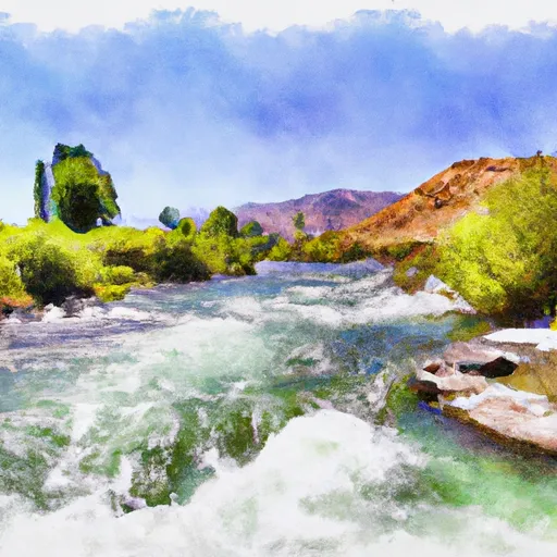
As for specific rapids and obstacles, the Whitewater River Run features several exciting sections. The first rapid, known as "Deadwood Falls," is a Class III rapid that requires skilled maneuvering to navigate safely. The "Last Chance" rapid is another thrilling section of the run that features large waves and strong currents. Other notable rapids include "Cable Car," "Coyote Creek," and "Screaming Left."
When it comes to regulations for the area, all boaters are required to obtain a permit before embarking on the Whitewater River Run. Additionally, it is important to note that the river can be dangerous at high water levels, so it is recommended to check current conditions and streamflow levels before beginning your journey.
Overall, the Whitewater River Run is an exhilarating adventure that offers intermediate rafters an exciting challenge. With its stunning scenery, challenging rapids, and unique obstacles, this section of the river is a must-visit for any thrill-seeking rafter.
Plan your run down to the hour
Same weather feed Snoflo's iOS app uses -- updated continuously from NOAA / yr.no. Watch the precipitation column on the meteogram; rain ahead of a run typically lifts flows 12-48 hours later depending on the basin.
Next 5 days, hour by hour
Temperature line with weather symbols on top, snow + rain accumulation as columns, humidity as a dotted line.
5-day forecast table
Every 3 hours, broken out across temperature, snow, rain, humidity, and wind. Each cell is colour-coded relative to the column min/max.
| Time | Condition | Temp (°F) | Snow (in) | Rain (in) | Humidity (%) | Wind (mps) | Wind dir |
|---|---|---|---|---|---|---|---|
| Loading detailed forecast… | |||||||
15-day temperature & precipitation
Daily temperatures, snow, and rain projected over the next two weeks -- the upstream story that drives next week's flows.
Regional streamflow levels
USGS streamgauges around Idaho State Line To Confluence With Beaver Creek -- useful for spotting upstream pulses and gauging which tributary is contributing what.
| Streamgauge | Discharge | View |
|---|---|---|
| Logan | 71 cfs | → |
| Logan River Above State Dam | 85 cfs | → |
| Bear River At Idaho-Utah State Line | 961 cfs | → |
| Blacksmith Fork Ab U.P.&L. Co | 53 cfs | → |
| Big Creek Near Randolph | 3 cfs | → |
| Little Bear River At Paradise | 20 cfs | → |
Plan a longer trip
The closest boat launches, other paddle runs, and campgrounds so a day on the water can grow into a full weekend.
Boat launches
- Bear Lake State Park
- Rendezvous Beach State Park
- North Cisco Road Rich County
- Lamont Reservoir
- Glendale Reservoir
- East Shore Marina
Other river runs
Campgrounds
- Red Banks Campground
- Lewis M. Turner Campground
- Tony Grove Lake Campground
- Tony Grove Lake
- Sunrise Campground
- High Creek
Whitewater safety
- Check the flow before you run
- Use the linked-gauge card and Regional Flow panel above. Class ratings change with flow -- a Class III at low water can become Class IV+ at high water.
- Know your skill ceiling
- Pick runs comfortably below your ceiling. Cold-water and big-water runs raise the consequences of any mistake.
- Wear the right gear
- Helmet, PFD, drysuit / wetsuit when water is below 60°F. Throw bag, knife, and whistle on your person, not in the boat.
- Scout, set safety, and run with a team
- Scout new rapids on foot, set safety with throw bags above the consequence pool, and run with at least one other competent paddler.
- Respect the river
- Strainers, undercuts, low-head dams, and wood can kill at any class rating. When in doubt, portage.
Set push alerts in the Snoflo app
Save Idaho State Line To Confluence With Beaver Creek as a favorite, set a discharge threshold (e.g. "alert me when flow hits 600 cfs"), and the iOS app pushes the moment the linked gauge crosses.
About Idaho State Line To Confluence With Beaver Creek
What's the optimal flow for Idaho State Line To Confluence With Beaver Creek?
The optimal flow depends on the section and the craft. Check the Run Details panel for the linked gauge and current status.
How fresh is the cfs reading on this page?
The linked USGS streamgauge reports continuously (every 15 minutes); Snoflo refreshes throughout the day. Hover the streamflow sparkline to read individual datapoints.
What's the whitewater class?
See the Run Details panel for the class rating Snoflo tracks for this run. Class ratings change with flow -- a Class III at low water can become Class IV in high water.
Where do I put in / take out?
Tap Directions in the hero above to open driving directions to the put-in. For shuttle planning, check the Nearby Boat Launches panel and the river run operator's site.
Can I get alerts when flows hit the optimal range?
Yes -- alerts are managed in the Snoflo iOS app. Favorite this run, set a discharge threshold, and you'll get a push the moment the gauge crosses.
Other runs near here
Snoflo-tracked paddle runs within driving distance of Idaho State Line To Confluence With Beaver Creek.