Cow Creek River Run
Community Reviews
Been here? Share the conditions.
Reviews, ratings & photos are added in the free Snoflo iOS app — rate a spot, tag the conditions, and your visit is verified by location. Add or manage your reviews from the app.
Cow Creek
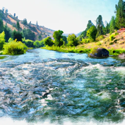
Cow Creek is a popular whitewater river run located in the state of Idaho. The ideal streamflow range for this river is between 600-1500 cfs. The class rating for Cow Creek is Class II-III, which means it is suitable for intermediate paddlers with some experience. The segment mileage for Cow Creek is approximately 6 miles.
Cow Creek has several notable rapids and obstacles, including the "Squeeze," a narrow chute that requires precise maneuvering. There is also a series of drops and ledges known as "The Rodeo" that can be challenging during high water flows.
In terms of regulations, Cow Creek is located within the boundaries of the Nez Perce-Clearwater National Forests, and access is regulated by the Forest Service. A permit is required for overnight camping along the river, and visitors are expected to follow Leave No Trace principles and pack out all trash.
Overall, Cow Creek offers an exciting and challenging whitewater experience for intermediate paddlers. However, it is important to check current streamflow conditions and be prepared for potential hazards on the river.
Plan your run down to the hour
Same weather feed Snoflo's iOS app uses -- updated continuously from NOAA / yr.no. Watch the precipitation column on the meteogram; rain ahead of a run typically lifts flows 12-48 hours later depending on the basin.
Next 5 days, hour by hour
Temperature line with weather symbols on top, snow + rain accumulation as columns, humidity as a dotted line.
5-day forecast table
Every 3 hours, broken out across temperature, snow, rain, humidity, and wind. Each cell is colour-coded relative to the column min/max.
| Time | Condition | Temp (°F) | Snow (in) | Rain (in) | Humidity (%) | Wind (mps) | Wind dir |
|---|---|---|---|---|---|---|---|
| Loading detailed forecast… | |||||||
15-day temperature & precipitation
Daily temperatures, snow, and rain projected over the next two weeks -- the upstream story that drives next week's flows.
Regional streamflow levels
USGS streamgauges around Cow Creek -- useful for spotting upstream pulses and gauging which tributary is contributing what.
| Streamgauge | Discharge | View |
|---|---|---|
| Pahsimeroi River At Ellis Id | 111 cfs | → |
| Lemhi River Nr Lemhi Id | 121 cfs | → |
| Lemhi River Below L5 Diversion Near Salmon | 55 cfs | → |
| Blackbird Creek Near Cobalt | 12 cfs | → |
| Salmon River At Salmon Id | 1,530 cfs | → |
| Napias Creek Below Arnett Creek Near Leesburg | 23 cfs | → |
Plan a longer trip
The closest boat launches, other paddle runs, and campgrounds so a day on the water can grow into a full weekend.
Other river runs
- Colston To The Town Of Salmon
- Pahsimeroi To Royal Gorge
- Salmon River
- Bear Valley Lake To Trailhead
- Headwaters To Wade Creek
Whitewater safety
- Check the flow before you run
- Use the linked-gauge card and Regional Flow panel above. Class ratings change with flow -- a Class III at low water can become Class IV+ at high water.
- Know your skill ceiling
- Pick runs comfortably below your ceiling. Cold-water and big-water runs raise the consequences of any mistake.
- Wear the right gear
- Helmet, PFD, drysuit / wetsuit when water is below 60°F. Throw bag, knife, and whistle on your person, not in the boat.
- Scout, set safety, and run with a team
- Scout new rapids on foot, set safety with throw bags above the consequence pool, and run with at least one other competent paddler.
- Respect the river
- Strainers, undercuts, low-head dams, and wood can kill at any class rating. When in doubt, portage.
Set push alerts in the Snoflo app
Save Cow Creek as a favorite, set a discharge threshold (e.g. "alert me when flow hits 600 cfs"), and the iOS app pushes the moment the linked gauge crosses.
About Cow Creek
What's the optimal flow for Cow Creek?
The optimal flow depends on the section and the craft. Check the Run Details panel for the linked gauge and current status.
How fresh is the cfs reading on this page?
The linked USGS streamgauge reports continuously (every 15 minutes); Snoflo refreshes throughout the day. Hover the streamflow sparkline to read individual datapoints.
What's the whitewater class?
See the Run Details panel for the class rating Snoflo tracks for this run. Class ratings change with flow -- a Class III at low water can become Class IV in high water.
Where do I put in / take out?
Tap Directions in the hero above to open driving directions to the put-in. For shuttle planning, check the Nearby Boat Launches panel and the river run operator's site.
Can I get alerts when flows hit the optimal range?
Yes -- alerts are managed in the Snoflo iOS app. Favorite this run, set a discharge threshold, and you'll get a push the moment the gauge crosses.
Other runs near here
Snoflo-tracked paddle runs within driving distance of Cow Creek.