South Fork Snake River River Run
Community Reviews
Been here? Share the conditions.
Reviews, ratings & photos are added in the free Snoflo iOS app — rate a spot, tag the conditions, and your visit is verified by location. Add or manage your reviews from the app.
South Fork Snake River
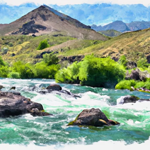
The segment mileage for the South Fork Snake River run is approximately 64 miles, with several scenic areas and challenging rapids such as the Big Kahuna, the Lunch Counter, and the Cottonwood Rapids. The river also features stunning views of the Teton Range and the surrounding wilderness.
Regulations for this area include a mandatory life jacket requirement for all participants, a limit on the number of people per raft, and a prohibition on alcohol and drugs. It is important to follow all regulations and guidelines to ensure a safe and enjoyable experience on the river.
Overall, the South Fork Snake River run is an exciting and challenging adventure for experienced whitewater rafters. Proper preparation and adherence to regulations will ensure a safe and enjoyable trip on this beautiful river.
Plan your run down to the hour
Same weather feed Snoflo's iOS app uses -- updated continuously from NOAA / yr.no. Watch the precipitation column on the meteogram; rain ahead of a run typically lifts flows 12-48 hours later depending on the basin.
Next 5 days, hour by hour
Temperature line with weather symbols on top, snow + rain accumulation as columns, humidity as a dotted line.
5-day forecast table
Every 3 hours, broken out across temperature, snow, rain, humidity, and wind. Each cell is colour-coded relative to the column min/max.
| Time | Condition | Temp (°F) | Snow (in) | Rain (in) | Humidity (%) | Wind (mps) | Wind dir |
|---|---|---|---|---|---|---|---|
| Loading detailed forecast… | |||||||
15-day temperature & precipitation
Daily temperatures, snow, and rain projected over the next two weeks -- the upstream story that drives next week's flows.
Regional streamflow levels
USGS streamgauges around South Fork Snake River -- useful for spotting upstream pulses and gauging which tributary is contributing what.
| Streamgauge | Discharge | View |
|---|---|---|
| Snake River Nr Irwin Id | 9,380 cfs | → |
| Snake River Nr Heise Id | 11,600 cfs | → |
| Willow Creek Bl Tex Creek Nr Ririe Id | 7 cfs | → |
| Willow Creek Nr Ririe Id | 81 cfs | → |
| Dry Bed Nr Ririe Id | 2,290 cfs | → |
| Teton River Ab South Leigh Creek Nr Driggs Id | 310 cfs | → |
Plan a longer trip
The closest boat launches, other paddle runs, and campgrounds so a day on the water can grow into a full weekend.
Boat launches
- Conant Valley Boat Ramp
- Spring Creek Boat Ramp Swan Valley
- Wolf Flats Recreation Area
- Palisades Creek
- Byington Boat Ramp
- Dam Access
Other river runs
- Tie Canyon To Targhee Nf Boundary
- Pine Creek To Riley Diversion
- Just West Of Crystal Lake To Trailhead
- Palisades Dam To Confluence With Pine Creek
- Confluence Of North Fork Palisades Creek And Corral Canyon To Palisades Campground
Campgrounds
Points of interest
Whitewater safety
- Check the flow before you run
- Use the linked-gauge card and Regional Flow panel above. Class ratings change with flow -- a Class III at low water can become Class IV+ at high water.
- Know your skill ceiling
- Pick runs comfortably below your ceiling. Cold-water and big-water runs raise the consequences of any mistake.
- Wear the right gear
- Helmet, PFD, drysuit / wetsuit when water is below 60°F. Throw bag, knife, and whistle on your person, not in the boat.
- Scout, set safety, and run with a team
- Scout new rapids on foot, set safety with throw bags above the consequence pool, and run with at least one other competent paddler.
- Respect the river
- Strainers, undercuts, low-head dams, and wood can kill at any class rating. When in doubt, portage.
Set push alerts in the Snoflo app
Save South Fork Snake River as a favorite, set a discharge threshold (e.g. "alert me when flow hits 600 cfs"), and the iOS app pushes the moment the linked gauge crosses.
About South Fork Snake River
What's the optimal flow for South Fork Snake River?
The optimal flow depends on the section and the craft. Check the Run Details panel for the linked gauge and current status.
How fresh is the cfs reading on this page?
The linked USGS streamgauge reports continuously (every 15 minutes); Snoflo refreshes throughout the day. Hover the streamflow sparkline to read individual datapoints.
What's the whitewater class?
See the Run Details panel for the class rating Snoflo tracks for this run. Class ratings change with flow -- a Class III at low water can become Class IV in high water.
Where do I put in / take out?
Tap Directions in the hero above to open driving directions to the put-in. For shuttle planning, check the Nearby Boat Launches panel and the river run operator's site.
Can I get alerts when flows hit the optimal range?
Yes -- alerts are managed in the Snoflo iOS app. Favorite this run, set a discharge threshold, and you'll get a push the moment the gauge crosses.
Other runs near here
Snoflo-tracked paddle runs within driving distance of South Fork Snake River.