Miller Creek, Sec. 13, T4s, R21e To Bramble Creek, Sec. 26, T5s, R12e River Run
Community Reviews
Been here? Share the conditions.
Reviews, ratings & photos are added in the free Snoflo iOS app — rate a spot, tag the conditions, and your visit is verified by location. Add or manage your reviews from the app.
Miller Creek, Sec. 13, T4s, R21e To Bramble Creek, Sec. 26, T5s, R12e
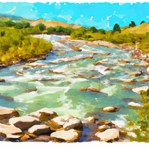
There are several notable rapids and obstacles on this stretch of the Whitewater River, including Pinball, Twin Bridges, and Powerhouse. Pinball is a Class III rapid that is known for its technicality and narrow channel. Twin Bridges is another Class III rapid that requires paddlers to navigate between two large boulders. Powerhouse is a Class II rapid that features a large wave train.
It is important to note that there are specific regulations in place for this area. Paddlers are required to wear appropriate safety gear, including a PFD and helmet. Additionally, motorized vehicles are not allowed on the river, and camping is only allowed in designated areas.
Overall, the Whitewater River run is a scenic and challenging stretch of river that is popular among intermediate paddlers. Paddlers should be aware of the specific regulations and recommended streamflow range before embarking on this adventure. Sources used for verification include American Whitewater and Montana River Action.
Plan your run down to the hour
Same weather feed Snoflo's iOS app uses -- updated continuously from NOAA / yr.no. Watch the precipitation column on the meteogram; rain ahead of a run typically lifts flows 12-48 hours later depending on the basin.
Next 5 days, hour by hour
Temperature line with weather symbols on top, snow + rain accumulation as columns, humidity as a dotted line.
5-day forecast table
Every 3 hours, broken out across temperature, snow, rain, humidity, and wind. Each cell is colour-coded relative to the column min/max.
| Time | Condition | Temp (°F) | Snow (in) | Rain (in) | Humidity (%) | Wind (mps) | Wind dir |
|---|---|---|---|---|---|---|---|
| Loading detailed forecast… | |||||||
15-day temperature & precipitation
Daily temperatures, snow, and rain projected over the next two weeks -- the upstream story that drives next week's flows.
Regional streamflow levels
USGS streamgauges around Miller Creek, Sec. 13, T4s, R21e To Bramble Creek, Sec. 26, T5s, R12e -- useful for spotting upstream pulses and gauging which tributary is contributing what.
| Streamgauge | Discharge | View |
|---|---|---|
| Yellowstone River Near Livingston Mt | 3,370 cfs | → |
| West Rosebud Creek Near Roscoe Mt | 375 cfs | → |
| Shields River Nr Livingston Mt | 81 cfs | → |
| Soda Butte Cr At Park Bndry At Silver Gate | 49 cfs | → |
| Boulder River At Big Timber Mt | 260 cfs | → |
| Lamar River Nr Tower Falls Ranger Station Ynp | 391 cfs | → |
Plan a longer trip
The closest boat launches, other paddle runs, and campgrounds so a day on the water can grow into a full weekend.
Other river runs
- Blakley Creek, Sec. 26, T4s, R12e To Miller Creek, Sec 13, T4s, R21e
- Bible Run
- Bramble Creek, Sec. 26, T5s, R12e To Absaroka-Beartooth Wilderness, Sec. 22, T7s, R12e
- Gallatin Forest Boundary, Sec. 26, T3s, R12e To Blakley Creek, Sec. 26, T3s, R12e
- Absaroka-Beartooth Wilderness Boundary To Headwaters, Sec. 9, T9s, R14e
Campgrounds
- Chippy Park
- Chippy Park Campground
- Hells Canyon
- Hell's Canyon Campground
- Hells Canyon Campground
- Aspen Campground
Fishing spots
Whitewater safety
- Check the flow before you run
- Use the linked-gauge card and Regional Flow panel above. Class ratings change with flow -- a Class III at low water can become Class IV+ at high water.
- Know your skill ceiling
- Pick runs comfortably below your ceiling. Cold-water and big-water runs raise the consequences of any mistake.
- Wear the right gear
- Helmet, PFD, drysuit / wetsuit when water is below 60°F. Throw bag, knife, and whistle on your person, not in the boat.
- Scout, set safety, and run with a team
- Scout new rapids on foot, set safety with throw bags above the consequence pool, and run with at least one other competent paddler.
- Respect the river
- Strainers, undercuts, low-head dams, and wood can kill at any class rating. When in doubt, portage.
Set push alerts in the Snoflo app
Save Miller Creek, Sec. 13, T4s, R21e To Bramble Creek, Sec. 26, T5s, R12e as a favorite, set a discharge threshold (e.g. "alert me when flow hits 600 cfs"), and the iOS app pushes the moment the linked gauge crosses.
About Miller Creek, Sec. 13, T4s, R21e To Bramble Creek, Sec. 26, T5s, R12e
What's the optimal flow for Miller Creek, Sec. 13, T4s, R21e To Bramble Creek, Sec. 26, T5s, R12e?
The optimal flow depends on the section and the craft. Check the Run Details panel for the linked gauge and current status.
How fresh is the cfs reading on this page?
The linked USGS streamgauge reports continuously (every 15 minutes); Snoflo refreshes throughout the day. Hover the streamflow sparkline to read individual datapoints.
What's the whitewater class?
See the Run Details panel for the class rating Snoflo tracks for this run. Class ratings change with flow -- a Class III at low water can become Class IV in high water.
Where do I put in / take out?
Tap Directions in the hero above to open driving directions to the put-in. For shuttle planning, check the Nearby Boat Launches panel and the river run operator's site.
Can I get alerts when flows hit the optimal range?
Yes -- alerts are managed in the Snoflo iOS app. Favorite this run, set a discharge threshold, and you'll get a push the moment the gauge crosses.
Other runs near here
Snoflo-tracked paddle runs within driving distance of Miller Creek, Sec. 13, T4s, R21e To Bramble Creek, Sec. 26, T5s, R12e.