Headwaters, Includes N Fork And Main Fork To T20n,R66e, Sec 17 River Run
Community Reviews
Been here? Share the conditions.
Reviews, ratings & photos are added in the free Snoflo iOS app — rate a spot, tag the conditions, and your visit is verified by location. Add or manage your reviews from the app.
Headwaters, Includes N Fork And Main Fork To T20n,R66e, Sec 17
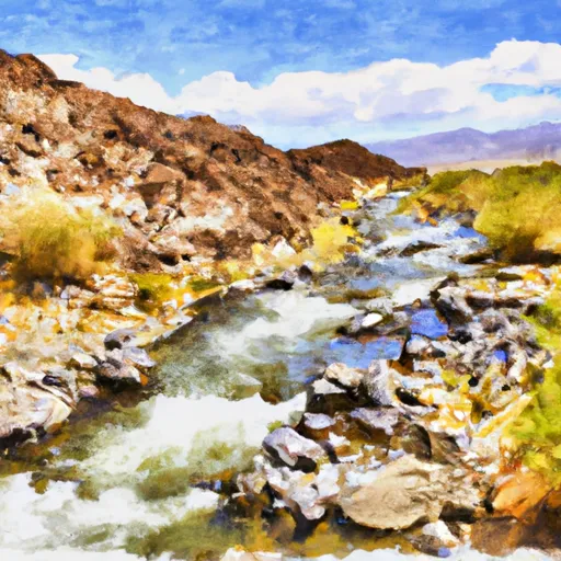
The Whitewater River Run Headwaters, which includes the North Fork and Main Fork to T20N, R66E, Sec 17 in Nevada, is a challenging and exciting adventure for experienced whitewater enthusiasts. The ideal streamflow range (cfs) for this run is between 300 and 800, depending on the time of year and recent rainfall. The class rating for this run is Class III-IV, meaning that it has moderate to difficult rapids with irregular waves and strong currents. The segment mileage for this run is approximately 10 miles.
Some of the specific rapids and obstacles on this run include the Devil's Elbow, which is a tight, rocky drop that requires careful navigation, and the Chute, which is a steep, narrow drop with a large boulder blocking the center of the channel. Other notable rapids include the S-Turn, which is a series of sharp turns through a rocky channel, and the Flume, which is a fast, narrow chute with a steep drop at the bottom.
There are specific regulations that apply to this area, including the requirement for all boaters to wear personal flotation devices (PFDs) at all times. Additionally, camping and fires are only allowed in designated areas, and all trash must be carried out. It is also recommended that boaters have a high level of experience and skill before attempting this run, as the rapids can be unpredictable and challenging.
Overall, the Whitewater River Run Headwaters is a thrilling and challenging experience for experienced whitewater enthusiasts. Boaters should be prepared for a fast-paced, technical run with a variety of obstacles and challenges.
Plan your run down to the hour
Same weather feed Snoflo's iOS app uses -- updated continuously from NOAA / yr.no. Watch the precipitation column on the meteogram; rain ahead of a run typically lifts flows 12-48 hours later depending on the basin.
Next 5 days, hour by hour
Temperature line with weather symbols on top, snow + rain accumulation as columns, humidity as a dotted line.
5-day forecast table
Every 3 hours, broken out across temperature, snow, rain, humidity, and wind. Each cell is colour-coded relative to the column min/max.
| Time | Condition | Temp (°F) | Snow (in) | Rain (in) | Humidity (%) | Wind (mps) | Wind dir |
|---|---|---|---|---|---|---|---|
| Loading detailed forecast… | |||||||
15-day temperature & precipitation
Daily temperatures, snow, and rain projected over the next two weeks -- the upstream story that drives next week's flows.
Regional streamflow levels
USGS streamgauges around Headwaters, Includes N Fork And Main Fork To T20n,R66e, Sec 17 -- useful for spotting upstream pulses and gauging which tributary is contributing what.
| Streamgauge | Discharge | View |
|---|---|---|
| Cleve C Nr Ely | 4 cfs | → |
| Steptoe C Nr Ely | 3 cfs | → |
| Trout Creek Near Callao | 1 cfs | → |
| Granite Creek Near Callao | 0 cfs | → |
| Water Canyon Cr Nr Preston Nv | 1 cfs | → |
| Lehman Creek Near Baker | 4 cfs | → |
Plan a longer trip
The closest boat launches, other paddle runs, and campgrounds so a day on the water can grow into a full weekend.
Other river runs
- Headwaters To Mt Moriah Wilderness Boundary
- Wilderness Boundary To Trailhead/Roads End
- Trailhead To Humboldt-Toiyabe National Forest Boundary
- T15n,R58e,Sec 7 To T15n,R57e,Sec 20
- Headwaters To Eastern Boundary Of Great Basin National Park
Campgrounds
- North Creek Campsite
- Kalamazoo
- East Creek Campground
- Bird Creek Recreation Area
- Timber Creek Campground
- Berry Creek
Points of interest
Whitewater safety
- Check the flow before you run
- Use the linked-gauge card and Regional Flow panel above. Class ratings change with flow -- a Class III at low water can become Class IV+ at high water.
- Know your skill ceiling
- Pick runs comfortably below your ceiling. Cold-water and big-water runs raise the consequences of any mistake.
- Wear the right gear
- Helmet, PFD, drysuit / wetsuit when water is below 60°F. Throw bag, knife, and whistle on your person, not in the boat.
- Scout, set safety, and run with a team
- Scout new rapids on foot, set safety with throw bags above the consequence pool, and run with at least one other competent paddler.
- Respect the river
- Strainers, undercuts, low-head dams, and wood can kill at any class rating. When in doubt, portage.
Set push alerts in the Snoflo app
Save Headwaters, Includes N Fork And Main Fork To T20n,R66e, Sec 17 as a favorite, set a discharge threshold (e.g. "alert me when flow hits 600 cfs"), and the iOS app pushes the moment the linked gauge crosses.
About Headwaters, Includes N Fork And Main Fork To T20n,R66e, Sec 17
What's the optimal flow for Headwaters, Includes N Fork And Main Fork To T20n,R66e, Sec 17?
The optimal flow depends on the section and the craft. Check the Run Details panel for the linked gauge and current status.
How fresh is the cfs reading on this page?
The linked USGS streamgauge reports continuously (every 15 minutes); Snoflo refreshes throughout the day. Hover the streamflow sparkline to read individual datapoints.
What's the whitewater class?
See the Run Details panel for the class rating Snoflo tracks for this run. Class ratings change with flow -- a Class III at low water can become Class IV in high water.
Where do I put in / take out?
Tap Directions in the hero above to open driving directions to the put-in. For shuttle planning, check the Nearby Boat Launches panel and the river run operator's site.
Can I get alerts when flows hit the optimal range?
Yes -- alerts are managed in the Snoflo iOS app. Favorite this run, set a discharge threshold, and you'll get a push the moment the gauge crosses.
Other runs near here
Snoflo-tracked paddle runs within driving distance of Headwaters, Includes N Fork And Main Fork To T20n,R66e, Sec 17.