Headwaters To Mt Jefferson Wilderness Boundary River Run
Community Reviews
Been here? Share the conditions.
Reviews, ratings & photos are added in the free Snoflo iOS app — rate a spot, tag the conditions, and your visit is verified by location. Add or manage your reviews from the app.
Headwaters To Mt Jefferson Wilderness Boundary
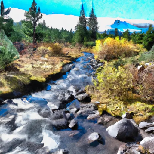
There are several notable rapids and obstacles along the way, including the Narrows, a narrow and technical section of the river that features steep drops and tight turns, as well as the Toilet Bowl, a deep and turbulent pool that can be difficult to navigate. Other notable rapids include House Rock, Boulder Drop, and The Chute.
There are several regulations and guidelines that must be followed when paddling on the Whitewater River. For example, all paddlers must wear a personal flotation device (PFD) at all times while on the river. Additionally, there are restrictions on camping along the river, as well as restrictions on fires and alcohol consumption.
Overall, the Whitewater River Run Headwaters to Mt Jefferson Wilderness Boundary is a challenging and exciting river run that offers beautiful scenery and thrilling rapids. Paddlers should be prepared for a range of water conditions and should follow all regulations and guidelines to ensure a safe and enjoyable experience.
Plan your run down to the hour
Same weather feed Snoflo's iOS app uses -- updated continuously from NOAA / yr.no. Watch the precipitation column on the meteogram; rain ahead of a run typically lifts flows 12-48 hours later depending on the basin.
Next 5 days, hour by hour
Temperature line with weather symbols on top, snow + rain accumulation as columns, humidity as a dotted line.
5-day forecast table
Every 3 hours, broken out across temperature, snow, rain, humidity, and wind. Each cell is colour-coded relative to the column min/max.
| Time | Condition | Temp (°F) | Snow (in) | Rain (in) | Humidity (%) | Wind (mps) | Wind dir |
|---|---|---|---|---|---|---|---|
| Loading detailed forecast… | |||||||
15-day temperature & precipitation
Daily temperatures, snow, and rain projected over the next two weeks -- the upstream story that drives next week's flows.
Regional streamflow levels
USGS streamgauges around Headwaters To Mt Jefferson Wilderness Boundary -- useful for spotting upstream pulses and gauging which tributary is contributing what.
| Streamgauge | Discharge | View |
|---|---|---|
| Mckenzie River At Outlet Of Clear Lake | 157 cfs | → |
| Smith R Ab Smith R Res Nr Belknap Sprgs | 4 cfs | → |
| Blowout Creek Near Detroit | 6 cfs | → |
| Smith River Abv Trail Brdg Resv Nr Belknap Springs | 5 cfs | → |
| Mckenzie River Bl Payne Cr | 167 cfs | → |
| No Santiam R Blw Boulder Crk | 382 cfs | → |
Plan a longer trip
The closest boat launches, other paddle runs, and campgrounds so a day on the water can grow into a full weekend.
Boat launches
- Lost Lake Campground
- Clear Lake
- Big Lake Campground
- Cold Water Cove Campground
- Suttle Lake-Northwest
- Link Creek Boating Site
Other river runs
- Mt. Jefferson Wilderness Boundary To Highway 22
- West Section Line Of Sec 31, T12s, R6e To Middle Santiam Wilderness Boundary
- Headwaters To Confluence With Unnamed Creek West Of Bruler Creek
- Highway 22 To Confluence With Rainbow Creek
- Source To Confluence With Metolius River
Campgrounds
- Big Meadows Horse Camp
- Camp Pioneer (Bsa Cascade Pacific Council)
- Fish Lake Remount Depot - Commissary Cabin
- Fish Lake Remount Depot - Hall House Cabin
- Marion Forks Campground
- Marion Forks Campground And Day Use Area
Whitewater safety
- Check the flow before you run
- Use the linked-gauge card and Regional Flow panel above. Class ratings change with flow -- a Class III at low water can become Class IV+ at high water.
- Know your skill ceiling
- Pick runs comfortably below your ceiling. Cold-water and big-water runs raise the consequences of any mistake.
- Wear the right gear
- Helmet, PFD, drysuit / wetsuit when water is below 60°F. Throw bag, knife, and whistle on your person, not in the boat.
- Scout, set safety, and run with a team
- Scout new rapids on foot, set safety with throw bags above the consequence pool, and run with at least one other competent paddler.
- Respect the river
- Strainers, undercuts, low-head dams, and wood can kill at any class rating. When in doubt, portage.
Set push alerts in the Snoflo app
Save Headwaters To Mt Jefferson Wilderness Boundary as a favorite, set a discharge threshold (e.g. "alert me when flow hits 600 cfs"), and the iOS app pushes the moment the linked gauge crosses.
About Headwaters To Mt Jefferson Wilderness Boundary
What's the optimal flow for Headwaters To Mt Jefferson Wilderness Boundary?
The optimal flow depends on the section and the craft. Check the Run Details panel for the linked gauge and current status.
How fresh is the cfs reading on this page?
The linked USGS streamgauge reports continuously (every 15 minutes); Snoflo refreshes throughout the day. Hover the streamflow sparkline to read individual datapoints.
What's the whitewater class?
See the Run Details panel for the class rating Snoflo tracks for this run. Class ratings change with flow -- a Class III at low water can become Class IV in high water.
Where do I put in / take out?
Tap Directions in the hero above to open driving directions to the put-in. For shuttle planning, check the Nearby Boat Launches panel and the river run operator's site.
Can I get alerts when flows hit the optimal range?
Yes -- alerts are managed in the Snoflo iOS app. Favorite this run, set a discharge threshold, and you'll get a push the moment the gauge crosses.
Other runs near here
Snoflo-tracked paddle runs within driving distance of Headwaters To Mt Jefferson Wilderness Boundary.