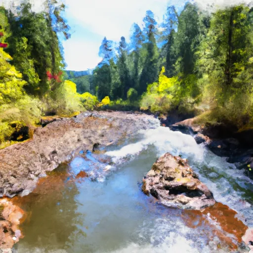
Confluence With Unnamed Creek West Of Bruler To Willamette Nf Boundary River Run
Community Reviews
Been here? Share the conditions.
Reviews, ratings & photos are added in the free Snoflo iOS app — rate a spot, tag the conditions, and your visit is verified by location. Add or manage your reviews from the app.
Confluence With Unnamed Creek West Of Bruler To Willamette Nf Boundary
The segment mileage for this run is approximately 11 miles, with several notable rapids and obstacles along the way. One of the most challenging sections is a rapid known as "The Notch," which requires precise maneuvering through a narrow channel with large boulders and a steep drop. Other rapids include "Soggy Sneakers" and "Terminator," both of which offer exciting challenges for experienced paddlers.
There are specific regulations in place for this area, including a permit requirement for commercial outfitters and a ban on motorized watercraft. It is also important to practice Leave No Trace principles and respect the natural environment while enjoying this beautiful stretch of river.
Multiple sources confirm these details about the Whitewater River run Confluence With Unnamed Creek West Of Bruler To Willamette Nf Boundary, including the American Whitewater website and local guidebooks. Overall, this run offers a thrilling and scenic whitewater experience for those with the necessary skills and equipment.
Plan your run down to the hour
Same weather feed Snoflo's iOS app uses -- updated continuously from NOAA / yr.no. Watch the precipitation column on the meteogram; rain ahead of a run typically lifts flows 12-48 hours later depending on the basin.
Next 5 days, hour by hour
Temperature line with weather symbols on top, snow + rain accumulation as columns, humidity as a dotted line.
5-day forecast table
Every 3 hours, broken out across temperature, snow, rain, humidity, and wind. Each cell is colour-coded relative to the column min/max.
| Time | Condition | Temp (°F) | Snow (in) | Rain (in) | Humidity (%) | Wind (mps) | Wind dir |
|---|---|---|---|---|---|---|---|
| Loading detailed forecast… | |||||||
15-day temperature & precipitation
Daily temperatures, snow, and rain projected over the next two weeks -- the upstream story that drives next week's flows.
Regional streamflow levels
USGS streamgauges around Confluence With Unnamed Creek West Of Bruler To Willamette Nf Boundary -- useful for spotting upstream pulses and gauging which tributary is contributing what.
| Streamgauge | Discharge | View |
|---|---|---|
| Quartzville Creek Near Cascadia | 21 cfs | → |
| Schafer Creek Near Lacomb | 0 cfs | → |
| Blowout Creek Near Detroit | 6 cfs | → |
| North Santiam River At Niagara | 999 cfs | → |
| No Santiam R Blw Boulder Crk | 382 cfs | → |
| South Santiam River Below Cascadia | 61 cfs | → |
Plan a longer trip
The closest boat launches, other paddle runs, and campgrounds so a day on the water can grow into a full weekend.
Boat launches
Other river runs
- Middle Santiam Wilderness Boundary To Willamette Nf Boundary
- Middle Santiam River
- Headwaters To Confluence With Unnamed Creek West Of Bruler Creek
- West Section Line Of Sec 31, T12s, R6e To Middle Santiam Wilderness Boundary
- North Santiam River
Campgrounds
- Old Miners Meadow Group Use Area
- Yellowbottom Recreation Site
- Yellowbottom
- Santiam Horse Camp
- Whitcomb Creek
- Boat In Camping
Whitewater safety
- Check the flow before you run
- Use the linked-gauge card and Regional Flow panel above. Class ratings change with flow -- a Class III at low water can become Class IV+ at high water.
- Know your skill ceiling
- Pick runs comfortably below your ceiling. Cold-water and big-water runs raise the consequences of any mistake.
- Wear the right gear
- Helmet, PFD, drysuit / wetsuit when water is below 60°F. Throw bag, knife, and whistle on your person, not in the boat.
- Scout, set safety, and run with a team
- Scout new rapids on foot, set safety with throw bags above the consequence pool, and run with at least one other competent paddler.
- Respect the river
- Strainers, undercuts, low-head dams, and wood can kill at any class rating. When in doubt, portage.
Set push alerts in the Snoflo app
Save Confluence With Unnamed Creek West Of Bruler To Willamette Nf Boundary as a favorite, set a discharge threshold (e.g. "alert me when flow hits 600 cfs"), and the iOS app pushes the moment the linked gauge crosses.
About Confluence With Unnamed Creek West Of Bruler To Willamette Nf Boundary
What's the optimal flow for Confluence With Unnamed Creek West Of Bruler To Willamette Nf Boundary?
The optimal flow depends on the section and the craft. Check the Run Details panel for the linked gauge and current status.
How fresh is the cfs reading on this page?
The linked USGS streamgauge reports continuously (every 15 minutes); Snoflo refreshes throughout the day. Hover the streamflow sparkline to read individual datapoints.
What's the whitewater class?
See the Run Details panel for the class rating Snoflo tracks for this run. Class ratings change with flow -- a Class III at low water can become Class IV in high water.
Where do I put in / take out?
Tap Directions in the hero above to open driving directions to the put-in. For shuttle planning, check the Nearby Boat Launches panel and the river run operator's site.
Can I get alerts when flows hit the optimal range?
Yes -- alerts are managed in the Snoflo iOS app. Favorite this run, set a discharge threshold, and you'll get a push the moment the gauge crosses.
Other runs near here
Snoflo-tracked paddle runs within driving distance of Confluence With Unnamed Creek West Of Bruler To Willamette Nf Boundary.