Upper Green River River Run
Community Reviews
Been here? Share the conditions.
Reviews, ratings & photos are added in the free Snoflo iOS app — rate a spot, tag the conditions, and your visit is verified by location. Add or manage your reviews from the app.
Upper Green River
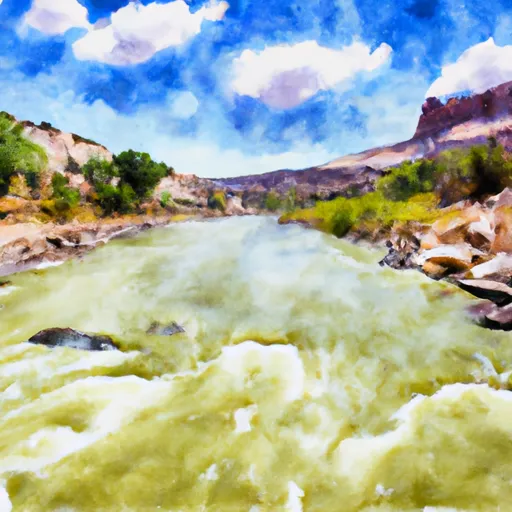
The segment mileage of the Upper Green River is approximately 13 miles, starting at Flaming Gorge Dam and ending at Little Hole. The river features several notable rapids, including the Swallow Canyon Rapid, Hell Hole Rapid, and S.O.B. Rapid. These rapids range from Class III to IV in difficulty and require technical skill and experience to navigate safely.
In addition to the rapids, the Upper Green River is also known for its stunning scenery, including towering red rock cliffs and lush vegetation. However, it is important to note that the area is protected as part of the Flaming Gorge National Recreation Area, and there are specific regulations in place to ensure the preservation of the natural environment. Visitors are required to obtain a permit for the use of the river and must follow all leave-no-trace principles to minimize their impact on the area.
Overall, the Upper Green River is a challenging and rewarding whitewater river run that offers both thrilling rapids and breathtaking scenery. However, it is important to approach this river with caution and respect for the environment to ensure a safe and responsible experience.
Plan your run down to the hour
Same weather feed Snoflo's iOS app uses -- updated continuously from NOAA / yr.no. Watch the precipitation column on the meteogram; rain ahead of a run typically lifts flows 12-48 hours later depending on the basin.
Next 5 days, hour by hour
Temperature line with weather symbols on top, snow + rain accumulation as columns, humidity as a dotted line.
5-day forecast table
Every 3 hours, broken out across temperature, snow, rain, humidity, and wind. Each cell is colour-coded relative to the column min/max.
| Time | Condition | Temp (°F) | Snow (in) | Rain (in) | Humidity (%) | Wind (mps) | Wind dir |
|---|---|---|---|---|---|---|---|
| Loading detailed forecast… | |||||||
15-day temperature & precipitation
Daily temperatures, snow, and rain projected over the next two weeks -- the upstream story that drives next week's flows.
Regional streamflow levels
USGS streamgauges around Upper Green River -- useful for spotting upstream pulses and gauging which tributary is contributing what.
| Streamgauge | Discharge | View |
|---|---|---|
| Green River Near Greendale | 1,730 cfs | → |
| Henrys Fork Near Manila | 8 cfs | → |
| Big Brush Creek Abv Red Fleet Res | 9 cfs | → |
| Ashley Cr Abv Sp Nr Vernal Ut | 4 cfs | → |
| Ashley Creek Near Vernal | 62 cfs | → |
| Green River Near Jensen | 2,190 cfs | → |
Plan a longer trip
The closest boat launches, other paddle runs, and campgrounds so a day on the water can grow into a full weekend.
Boat launches
- Little Hole Trail Daggett County
- Little Hole Boat Launch Area
- Browns Park Road Daggett County
- Spillway Boat Launch Area
- Cedar Springs Boating Ramp
- Dutch John Marina
Campgrounds
- Green River Camps
- Little Hole South Campsite
- Grasshopper I Campsite
- Grasshopper Ii Campsite
- Jackson Creek Campsite
- Dripping Springs - Flaming Gorge
Fishing spots
- Green River Below Flaming Gorge Dam
- Cart Creek
- West Greens Lake Fishing Site
- Crouse Reservoir
- Flaming Gorge Reservoir
- Red Fleet Reservoir
Whitewater safety
- Check the flow before you run
- Use the linked-gauge card and Regional Flow panel above. Class ratings change with flow -- a Class III at low water can become Class IV+ at high water.
- Know your skill ceiling
- Pick runs comfortably below your ceiling. Cold-water and big-water runs raise the consequences of any mistake.
- Wear the right gear
- Helmet, PFD, drysuit / wetsuit when water is below 60°F. Throw bag, knife, and whistle on your person, not in the boat.
- Scout, set safety, and run with a team
- Scout new rapids on foot, set safety with throw bags above the consequence pool, and run with at least one other competent paddler.
- Respect the river
- Strainers, undercuts, low-head dams, and wood can kill at any class rating. When in doubt, portage.
Set push alerts in the Snoflo app
Save Upper Green River as a favorite, set a discharge threshold (e.g. "alert me when flow hits 600 cfs"), and the iOS app pushes the moment the linked gauge crosses.
About Upper Green River
What's the optimal flow for Upper Green River?
The optimal flow depends on the section and the craft. Check the Run Details panel for the linked gauge and current status.
How fresh is the cfs reading on this page?
The linked USGS streamgauge reports continuously (every 15 minutes); Snoflo refreshes throughout the day. Hover the streamflow sparkline to read individual datapoints.
What's the whitewater class?
See the Run Details panel for the class rating Snoflo tracks for this run. Class ratings change with flow -- a Class III at low water can become Class IV in high water.
Where do I put in / take out?
Tap Directions in the hero above to open driving directions to the put-in. For shuttle planning, check the Nearby Boat Launches panel and the river run operator's site.
Can I get alerts when flows hit the optimal range?
Yes -- alerts are managed in the Snoflo iOS app. Favorite this run, set a discharge threshold, and you'll get a push the moment the gauge crosses.
Other runs near here
Snoflo-tracked paddle runs within driving distance of Upper Green River.