Granite Creek, Dolores River Segment 2 river run
Granite Creek, Dolores River Segment 2
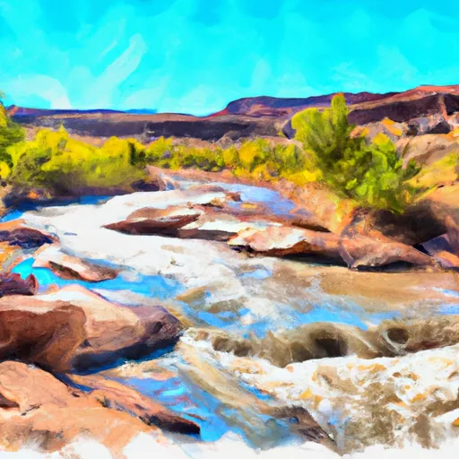
The Granite Creek segment on the Dolores River in Utah is a popular whitewater river run for kayaking and rafting enthusiasts. The ideal streamflow range for this section is between 300-1,500 cfs, with the best times to go being in May and June. The segment's class rating ranges from III-IV and covers 16 miles from the confluence with the West Fork of the Dolores River to the Slickrock takeout.
The granite canyon rapids and the boulder gardens are the most challenging obstacles found on this segment. The first rapid, "the Narrows," is a technical class IV rapid with a narrow chute and steep drops. The "Boulder Gardens" is another class IV rapid with large boulders to navigate around. Other notable rapids include the "Upper Granite," "Lower Granite," and "Little Niagara."
There are no specific regulations to this area; however, the Bureau of Land Management recommends wearing a lifejacket at all times while on the river. Additionally, it is recommended that all boaters have prior experience with class III-IV rapids before attempting this segment.
In conclusion, the Granite Creek segment on the Dolores River in Utah, with its ideal streamflow range, class rating, and challenging rapids, is a great location for experienced kayakers and rafters. While no specific regulations are in place, it is essential to follow safety guidelines and have experience with class III-IV rapids before attempting this segment.
Plan your run down to the hour
Same weather feed Snoflo's iOS app uses -- updated continuously from NOAA / yr.no. Watch the precipitation column on the meteogram; rain ahead of a run typically lifts flows 12-48 hours later depending on the basin.
Next 5 days, hour by hour
Temperature line with weather symbols on top, snow + rain accumulation as columns, humidity as a dotted line.
5-day forecast table
Every 3 hours, broken out across temperature, snow, rain, humidity, and wind. Each cell is colour-coded relative to the column min/max.
| Time | Condition | Temp (°F) | Snow (in) | Rain (in) | Humidity (%) | Wind (mps) | Wind dir |
|---|---|---|---|---|---|---|---|
| Loading detailed forecast… | |||||||
15-day temperature & precipitation
Daily temperatures, snow, and rain projected over the next two weeks -- the upstream story that drives next week's flows.
Regional streamflow levels
USGS streamgauges around Granite Creek, Dolores River Segment 2 -- useful for spotting upstream pulses and gauging which tributary is contributing what.
| Streamgauge | Discharge | View |
|---|---|---|
| Dolores River Near Cisco | 103 cfs | → |
| Colorado River Near Cisco | 2,900 cfs | → |
| Dolores River Near Gateway | 132 cfs | → |
| Castle Creek Below Castle Valley Near Moab | 4 cfs | → |
| Colorado River Near Colorado-Utah State Line | 2,820 cfs | → |
| Mill Creek Below Sheley Tunnel | 3 cfs | → |
Plan a longer trip
The closest boat launches, other paddle runs, and campgrounds so a day on the water can grow into a full weekend.
Boat launches
- Grand County
- Dewey Bridge Recreation Site
- Hittle Bottom Recreation Site
- Ut 128 Moab
- Lower Onion Creek Boat Ramp
- Fisher Towers Road Grand County
Other river runs
- Dolores River Segment 2
- Dolores River Segment 1
- Fisher Creek, Dolores River Segment 1
- Fisher Creek
- Beaver Creek
Campgrounds
- Cowskin Camping Area
- Dewey Bridge Campground
- Dewey Bridge
- Dewey Bridge Recreation Site
- Hittle Bottom Recreation Site
- Fisher Towers Recreation Site
Fishing spots
Whitewater safety
- Check the flow before you run
- Use the linked-gauge card and Regional Flow panel above. Class ratings change with flow -- a Class III at low water can become Class IV+ at high water.
- Know your skill ceiling
- Pick runs comfortably below your ceiling. Cold-water and big-water runs raise the consequences of any mistake.
- Wear the right gear
- Helmet, PFD, drysuit / wetsuit when water is below 60°F. Throw bag, knife, and whistle on your person, not in the boat.
- Scout, set safety, and run with a team
- Scout new rapids on foot, set safety with throw bags above the consequence pool, and run with at least one other competent paddler.
- Respect the river
- Strainers, undercuts, low-head dams, and wood can kill at any class rating. When in doubt, portage.
Set push alerts in the Snoflo app
Save Granite Creek, Dolores River Segment 2 as a favorite, set a discharge threshold (e.g. "alert me when flow hits 600 cfs"), and the iOS app pushes the moment the linked gauge crosses.
About Granite Creek, Dolores River Segment 2
What's the optimal flow for Granite Creek, Dolores River Segment 2?
The optimal flow depends on the section and the craft. Check the Run Details panel for the linked gauge and current status.
How fresh is the cfs reading on this page?
The linked USGS streamgauge reports continuously (every 15 minutes); Snoflo refreshes throughout the day. Hover the streamflow sparkline to read individual datapoints.
What's the whitewater class?
See the Run Details panel for the class rating Snoflo tracks for this run. Class ratings change with flow -- a Class III at low water can become Class IV in high water.
Where do I put in / take out?
Tap Directions in the hero above to open driving directions to the put-in. For shuttle planning, check the Nearby Boat Launches panel and the river run operator's site.
Can I get alerts when flows hit the optimal range?
Yes -- alerts are managed in the Snoflo iOS app. Favorite this run, set a discharge threshold, and you'll get a push the moment the gauge crosses.
Other runs near here
Snoflo-tracked paddle runs within driving distance of Granite Creek, Dolores River Segment 2.