The Headwaters In The Gallatin Range To Ends Where The River Parallels A Two-Lane Highway River Run
Community Reviews
Been here? Share the conditions.
Reviews, ratings & photos are added in the free Snoflo iOS app — rate a spot, tag the conditions, and your visit is verified by location. Add or manage your reviews from the app.
The Headwaters In The Gallatin Range To Ends Where The River Parallels A Two-Lane Highway
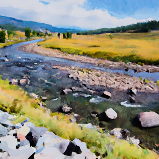
The Whitewater River Run features several exciting rapids and obstacles, including The Kitchen Sink, a Class IV rapid with powerful waves and a tight chute. Other notable rapids include Box Elder, Zig Zag, and Big Kahuna. The river also features several boulder gardens and tight channels that require precise navigation.
The area is regulated by the Bureau of Land Management and requires a permit to use. It is important to note that the Whitewater River Run is not suitable for beginners. Rafters must have previous experience and be in good physical condition. Additionally, all rafters must wear a personal flotation device and a helmet.
In conclusion, the Whitewater River Run in Wyoming is an exciting adventure for experienced rafters. With its ideal streamflow range, Class III-IV rating, and challenging rapids, this run offers a thrilling experience for those seeking an adrenaline rush. However, it is important to follow regulations and safety guidelines to ensure a safe and enjoyable trip.
Plan your run down to the hour
Same weather feed Snoflo's iOS app uses -- updated continuously from NOAA / yr.no. Watch the precipitation column on the meteogram; rain ahead of a run typically lifts flows 12-48 hours later depending on the basin.
Next 5 days, hour by hour
Temperature line with weather symbols on top, snow + rain accumulation as columns, humidity as a dotted line.
5-day forecast table
Every 3 hours, broken out across temperature, snow, rain, humidity, and wind. Each cell is colour-coded relative to the column min/max.
| Time | Condition | Temp (°F) | Snow (in) | Rain (in) | Humidity (%) | Wind (mps) | Wind dir |
|---|---|---|---|---|---|---|---|
| Loading detailed forecast… | |||||||
15-day temperature & precipitation
Daily temperatures, snow, and rain projected over the next two weeks -- the upstream story that drives next week's flows.
Regional streamflow levels
USGS streamgauges around The Headwaters In The Gallatin Range To Ends Where The River Parallels A Two-Lane Highway -- useful for spotting upstream pulses and gauging which tributary is contributing what.
| Streamgauge | Discharge | View |
|---|---|---|
| Tantalus Creek At Norris Junction | 3 cfs | → |
| Boiling River At Mammoth | 22 cfs | → |
| Gardner River Near Mammoth Ynp | 157 cfs | → |
| Gibbon River At Madison Jct | 94 cfs | → |
| Firehole River Near West Yellowstone Mt | 211 cfs | → |
| Madison River Near West Yellowstone Mt | 315 cfs | → |
Plan a longer trip
The closest boat launches, other paddle runs, and campgrounds so a day on the water can grow into a full weekend.
Other river runs
- The Headwaters, In The Gallatin Range To Ends Downstream Of Osprey Falls
- Begins Where The River Parallels A Two-Lane Highway To The Western Boundary Of Yellowstone National Park
- Begins Downstream Of Osprey Falls To Confluence With Yellowstone River, At The Northern Park Boundary
- The Junction Of The Firehole And Gibbon Rivers To The Western Yellowstone National Park Boundary
- Gardiner Town Run
Campgrounds
Fishing spots
Whitewater safety
- Check the flow before you run
- Use the linked-gauge card and Regional Flow panel above. Class ratings change with flow -- a Class III at low water can become Class IV+ at high water.
- Know your skill ceiling
- Pick runs comfortably below your ceiling. Cold-water and big-water runs raise the consequences of any mistake.
- Wear the right gear
- Helmet, PFD, drysuit / wetsuit when water is below 60°F. Throw bag, knife, and whistle on your person, not in the boat.
- Scout, set safety, and run with a team
- Scout new rapids on foot, set safety with throw bags above the consequence pool, and run with at least one other competent paddler.
- Respect the river
- Strainers, undercuts, low-head dams, and wood can kill at any class rating. When in doubt, portage.
Set push alerts in the Snoflo app
Save The Headwaters In The Gallatin Range To Ends Where The River Parallels A Two-Lane Highway as a favorite, set a discharge threshold (e.g. "alert me when flow hits 600 cfs"), and the iOS app pushes the moment the linked gauge crosses.
About The Headwaters In The Gallatin Range To Ends Where The River Parallels A Two-Lane Highway
What's the optimal flow for The Headwaters In The Gallatin Range To Ends Where The River Parallels A Two-Lane Highway?
The optimal flow depends on the section and the craft. Check the Run Details panel for the linked gauge and current status.
How fresh is the cfs reading on this page?
The linked USGS streamgauge reports continuously (every 15 minutes); Snoflo refreshes throughout the day. Hover the streamflow sparkline to read individual datapoints.
What's the whitewater class?
See the Run Details panel for the class rating Snoflo tracks for this run. Class ratings change with flow -- a Class III at low water can become Class IV in high water.
Where do I put in / take out?
Tap Directions in the hero above to open driving directions to the put-in. For shuttle planning, check the Nearby Boat Launches panel and the river run operator's site.
Can I get alerts when flows hit the optimal range?
Yes -- alerts are managed in the Snoflo iOS app. Favorite this run, set a discharge threshold, and you'll get a push the moment the gauge crosses.
Other runs near here
Snoflo-tracked paddle runs within driving distance of The Headwaters In The Gallatin Range To Ends Where The River Parallels A Two-Lane Highway.