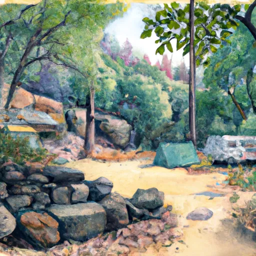
Atwell Mill Campground
Community Reviews
Been here? Share the conditions.
Reviews, ratings & photos are added in the free Snoflo iOS app — rate a spot, tag the conditions, and your visit is verified by location. Add or manage your reviews from the app.
Atwell Mill
Reservations are not accepted at Atwell Mill camping area; campsites are available on a first-come, first-served basis. It is advisable to arrive early in the day, especially during peak season, to secure a camping spot. The best time of year to visit is during the summer months when the weather is pleasant and the trails are accessible. However, it is important to be cautious of the potential for thunderstorms and wildfires in the area, especially during the dry season. Campers should stay informed about any fire restrictions or closures that may be in place.
Overall, Atwell Mill camping area offers a serene and picturesque setting for campers to immerse themselves in nature. With its amenities, hiking opportunities, and stunning surroundings, it is a great choice for anyone seeking an outdoor adventure in California's Sequoia National Forest.
What's on-site at Atwell Mill
Key facilities Snoflo tracks for this campground. Confirm with the operator before booking -- amenities can change seasonally.
Plan your trip down to the hour
Same weather feed Snoflo's iOS app uses -- updated continuously from NOAA / yr.no.
Next 5 days, hour by hour
Temperature line with weather symbols on top, snow + rain accumulation as columns, humidity as a dotted line.
5-day forecast table
Every 3 hours, broken out across temperature, snow, rain, humidity, and wind. Each cell is colour-coded relative to the column min/max so trends jump out at a glance.
| Time | Condition | Temp (°F) | Snow (in) | Rain (in) | Humidity (%) | Wind (mps) | Wind dir |
|---|---|---|---|---|---|---|---|
| Loading detailed forecast… | |||||||
15-day temperature & precipitation
Daily temperatures, snow, and rain projected over the next two weeks. Hover any point for the full breakdown.
Other campgrounds in the area
Snoflo-tracked campsites within driving distance of Atwell Mill, with reservations status.
| Campground | Reservations | Toilets | View |
|---|---|---|---|
| Atwell Mill - Sequoia National Park | ✗ | ✓ | → |
| Cold Springs - Sequoia National Park | ✗ | ✓ | → |
| Buckeye Flat - Sequoia National Park | ✓ | ✓ | → |
| Buckeye Flat | ✗ | ✗ | → |
| Bearpaw Meadow High Sierra Camp | ✗ | ✗ | → |
Nearby streamflow
USGS streamgauges within reach of Atwell Mill -- pulled live from the National Water Information System.
| Streamgauge | Discharge | View |
|---|---|---|
| Marble Fork Kaweah R Ab Horse C Nr Lodgepole Ca | 1 cfs | → |
| Sf Tule R Nr Cholollo Campground Nr Porterville Ca | 8 cfs | → |
| Sf Tule R Nr Reservation Bndry Nr Porterville Ca | 10 cfs | → |
| Deer C Nr Fountain Springs Ca | 5 cfs | → |
| Sf Kern R Nr Onyx Ca | 21 cfs | → |
Nearby snow depths
NRCS SNOTEL stations within reach of Atwell Mill -- relevant when planning a shoulder-season or alpine trip.
| SNOTEL station | Snowpack | 24h Snowfall | View |
|---|---|---|---|
| Charlotte Lake | 11.3 in | 0.0 in | → |
| Cottonwood Lakes | 0.0 in | 0.0 in | → |
| Nohrsc Casa Vieja Meadows | 169.8 in | 0.0 in | → |
| Beach Meadows | 0.0 in | 0.0 in | → |
| Blackcap Basin Goes | 0.0 in | 0.0 in | → |
Plan a longer trip
The closest parks, lakes, boat launches, and paddle runs so a camping night can grow into a full weekend.
Parks
- John Krebs Wilderness (Draft Boundary)
- Kings Canyon National Park - Big Stump Entrance
- Sequoia National Park
- Mountain Home Demonstration State Forest
- Wilderness Jennie Lakes
- Wilderness Sequoia-Kings Canyon
Fishing spots
- Jennie Lake
- Balch Park Lakes, Eastern Lake
- Balch Park Lakes, Western Lake
- Kaweah Lake
- Weaver Lake
- Lake Kaweah
Points of interest
Paddle runs
- Atwell Mill Trail Bridge At ~5,800 Ft (Boundary Extends 0.25 Mile On Each Side Of The River.) To Boundary Of Sequoia & Kings Canyon National Park
- 8,000 Ft Contour Line (Boundary Extend 0.25 Mile On Each Side Of River) To The Atwell Mill Trail Bridge At ~ 5,800 Ft
- 9,000 Ft Contour Line (Boundary Extend 0.25 Mile On Each Side Of River) To 8,000 Ft Contour Line
- Wilderness Boundary (Boundary Extend 0.25 Mile On Each Side Of River) To Boundary Of Sequoia & Kings Canyon National Park
- Confluence Of Lone Pine And Hamilton (Deer) Creeks (Boundary Extend 0.25 Mile On Each Side Of River) To Wildernes Boundary
- Outlet Of Green Meadows North Of The Windy Gap And Windy Ridges (Boundary Extend 0.25 Mile On Each Side Of River) To Bridge Above South Fork Campground
Camping essentials & Leave No Trace
- Pack it in, pack it out
- Take all trash, food scraps, and gear back with you to keep campsites clean and protect wildlife.
- Respect wildlife
- Observe animals from a distance, store food securely, and never feed wildlife to maintain natural behavior and safety.
- Know before you go
- Check weather, fire restrictions, trail conditions, and permit requirements to ensure a safe and well-planned trip.
- Minimize campfire impact
- Use established fire rings, keep fires small, fully extinguish them, or opt for a camp stove when fires are restricted.
- Leave what you find
- Preserve natural and cultural features by avoiding removal of plants, rocks, artifacts, or other elements of the environment.
Set push alerts in the Snoflo app
Save Atwell Mill as a favorite, set a custom threshold (precipitation, snowpack, freezing temperatures), and the iOS app will push the moment conditions cross.
About Atwell Mill
Can I make reservations at Atwell Mill?
This campground does not appear to accept reservations -- it's typically first-come, first-served. Arrive early on summer weekends.
How fresh is the weather data on this page?
The hourly forecast updates throughout the day from the NOAA / yr.no public feeds. Streamflow data is pulled live from USGS streamgauges and snowpack from the NRCS SNOTEL network.
What's the best time of year to visit?
Use the 15-day temperature & precipitation outlook on this page to plan -- pick a window with comfortable temperatures and low precipitation. For longer trips, the 5-day hourly meteogram shows snow + rain accumulation hour-by-hour.
How do I get to Atwell Mill?
Tap Directions in the hero above to open driving directions in Google Maps, or Open in map to center the Snoflo interactive map on the campground.
Can I get alerts when conditions change?
Yes -- alerts are managed through the Snoflo iOS app. Favorite this campground, set a threshold (temperature, snowpack, precipitation), and you'll get a push the moment it crosses.
Other campgrounds near here
Snoflo-tracked campgrounds within driving distance of Atwell Mill.