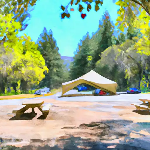
New Shady Rest Campground
Community Reviews
Been here? Share the conditions.
Reviews, ratings & photos are added in the free Snoflo iOS app — rate a spot, tag the conditions, and your visit is verified by location. Add or manage your reviews from the app.
New Shady Rest
Reservation policies for the New Shady Rest camping area vary depending on the time of year. During peak season (usually from late spring to early fall), reservations can be made in advance to secure a spot. However, during the off-peak season, the campground operates on a first-come, first-served basis. Therefore, it is recommended to plan accordingly and arrive early to secure a campsite during busy periods.
The best time to visit the New Shady Rest camping area is generally during the summer months when the weather is pleasant and suitable for outdoor activities. However, it is important to note that the campground is situated at an elevation of approximately 7,000 feet, so temperatures can drop significantly during the evenings. Therefore, campers should be prepared with appropriate clothing and gear for cooler temperatures.
The New Shady Rest camping area is surrounded by beautiful scenery and offers easy access to hiking and biking trails, making it a popular destination for outdoor enthusiasts. However, campers should be cautious of wildlife in the area, particularly bears. It is essential to properly store food and dispose of waste in designated bear-proof containers to avoid attracting these animals. Adhering to these precautions will help ensure a safe and enjoyable camping experience at New Shady Rest.
What's on-site at New Shady Rest
Key facilities Snoflo tracks for this campground. Confirm with the operator before booking -- amenities can change seasonally.
Plan your trip down to the hour
Same weather feed Snoflo's iOS app uses -- updated continuously from NOAA / yr.no.
Next 5 days, hour by hour
Temperature line with weather symbols on top, snow + rain accumulation as columns, humidity as a dotted line.
5-day forecast table
Every 3 hours, broken out across temperature, snow, rain, humidity, and wind. Each cell is colour-coded relative to the column min/max so trends jump out at a glance.
| Time | Condition | Temp (°F) | Snow (in) | Rain (in) | Humidity (%) | Wind (mps) | Wind dir |
|---|---|---|---|---|---|---|---|
| Loading detailed forecast… | |||||||
15-day temperature & precipitation
Daily temperatures, snow, and rain projected over the next two weeks. Hover any point for the full breakdown.
Other campgrounds in the area
Snoflo-tracked campsites within driving distance of New Shady Rest, with reservations status.
| Campground | Reservations | Toilets | View |
|---|---|---|---|
| Old Shady Rest Campground | ✓ | ✗ | → |
| Pine Glen Group Campground | ✓ | ✗ | → |
| New Shady Rest Campground | ✓ | ✗ | → |
| Old Shady Rest | ✓ | ✓ | → |
| Pine Glen - Mammoth Lakes | ✓ | ✓ | → |
Nearby streamflow
USGS streamgauges within reach of New Shady Rest -- pulled live from the National Water Information System.
| Streamgauge | Discharge | View |
|---|---|---|
| Mf San Joaquin R Nr Mammoth Lakes Ca | 64 cfs | → |
| Deadman C A Big Springs Nr Crestview Ca | 20 cfs | → |
| Hot C A Flume Nr Mammoth Lakes Ca | 43 cfs | → |
| Merced R A Happy Isles Bridge Nr Yosemite Ca | 97 cfs | → |
| Nf Willow C Nr Sugar Pine Ca | 416 cfs | → |
| Big C Div Nr Fish Camp Ca | 0 cfs | → |
Nearby snow depths
NRCS SNOTEL stations within reach of New Shady Rest -- relevant when planning a shoulder-season or alpine trip.
| SNOTEL station | Snowpack | 24h Snowfall | View |
|---|---|---|---|
| Crrel-Ucsb Energy Site | 31.5 in | 0.0 in | → |
| Nohrsc Mammoth Pass | 216.7 in | 0.0 in | → |
| Agnew Pass (Goes) | 5.2 in | 0.4 in | → |
| Mammoth Lakes 16.3 Ese | 1.0 in | 0.3 in | → |
| Nohrsc Green Mtn | 7.4 in | 0.0 in | → |
| Nohrsc Rock Creek | 0.6 in | 0.0 in | → |
Plan a longer trip
The closest parks, lakes, boat launches, and paddle runs so a camping night can grow into a full weekend.
Parks
- Trails End Park
- Mammoth Creek Community Park
- Owens River Headwaters Wilderness
- Devils Postpile National Monument
- Mono Lake Tufa State Reserve
- Granite Mountain Wilderness
Boat launches
- Lake Mary
- Lake George
- Convict Lake Resort
- Gull Lake Marina
- Gull Meadows Car Top Boat Launch
- Big Rock Resort And Marina
Fishing spots
Points of interest
- Mammoth Lakes Welcome Center
- Mammoth Museum
- Minaret Vista Observation Site
- Visitor Contact / Ranger Station
- Devils Postpile Formation
- Hot Creek Geologic Site
Paddle runs
- Wilderness Boundary To La Dept. Of Water And Power Property
- Fish Hatchery To Nf Boundary
- Confluence With Glass Creek To Big Springs
- Agnew Meadows To Soda Springs Footbridge
- National Monument Boundary To Soda Springs Footbridge In Devils Postpile National Monument
- Soda Springs Footbridge In Devils Postpile National Monument To Rainbow Falls
Camping essentials & Leave No Trace
- Pack it in, pack it out
- Take all trash, food scraps, and gear back with you to keep campsites clean and protect wildlife.
- Respect wildlife
- Observe animals from a distance, store food securely, and never feed wildlife to maintain natural behavior and safety.
- Know before you go
- Check weather, fire restrictions, trail conditions, and permit requirements to ensure a safe and well-planned trip.
- Minimize campfire impact
- Use established fire rings, keep fires small, fully extinguish them, or opt for a camp stove when fires are restricted.
- Leave what you find
- Preserve natural and cultural features by avoiding removal of plants, rocks, artifacts, or other elements of the environment.
Set push alerts in the Snoflo app
Save New Shady Rest as a favorite, set a custom threshold (precipitation, snowpack, freezing temperatures), and the iOS app will push the moment conditions cross.
About New Shady Rest
Can I make reservations at New Shady Rest?
Yes -- this campground accepts reservations. Snoflo recommends booking early for peak season; check the operator (Recreation.gov / state park system / private operator) for the booking window and cancellation policy.
How fresh is the weather data on this page?
The hourly forecast updates throughout the day from the NOAA / yr.no public feeds. Streamflow data is pulled live from USGS streamgauges and snowpack from the NRCS SNOTEL network.
What's the best time of year to visit?
Use the 15-day temperature & precipitation outlook on this page to plan -- pick a window with comfortable temperatures and low precipitation. For longer trips, the 5-day hourly meteogram shows snow + rain accumulation hour-by-hour.
How do I get to New Shady Rest?
Tap Directions in the hero above to open driving directions in Google Maps, or Open in map to center the Snoflo interactive map on the campground.
Can I get alerts when conditions change?
Yes -- alerts are managed through the Snoflo iOS app. Favorite this campground, set a threshold (temperature, snowpack, precipitation), and you'll get a push the moment it crosses.
Other campgrounds near here
Snoflo-tracked campgrounds within driving distance of New Shady Rest.