Lake Fork Arm Boat-In Campsite campground
Community Reviews
Been here? Share the conditions.
Reviews, ratings & photos are added in the free Snoflo iOS app — rate a spot, tag the conditions, and your visit is verified by location. Add or manage your reviews from the app.
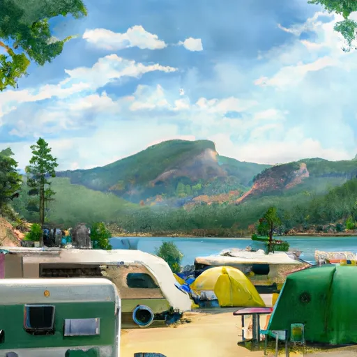
Lake Fork Arm Boat-In Campsite
Nearby points of interest include the nearby Weminuche Wilderness, which offers over 500 miles of hiking trails, and the Rio Grande National Forest, which is home to numerous wildlife species and offers excellent fishing opportunities. Additionally, the historic town of Creede is just a short drive away and features a variety of shops, restaurants, and cultural attractions.
The campground amenities include primitive camping sites with fire rings and picnic tables, as well as vault toilets and trash disposal. The area is also equipped with bear-proof food storage lockers to ensure the safety of campers and wildlife.
Interesting facts about the area include that it is home to the Colorado State Fish, the Greenback Cutthroat Trout, and that the San Juan Mountains are the largest mountain range in Colorado.
The best time of year to visit Lake Fork Arm Boat-In Campsite is from June through September when temperatures range from the mid-60s to mid-70s Fahrenheit during the day and drop to the low 40s at night. It is important to note that the campsite is only accessible by boat, so visitors must bring their own watercraft or rent one from a nearby outfitter.
Sources:
- https://www.fs.usda.gov/recarea/sanjuan/recarea/?recid=43285
- https://www.outtherecolorado.com/camping-lake-fork-arm-san-juan-national-forest/
- https://www.colorado.com/articles/creede-colorado-perfect-spot-disconnect-and-reconnect-nature
What's on-site at Lake Fork Arm Boat-In Campsite
Key facilities Snoflo tracks for this campground. Confirm with the operator before booking -- amenities can change seasonally.
Plan your trip down to the hour
Same weather feed Snoflo's iOS app uses -- updated continuously from NOAA / yr.no.
Next 5 days, hour by hour
Temperature line with weather symbols on top, snow + rain accumulation as columns, humidity as a dotted line.
5-day forecast table
Every 3 hours, broken out across temperature, snow, rain, humidity, and wind. Each cell is colour-coded relative to the column min/max so trends jump out at a glance.
| Time | Condition | Temp (°F) | Snow (in) | Rain (in) | Humidity (%) | Wind (mps) | Wind dir |
|---|---|---|---|---|---|---|---|
| Loading detailed forecast… | |||||||
15-day temperature & precipitation
Daily temperatures, snow, and rain projected over the next two weeks. Hover any point for the full breakdown.
Other campgrounds in the area
Snoflo-tracked campsites within driving distance of Lake Fork Arm Boat-In Campsite, with reservations status.
| Campground | Reservations | Toilets | View |
|---|---|---|---|
| Lake Fork Arm | ✗ | ✗ | → |
| Lake Fork - Curecanti Area | ✓ | ✗ | → |
| Gateview Campground | ✗ | ✗ | → |
| Red Creek - Curecanti Area | ✗ | ✓ | → |
| Cebolla Creek | ✗ | ✗ | → |
Nearby streamflow
USGS streamgauges within reach of Lake Fork Arm Boat-In Campsite -- pulled live from the National Water Information System.
| Streamgauge | Discharge | View |
|---|---|---|
| Lake Fork At Gateview | 59 cfs | → |
| Cimarron River Bl Squaw Creek | 13 cfs | → |
| Cimarron River Near Cimarron | 73 cfs | → |
| Tomichi Creek At Gunnison | 11 cfs | → |
| Gunnison River Near Gunnison | 290 cfs | → |
| Gunnison River Below Gunnison Tunnel | 432 cfs | → |
Nearby snow depths
NRCS SNOTEL stations within reach of Lake Fork Arm Boat-In Campsite -- relevant when planning a shoulder-season or alpine trip.
| SNOTEL station | Snowpack | 24h Snowfall | View |
|---|---|---|---|
| Gunnison 3wsw | 0.0 in | 0.0 in | → |
| Cimarron 8nw Ham | 0.0 in | 0.0 in | → |
| Gunnison Coop | 0.0 in | 0.0 in | → |
| Black Canyon Of The Gunnison | 0.0 in | 0.0 in | → |
| Montrose 7.3 Ene | 0.0 in | 0.0 in | → |
| Colona 4nw | 0.0 in | 0.0 in | → |
Plan a longer trip
The closest parks, lakes, boat launches, and paddle runs so a camping night can grow into a full weekend.
Parks
- Curecanti National Recreation Area
- Wilderness West Elk
- Black Canyon Of The Gunnison National Park
- Wilderness Black Canyon Of The Gunnison
- Legion Jorgensen Park
- The Meadows City
Boat launches
- Us 50 Sapinero
- Dillon Pinnacles Trail Gunnison County
- Us 50 Gunnison County
- Ponderosa Campground Gunnison County
- Silver Thread Scenic Byway Gunnison County
Fishing spots
- Blue Mesa Reservoir
- Morrow Point Reservoir
- Crystal Reservoir
- Tomichi Creek
- Beaver Lake Day Use Area/ Fishing Site
- Silver Jack Reservoir
Points of interest
- Middle Bridge
- Gateview Sign
- Dillon Pinnacles
- Morrow Point Boat Tour
- Elk Creek Visitor Center
- Gateview Rec. Site
Paddle runs
- Curecanti National Recreation Area Boundary To High Water Line Of Blue Mesa Reservoir
- Curecanti National Recreation Area Boundary To High Water Line Of Morrow Point Reservoir
- The Southern Boundary Of The Black Canyon Gunnison National Monument To The Painted Wall
Camping essentials & Leave No Trace
- Pack it in, pack it out
- Take all trash, food scraps, and gear back with you to keep campsites clean and protect wildlife.
- Respect wildlife
- Observe animals from a distance, store food securely, and never feed wildlife to maintain natural behavior and safety.
- Know before you go
- Check weather, fire restrictions, trail conditions, and permit requirements to ensure a safe and well-planned trip.
- Minimize campfire impact
- Use established fire rings, keep fires small, fully extinguish them, or opt for a camp stove when fires are restricted.
- Leave what you find
- Preserve natural and cultural features by avoiding removal of plants, rocks, artifacts, or other elements of the environment.
Set push alerts in the Snoflo app
Save Lake Fork Arm Boat-In Campsite as a favorite, set a custom threshold (precipitation, snowpack, freezing temperatures), and the iOS app will push the moment conditions cross.
About Lake Fork Arm Boat-In Campsite
Can I make reservations at Lake Fork Arm Boat-In Campsite?
This campground does not appear to accept reservations -- it's typically first-come, first-served. Arrive early on summer weekends.
How fresh is the weather data on this page?
The hourly forecast updates throughout the day from the NOAA / yr.no public feeds. Streamflow data is pulled live from USGS streamgauges and snowpack from the NRCS SNOTEL network.
What's the best time of year to visit?
Use the 15-day temperature & precipitation outlook on this page to plan -- pick a window with comfortable temperatures and low precipitation. For longer trips, the 5-day hourly meteogram shows snow + rain accumulation hour-by-hour.
How do I get to Lake Fork Arm Boat-In Campsite?
Tap Directions in the hero above to open driving directions in Google Maps, or Open in map to center the Snoflo interactive map on the campground.
Can I get alerts when conditions change?
Yes -- alerts are managed through the Snoflo iOS app. Favorite this campground, set a threshold (temperature, snowpack, precipitation), and you'll get a push the moment it crosses.
Other campgrounds near here
Snoflo-tracked campgrounds within driving distance of Lake Fork Arm Boat-In Campsite.